Virginia Creeper Trail
| |||||||||||||||||||||||||||||||||||||
Trail Overview
The Virginia Creeper Trail (VCT) is an excellent Rails-to-Trails conversion features forested path with 47 wooden trestles and bridges over creeks and rivers. Extremely popular bicycling ride.
How to get there
The VCTC website provides car GPS addresses for the trail access points:
- Abingdon Trailhead- 300 Green Spring Road, Abingdon, VA 24210
- Watauga Trailhead- 24350 Watauga Road, Abingdon, VA 24211
- Alvarado Station- 21198 Alvarado Road, Abingdon, VA 24211
- Damascus Town Park- 301 S Beaver Dam Ave, Damascus, VA 24236
- Straight Branch Trailhead- Near 25738 Jeb Stuart Highway, Jefferson National Forest Damascus, VA 24236
- Taylors Valley Trailhead- 23530 Taylor Valley Road, Jefferson National Forest, Damascus, VA 24236
- Creek Junction Trailhead- 21285 Creek Junction Road, Jefferson National Forest, Damascus, VA 24236
- Green Cove Station- Green Cove Community Center, 41221 County Road 600, Jefferson National Forest, Damascus, VA 24236
- Whitetop Station- Whitetop Gap Road, Whitetop, VA 24292 (Note: this is NOT Whitetop Mountain but the community of Whitetop, VA)
Route Description
The route is obvious due to its former railroad bed and well-worn path. There are two sets of mile markers - one for the former railroad, the other from Abingdon. The VCTC is also installing numbers on the trestles for more guidance and to aid emergency responders.
Out and back trips can be taken from any of the access points or shuttle can be arranged. Popular routes are taking a shuttle to Whitetop and riding 17 miles back down to Damascus or starting at Abingdon over to Damascus and back.
Typical Conditions
Wide gravel trail with wooden trestles from former railroad. Well maintained due to its high use.
Fees, Permits, etc.
The VCT is free to walk/ride. If you have your own bike and just need a shuttle (leaving between 8AM and 3PM), it's typically $14. Rental a bike for $15-18 (4 hours) or $20-21 (all day), and then the shuttle is around $10. Ride down from Whitetop to Damascus is considered half day, while all the way to Abingdon is full day.
The following bike shops are available in Damascus:
- JC's Outdoors
- Adventure Damascus Bicycles
- The Bike Station (warning: annoying cursor tail on website.)
- Blue Blaze Bike Rental (warning: annoying cursor tail on website.)
- Creeper Trail Bike Rental
And in Abingdon:
Misc. Information
The trail is managed by the Virginia Creeper Trail Club. website
Maps
<googlemap version="0.9" lat="36.6347" lon="-81.782570" type="terrain" zoom="11" width="725" scale="yes" icons="http://tehcc.org/clubwiki/kml/marker{label}.png"> http://tehcc.org/clubwiki/kml/VCT_Whitetop_to_Damascus.kml
(G) 36.70925,-81.971633
Abingdon Trailhead
 (G) 36.6780,-81.9351
Watauga Trailhead
(G) 36.634266,-81.782570
Damascus
(G) 36.599613,-81.624985
Whitetop Trailhead
(G) 36.6504,-81.8865
Alvarado Station
(G) 36.6780,-81.9351
Watauga Trailhead
(G) 36.634266,-81.782570
Damascus
(G) 36.599613,-81.624985
Whitetop Trailhead
(G) 36.6504,-81.8865
Alvarado Station
 (L) 36.65458, -81.90332
Trestle #12 over Holston River South and Middle Forks
(L) 36.65458, -81.90332
Trestle #12 over Holston River South and Middle Forks
 (G) 36.61923, -81.64457
Green Cove Station
(G) 36.61923, -81.64457
Green Cove Station
 </googlemap>
Photos
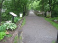
Abingdon Trailhead
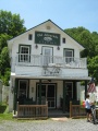
Alvarado Station
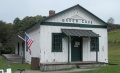
Green Cove Station