Loading map...
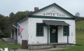
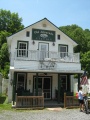
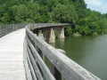
{"format":"googlemaps3","type":"TERRAIN","minzoom":false,"maxzoom":false,"types":["SATELLITE","HYBRID","TERRAIN"],"limit":50,"offset":0,"link":"none","sort":[""],"order":[],"headers":"show","mainlabel":"","intro":"","outro":"","searchlabel":"... further results","default":"","import-annotation":false,"width":"auto","height":"600px","centre":false,"title":"","label":"","icon":"","lines":[],"polygons":[],"circles":[],"rectangles":[],"copycoords":false,"static":false,"visitedicon":"","wmsoverlay":false,"zoom":false,"layers":[],"controls":["pan","zoom","type","scale","streetview","rotate"],"zoomstyle":"DEFAULT","typestyle":"DEFAULT","autoinfowindows":false,"resizable":false,"kmlrezoom":true,"poi":true,"cluster":false,"clustergridsize":60,"clustermaxzoom":20,"clusterzoomonclick":true,"clusteraveragecenter":true,"clusterminsize":2,"imageoverlays":[],"kml":[],"gkml":["https://tehcc.org/clubwiki/images/Virginia_Creeper_Trail.kml"],"searchmarkers":"","fullscreen":false,"scrollwheelzoom":false,"showtitle":false,"hidenamespace":true,"template":"Map Balloon Template","userparam":"","activeicon":"","pagelabel":false,"ajaxcoordproperty":"","ajaxquery":"","locations":[{"text":"\u003Cp\u003E\u003Cb\u003E\u003Ca class=\"mw-selflink selflink\"\u003EVirginia Creeper Trail\u003C/a\u003E\u003C/b\u003E\u003Cbr /\u003E\u003C/p\u003E\u003Chr /\u003E\u003Cp\u003E34.67\u0026#160;Mi (55.80\u0026#160;km)\u003Cbr /\u003EDifficulty: Medium\u003Cbr /\u003EMarking: None\u003C/p\u003E","title":"Virginia Creeper Trail","link":"","lat":36.6342700000000007776179700158536434173583984375,"lon":-81.7825700000000068712324718944728374481201171875,"icon":"/clubwiki/images/MarkerT.png"},{"text":"\u003Cp\u003E\u003Cb\u003EWhitetop Trailhead\u003C/b\u003E\u003Cbr /\u003E\u003C/p\u003E\u003Chr /\u003E\u003Cp\u003EWhitetop Trailhead\u003C/p\u003E","title":"Virginia Creeper Trail","link":"","lat":36.59961299999999795318217366002500057220458984375,"lon":-81.6249849999999952387952362187206745147705078125,"icon":"/clubwiki/images/MarkerT.png"},{"text":"\u003Cp\u003E\u003Cb\u003EDamascus\u003C/b\u003E\u003Cbr /\u003E\u003C/p\u003E\u003Chr /\u003E\u003Cp\u003EDamascus\u003C/p\u003E","title":"Virginia Creeper Trail","link":"","lat":36.634265999999996665792423300445079803466796875,"lon":-81.7825700000000068712324718944728374481201171875,"icon":"/clubwiki/images/MarkerG.png"},{"text":"\u003Cp\u003E\u003Cb\u003EAbingdon Trailhead\u003C/b\u003E\u003Cbr /\u003E\u003C/p\u003E\u003Chr /\u003E\u003Cp\u003E\u003Ca href=\"/wiki/File:Virginia_Creeper_Trail_-_Abingdon_Trailhead.jpg\" class=\"image\"\u003E\u003Cimg alt=\"Virginia Creeper Trail - Abingdon Trailhead.jpg\" src=\"/clubwiki/images/thumb/Virginia_Creeper_Trail_-_Abingdon_Trailhead.jpg/150px-Virginia_Creeper_Trail_-_Abingdon_Trailhead.jpg\" decoding=\"async\" width=\"150\" height=\"113\" srcset=\"/clubwiki/images/thumb/Virginia_Creeper_Trail_-_Abingdon_Trailhead.jpg/225px-Virginia_Creeper_Trail_-_Abingdon_Trailhead.jpg 1.5x, /clubwiki/images/thumb/Virginia_Creeper_Trail_-_Abingdon_Trailhead.jpg/300px-Virginia_Creeper_Trail_-_Abingdon_Trailhead.jpg 2x\" data-file-width=\"768\" data-file-height=\"576\" /\u003E\u003C/a\u003E\u003C/p\u003E","title":"Virginia Creeper Trail","link":"","lat":36.7092499999999972715158946812152862548828125,"lon":-81.9716329999999970823409967124462127685546875,"icon":"/clubwiki/images/MarkerT.png"},{"text":"\u003Cp\u003E\u003Cb\u003EWatauga Trailhead\u003C/b\u003E\u003Cbr /\u003E\u003C/p\u003E\u003Chr /\u003E\u003Cp\u003EWatauga Trailhead\u003C/p\u003E","title":"Virginia Creeper Trail","link":"","lat":36.6779999999999972715158946812152862548828125,"lon":-81.935100000000005593392415903508663177490234375,"icon":"/clubwiki/images/MarkerT.png"},{"text":"\u003Cp\u003E\u003Cb\u003EAlvarado Station\u003C/b\u003E\u003Cbr /\u003E\u003C/p\u003E\u003Chr /\u003E\u003Cp\u003E\u003Ca href=\"/wiki/File:Virginia_Creeper_Trail_-_Alvarado_Station.jpg\" class=\"image\"\u003E\u003Cimg alt=\"Virginia Creeper Trail - Alvarado Station.jpg\" src=\"/clubwiki/images/thumb/Virginia_Creeper_Trail_-_Alvarado_Station.jpg/150px-Virginia_Creeper_Trail_-_Alvarado_Station.jpg\" decoding=\"async\" width=\"150\" height=\"200\" srcset=\"/clubwiki/images/thumb/Virginia_Creeper_Trail_-_Alvarado_Station.jpg/225px-Virginia_Creeper_Trail_-_Alvarado_Station.jpg 1.5x, /clubwiki/images/thumb/Virginia_Creeper_Trail_-_Alvarado_Station.jpg/300px-Virginia_Creeper_Trail_-_Alvarado_Station.jpg 2x\" data-file-width=\"768\" data-file-height=\"1024\" /\u003E\u003C/a\u003E\u003C/p\u003E","title":"Virginia Creeper Trail","link":"","lat":36.65039999999999764668245916254818439483642578125,"lon":-81.8864999999999980673237587325274944305419921875,"icon":"/clubwiki/images/MarkerA.png"},{"text":"\u003Cp\u003E\u003Cb\u003ETrestle #12 over Holston River South and Middle Forks\u003C/b\u003E\u003Cbr /\u003E\u003C/p\u003E\u003Chr /\u003E\u003Cp\u003E\u003Ca href=\"/wiki/File:Virginia_Creeper_Trestle_12.jpg\" class=\"image\"\u003E\u003Cimg alt=\"Virginia Creeper Trestle 12.jpg\" src=\"/clubwiki/images/thumb/Virginia_Creeper_Trestle_12.jpg/150px-Virginia_Creeper_Trestle_12.jpg\" decoding=\"async\" width=\"150\" height=\"113\" srcset=\"/clubwiki/images/thumb/Virginia_Creeper_Trestle_12.jpg/225px-Virginia_Creeper_Trestle_12.jpg 1.5x, /clubwiki/images/thumb/Virginia_Creeper_Trestle_12.jpg/300px-Virginia_Creeper_Trestle_12.jpg 2x\" data-file-width=\"768\" data-file-height=\"576\" /\u003E\u003C/a\u003E\u003C/p\u003E","title":"Virginia Creeper Trail","link":"","lat":36.65458000000000282625478575937449932098388671875,"lon":-81.9033199999999936835592961870133876800537109375,"icon":"/clubwiki/images/MarkerL.png"},{"text":"\u003Cp\u003E\u003Cb\u003EGreen Cove Station\u003C/b\u003E\u003Cbr /\u003E\u003C/p\u003E\u003Chr /\u003E\u003Cp\u003E\u003Ca href=\"/wiki/File:VCT_-_Green_Cove_station.JPG\" class=\"image\"\u003E\u003Cimg alt=\"VCT - Green Cove station.JPG\" src=\"/clubwiki/images/thumb/VCT_-_Green_Cove_station.JPG/150px-VCT_-_Green_Cove_station.JPG\" decoding=\"async\" width=\"150\" height=\"92\" srcset=\"/clubwiki/images/thumb/VCT_-_Green_Cove_station.JPG/225px-VCT_-_Green_Cove_station.JPG 1.5x, /clubwiki/images/thumb/VCT_-_Green_Cove_station.JPG/300px-VCT_-_Green_Cove_station.JPG 2x\" data-file-width=\"1024\" data-file-height=\"625\" /\u003E\u003C/a\u003E\u003C/p\u003E","title":"Virginia Creeper Trail","link":"","lat":36.6192300000000017234924598596990108489990234375,"lon":-81.6445700000000016416379367001354694366455078125,"icon":"/clubwiki/images/MarkerA.png"}]}
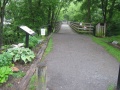
The Virginia Creeper Trail (VCT) is an excellent Rails-to-Trails conversion features forested path with 47 wooden trestles and bridges over creeks and rivers. Extremely popular bicycling ride.
The route is obvious due to its former railroad bed and well-worn path. There are two sets of mile markers - one for the former railroad, the other from Abingdon. The VCTC is also installing numbers on the trestles for more guidance and to aid emergency responders.
Out and back trips can be taken from any of the access points or shuttle can be arranged. Popular routes are taking a shuttle to Whitetop and riding 17 miles back down to Damascus or starting at Abingdon over to Damascus and back.
Wide gravel trail with wooden trestles from former railroad. Well maintained due to its high use.
The VCT is free to walk/ride. If you have your own bike and just need a shuttle (leaving between 8AM and 3PM), it's typically $14. Rental a bike for $15-18 (4 hours) or $20-21 (all day), and then the shuttle is around $10. Ride down from Whitetop to Damascus is considered half day, while all the way to Abingdon is full day.