Search results
Jump to navigation
Jump to search
Page title matches
- ...ed in [[Property:Page needs reviewed on]]. See [[Property:Trail page needs|Trail page needs]] for the current and previous designations. {{Trail page needs3 KB (465 words) - 22:06, 21 October 2015
- Here's the list of trail page needs. {{#ask: [[Category:Trail]]196 bytes (25 words) - 22:41, 2 January 2016
- -->{{Infobox Trail | Trail Use = {{Hike}}5 KB (598 words) - 12:12, 7 January 2023
- ...Please scroll down to edit the main content of the article. -->{{Infobox Trail | Trail Number = USFS Trail #6035 KB (730 words) - 18:24, 16 April 2023
- {{Trail |Trail Marking=Pink2 KB (315 words) - 21:57, 19 September 2021
- {{Trail |Trail Highlight=A hike up the west side of Holston Mountain past an overlook4 KB (621 words) - 10:17, 4 January 2023
- This is the "Trail Stub" template. Its use is for the [[Form:Park|Park Form]] to list trails t {{Trail Stub778 bytes (102 words) - 15:34, 24 November 2019
- Not too surprising there are multiple uses of Summit Trail. The following are known. *[[Summit Trail (Elk Knob)|Summit Trail in Elk Knob State Park]] North Carolina256 bytes (40 words) - 22:39, 2 December 2019
- ...is a property of type [[Has type::Text|Text]]. It is used to describe the trail blaze, unless otherwise unique, simply the color name should suffice.154 bytes (27 words) - 13:43, 15 November 2018
- '''Trail Lows and Highs''' are as simple as it sounds. If using a GPS points or trac '''Trail elevations and elevation changes''' is trickier than one would initially be2 KB (313 words) - 08:19, 7 December 2019
- 46 bytes (9 words) - 11:22, 18 November 2018
- ...holds comments from a trail trip report focusing on the conditions of the trail. Not to be confused with [[Property:Hike Comment]] which holds general comm227 bytes (39 words) - 14:17, 18 November 2018
- {{Trail |Trail Highlight=Although your likely goal, not the typical access6 KB (865 words) - 10:56, 7 January 2023
File:Trail Markers.JPG |File name=Trail Markers.JPG |Trail=Phipps Bend Trail(3,024 × 4,032 (5.68 MB)) - 08:55, 9 August 2020
File:Trail intersection.jpg |File name=Trail intersection.jpg |Trail=Ridge Crest Trail(640 × 480 (165 KB)) - 17:24, 6 September 2020- {{Trail |Trail Highlight=Good for beginners2 KB (343 words) - 19:04, 11 September 2020
- {{Trail |Trail Highlight=Wander around more than seven sinkholes1 KB (205 words) - 21:28, 11 September 2020
- {{Trail |Trail Highlight=One mile extension to Raider's Run1 KB (162 words) - 10:09, 21 September 2020
- {{Trail |Trail Highlight=A steep climb to a 180° stunning view of the countryside1 KB (181 words) - 10:34, 21 September 2020
- {{Trail |Trail Highlight=Additional hike option to Molly's Knob and Vista Trail2 KB (235 words) - 09:17, 22 September 2020


Page text matches
- ...l'. It is normally used in infoboxes to display allowed use on or near the trail or at the park.493 bytes (72 words) - 11:41, 20 November 2018
- [[ClubWiki:Creating a Trail]] [[ClubWiki:Creating a Trail KML]]6 KB (877 words) - 18:29, 3 July 2020
- |Banner Image=File:White Rock Trail overlook.JPG |Trail Map Link=https://www.johnsoncitytn.org/document_center/Residents/Buffalo%205 KB (873 words) - 12:12, 7 January 2023
- {{Trail |Trail Highlight=An easy short trail to a remote and beautiful waterfall3 KB (486 words) - 14:14, 17 July 2023
- ...The river trail ends at the Clinch River, so I backtracked to Copper Ridge Trail and up a 350’ elevation climb to the overlook. (I would recommend the ove3 KB (462 words) - 07:50, 2 April 2014
- {{Trail |Trail Marking=Red9 KB (1,323 words) - 15:45, 24 June 2023
- |Trail Condition=Clear335 bytes (55 words) - 07:05, 7 July 2023
- |Trails=Ewing Trail |Trail Condition=Clear1 KB (224 words) - 18:13, 14 July 2023
- [[ClubWiki:Creating_a_Trail]] has information on how to add (or modify) a trail specific to this site When creating or modifying trail or park pages, applying wiki categories are not used. The templates will ap7 KB (1,001 words) - 13:36, 1 January 2020
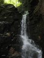
File:Rock Creek Falls.jpg |Trail=Rock Creek Falls(900 × 1,200 (420 KB)) - 11:06, 19 September 2021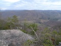
File:High Butte.jpg |Trail=Roaring Branch Trail(600 × 450 (71 KB)) - 22:19, 27 July 2020- {{Trail |Trail Highlight=Starting waterfall, view of the Powell River Valley5 KB (783 words) - 22:37, 27 July 2020

File:Roaring branch trail profile.png |File name=roaring branch trail profile.png |Trail=Roaring Branch Trail(1,160 × 660 (22 KB)) - 22:30, 27 July 2020- |Trail Condition=Clear |Trail Comment=The trail was in excellent condition.510 bytes (81 words) - 15:07, 28 July 2020
- |Trail Condition=Clear |Trail Comment=Little soggy, otherwise portions seen were clear. Bridge from wetla454 bytes (69 words) - 09:02, 1 August 2020
- Welcome to our online repository for everything trail related within a reasonable distance from our club's center in Kingsport TN ...a trailhead GPS coordinate. Click on the balloon title to take you to that trail.9 KB (1,664 words) - 09:07, 13 December 2019
- Below are the images seen on the trail infoboxes, what they mean, and how to use them if you edit trails. !Name in trail editing lists2 KB (295 words) - 15:22, 6 October 2019
- |Trail Condition=Clear |Trail Comment=A little dry362 bytes (55 words) - 08:46, 12 October 2019
- ...ngs with roughly a dozen folks of all ages hiking this “medium” difficulty trail. On this Sunday trek were Aaron Kelly and Vic Hasler. ...ly one slight slip and dip. The Cherokee National Forest has worked on the trail including putting in stepping stones at each crossing, but most were under3 KB (585 words) - 06:48, 3 April 2014
- {{Trail |Trail Highlight=Rock-lined gorge with sandstone cliffs and cascading creek to vie6 KB (962 words) - 11:06, 25 April 2024


