Loading map...
{"format":"googlemaps3","type":"TERRAIN","minzoom":false,"maxzoom":false,"types":["SATELLITE","HYBRID","TERRAIN"],"limit":50,"offset":0,"link":"none","sort":[""],"order":[],"headers":"show","mainlabel":"","intro":"","outro":"","searchlabel":"... further results","default":"","import-annotation":false,"width":"auto","height":"600px","centre":false,"title":"","label":"","icon":"","lines":[],"polygons":[],"circles":[],"rectangles":[],"copycoords":false,"static":false,"visitedicon":"","wmsoverlay":false,"zoom":false,"layers":[],"controls":["pan","zoom","type","scale","streetview","rotate"],"zoomstyle":"DEFAULT","typestyle":"DEFAULT","autoinfowindows":false,"resizable":false,"kmlrezoom":true,"poi":true,"cluster":false,"clustergridsize":60,"clustermaxzoom":20,"clusterzoomonclick":true,"clusteraveragecenter":true,"clusterminsize":2,"imageoverlays":[],"kml":[],"gkml":["https://tehcc.org/clubwiki/images/Big_Oak_Trail.kml","https://tehcc.org/clubwiki/images/Chinquapin_Trail.kml","https://tehcc.org/clubwiki/images/Fire_Tower_Trail.kml","https://tehcc.org/clubwiki/images/Lake_Road_(Bays_Mountain_Park).kml"],"searchmarkers":"","fullscreen":false,"scrollwheelzoom":false,"showtitle":false,"hidenamespace":true,"template":"Map Balloon Template","userparam":"","activeicon":"","pagelabel":false,"ajaxcoordproperty":"","ajaxquery":"","locations":[{"text":"\u003Cp\u003E\u003Cb\u003E\u003Ca href=\"/wiki/Big_Oak_Trail\" title=\"Big Oak Trail\"\u003EBig Oak Trail\u003C/a\u003E\u003C/b\u003E\u003Cbr /\u003E\u003C/p\u003E\u003Chr /\u003E\u003Cp\u003E0.93\u0026#160;Mi (1.49\u0026#160;km)\u003Cbr /\u003EDifficulty: Easy\u003Cbr /\u003EMarking: Signs\u003C/p\u003E","title":"Big Oak Trail","link":"","lat":36.51359000000000065710992203094065189361572265625,"lon":-82.60611000000000103682396002113819122314453125,"icon":"/clubwiki/images/MarkerT.png"},{"text":"\u003Cp\u003E\u003Cb\u003ETrailhead at \u003Ca href=\"/wiki/Lake_Road_(Bays_Mountain_Park)\" title=\"Lake Road (Bays Mountain Park)\"\u003ELake Road\u003C/a\u003E\u003C/b\u003E\u003Cbr /\u003E\u003C/p\u003E\u003Chr /\u003E\u003Cp\u003E\u003Ca href=\"/wiki/File:BMP_Lake_Road_sign_at_Big_Oak_Trail.JPG\" class=\"image\"\u003E\u003Cimg alt=\"BMP Lake Road sign at Big Oak Trail.JPG\" src=\"/clubwiki/images/thumb/BMP_Lake_Road_sign_at_Big_Oak_Trail.JPG/50px-BMP_Lake_Road_sign_at_Big_Oak_Trail.JPG\" decoding=\"async\" width=\"50\" height=\"76\" srcset=\"/clubwiki/images/thumb/BMP_Lake_Road_sign_at_Big_Oak_Trail.JPG/75px-BMP_Lake_Road_sign_at_Big_Oak_Trail.JPG 1.5x, /clubwiki/images/thumb/BMP_Lake_Road_sign_at_Big_Oak_Trail.JPG/100px-BMP_Lake_Road_sign_at_Big_Oak_Trail.JPG 2x\" data-file-width=\"296\" data-file-height=\"448\" /\u003E\u003C/a\u003E\u003C/p\u003E","title":"Big Oak Trail","link":"","lat":36.51368000000000080262907431460916996002197265625,"lon":-82.606030000000004065441316924989223480224609375,"icon":"/clubwiki/images/MarkerT.png"},{"text":"\u003Cp\u003E\u003Cb\u003EJunction with \u003Ca class=\"mw-selflink selflink\"\u003EChinquapin Trail\u003C/a\u003E\u003C/b\u003E\u003Cbr /\u003E\u003C/p\u003E\u003Chr /\u003E\u003Cp\u003E\u003Ca href=\"/wiki/File:BMP_Big_Oak_-_Chinquapin_Trail_sign.JPG\" class=\"image\"\u003E\u003Cimg alt=\"BMP Big Oak - Chinquapin Trail sign.JPG\" src=\"/clubwiki/images/thumb/BMP_Big_Oak_-_Chinquapin_Trail_sign.JPG/50px-BMP_Big_Oak_-_Chinquapin_Trail_sign.JPG\" decoding=\"async\" width=\"50\" height=\"175\" srcset=\"/clubwiki/images/thumb/BMP_Big_Oak_-_Chinquapin_Trail_sign.JPG/75px-BMP_Big_Oak_-_Chinquapin_Trail_sign.JPG 1.5x, /clubwiki/images/thumb/BMP_Big_Oak_-_Chinquapin_Trail_sign.JPG/100px-BMP_Big_Oak_-_Chinquapin_Trail_sign.JPG 2x\" data-file-width=\"128\" data-file-height=\"448\" /\u003E\u003C/a\u003E\u003C/p\u003E","title":"Big Oak Trail","link":"","lat":36.51451999999999742385625722818076610565185546875,"lon":-82.606009999999997717168298549950122833251953125,"icon":"/clubwiki/images/MarkerT.png"},{"text":"\u003Cp\u003E\u003Cb\u003EAntennas, elevation 2250'\u003C/b\u003E\u003Cbr /\u003E\u003C/p\u003E\u003Chr /\u003E\u003Cp\u003E\u003Ca href=\"/wiki/File:BMP_Antennas.JPG\" class=\"image\"\u003E\u003Cimg alt=\"BMP Antennas.JPG\" src=\"/clubwiki/images/thumb/BMP_Antennas.JPG/150px-BMP_Antennas.JPG\" decoding=\"async\" width=\"150\" height=\"261\" srcset=\"/clubwiki/images/thumb/BMP_Antennas.JPG/225px-BMP_Antennas.JPG 1.5x, /clubwiki/images/BMP_Antennas.JPG 2x\" data-file-width=\"257\" data-file-height=\"448\" /\u003E\u003C/a\u003E\u003C/p\u003E","title":"Big Oak Trail","link":"","lat":36.5272599999999982856024871580302715301513671875,"lon":-82.5861000000000018417267710901796817779541015625,"icon":"/clubwiki/images/MarkerE.png"},{"text":"\u003Cp\u003E\u003Cb\u003ETrailhead at \u003Ca href=\"/wiki/Azalea\" title=\"Azalea\"\u003EAzalea\u003C/a\u003E\u003C/b\u003E\u003Cbr /\u003E\u003C/p\u003E\u003Chr /\u003E\u003Cp\u003E\u003Ca href=\"/wiki/File:BMP_Split_at_Azalea_and_Big_Oak_Trails.JPG\" class=\"image\"\u003E\u003Cimg alt=\"BMP Split at Azalea and Big Oak Trails.JPG\" src=\"/clubwiki/images/thumb/BMP_Split_at_Azalea_and_Big_Oak_Trails.JPG/150px-BMP_Split_at_Azalea_and_Big_Oak_Trails.JPG\" decoding=\"async\" width=\"150\" height=\"113\" srcset=\"/clubwiki/images/thumb/BMP_Split_at_Azalea_and_Big_Oak_Trails.JPG/225px-BMP_Split_at_Azalea_and_Big_Oak_Trails.JPG 1.5x, /clubwiki/images/thumb/BMP_Split_at_Azalea_and_Big_Oak_Trails.JPG/300px-BMP_Split_at_Azalea_and_Big_Oak_Trails.JPG 2x\" data-file-width=\"448\" data-file-height=\"336\" /\u003E\u003C/a\u003E\u003C/p\u003E","title":"Big Oak Trail","link":"","lat":36.522210000000001173248165287077426910400390625,"lon":-82.5928300000000064073901739902794361114501953125,"icon":"/clubwiki/images/MarkerT.png"},{"text":"\u003Cp\u003E\u003Cb\u003E\u003Ca class=\"mw-selflink selflink\"\u003EChinquapin Trail\u003C/a\u003E\u003C/b\u003E\u003Cbr /\u003E\u003C/p\u003E\u003Chr /\u003E\u003Cp\u003E1.56\u0026#160;Mi (2.50\u0026#160;km)\u003Cbr /\u003EDifficulty: Medium\u003Cbr /\u003EMarking: Signs\u003C/p\u003E","title":"Chinquapin Trail","link":"","lat":36.514499999999998181010596454143524169921875,"lon":-82.6060700000000025511326384730637073516845703125,"icon":"/clubwiki/images/MarkerT.png"},{"text":"\u003Cp\u003E\u003Cb\u003ETrailhead at \u003Ca href=\"/clubwiki/index.php?title=Big_Oak\u0026amp;action=edit\u0026amp;redlink=1\" class=\"new\" title=\"Big Oak (page does not exist)\"\u003EBig Oak\u003C/a\u003E\u003C/b\u003E\u003Cbr /\u003E\u003C/p\u003E\u003Chr /\u003E\u003Cp\u003E\u003Ca href=\"/wiki/File:BMP_Big_Oak_-_Chinquapin_Trail_sign.JPG\" class=\"image\"\u003E\u003Cimg alt=\"BMP Big Oak - Chinquapin Trail sign.JPG\" src=\"/clubwiki/images/thumb/BMP_Big_Oak_-_Chinquapin_Trail_sign.JPG/50px-BMP_Big_Oak_-_Chinquapin_Trail_sign.JPG\" decoding=\"async\" width=\"50\" height=\"175\" srcset=\"/clubwiki/images/thumb/BMP_Big_Oak_-_Chinquapin_Trail_sign.JPG/75px-BMP_Big_Oak_-_Chinquapin_Trail_sign.JPG 1.5x, /clubwiki/images/thumb/BMP_Big_Oak_-_Chinquapin_Trail_sign.JPG/100px-BMP_Big_Oak_-_Chinquapin_Trail_sign.JPG 2x\" data-file-width=\"128\" data-file-height=\"448\" /\u003E\u003C/a\u003E\u003C/p\u003E","title":"Chinquapin Trail","link":"","lat":36.51451999999999742385625722818076610565185546875,"lon":-82.606009999999997717168298549950122833251953125,"icon":"/clubwiki/images/MarkerT.png"},{"text":"\u003Cp\u003E\u003Cb\u003ETrail bridge by Troop 51\u003C/b\u003E\u003Cbr /\u003E\u003C/p\u003E\u003Chr /\u003E\u003Cp\u003E\u003Ca href=\"/wiki/File:BMP_Chinquapin_Trail_bridge1.JPG\" class=\"image\"\u003E\u003Cimg alt=\"BMP Chinquapin Trail bridge1.JPG\" src=\"/clubwiki/images/thumb/BMP_Chinquapin_Trail_bridge1.JPG/150px-BMP_Chinquapin_Trail_bridge1.JPG\" decoding=\"async\" width=\"150\" height=\"101\" srcset=\"/clubwiki/images/thumb/BMP_Chinquapin_Trail_bridge1.JPG/225px-BMP_Chinquapin_Trail_bridge1.JPG 1.5x, /clubwiki/images/thumb/BMP_Chinquapin_Trail_bridge1.JPG/300px-BMP_Chinquapin_Trail_bridge1.JPG 2x\" data-file-width=\"448\" data-file-height=\"301\" /\u003E\u003C/a\u003E\u003C/p\u003E","title":"Chinquapin Trail","link":"","lat":36.5152700000000010049916454590857028961181640625,"lon":-82.6072199999999980946085997857153415679931640625,"icon":"/clubwiki/images/MarkerL.png"},{"text":"\u003Cp\u003E\u003Cb\u003EJunction with \u003Ca href=\"/wiki/Fire_Tower_Trail\" title=\"Fire Tower Trail\"\u003EFire Tower Trail\u003C/a\u003E\u003C/b\u003E\u003Cbr /\u003E\u003C/p\u003E\u003Chr /\u003E\u003Cp\u003E\u003Ca href=\"/wiki/File:BMP_FT-CQ_sign.JPG\" class=\"image\"\u003E\u003Cimg alt=\"BMP FT-CQ sign.JPG\" src=\"/clubwiki/images/thumb/BMP_FT-CQ_sign.JPG/50px-BMP_FT-CQ_sign.JPG\" decoding=\"async\" width=\"50\" height=\"220\" srcset=\"/clubwiki/images/thumb/BMP_FT-CQ_sign.JPG/75px-BMP_FT-CQ_sign.JPG 1.5x, /clubwiki/images/thumb/BMP_FT-CQ_sign.JPG/100px-BMP_FT-CQ_sign.JPG 2x\" data-file-width=\"102\" data-file-height=\"448\" /\u003E\u003C/a\u003E\u003C/p\u003E","title":"Chinquapin Trail","link":"","lat":36.5127600000000001045918907038867473602294921875,"lon":-82.61763999999999441570253111422061920166015625,"icon":"/clubwiki/images/MarkerT.png"},{"text":"\u003Cp\u003E\u003Cb\u003ETrail bridge by Troop 51\u003C/b\u003E\u003Cbr /\u003E\u003C/p\u003E\u003Chr /\u003E\u003Cp\u003E\u003Ca href=\"/wiki/File:BMP_Chinquapin_Trail_bridge2.JPG\" class=\"image\"\u003E\u003Cimg alt=\"BMP Chinquapin Trail bridge2.JPG\" src=\"/clubwiki/images/thumb/BMP_Chinquapin_Trail_bridge2.JPG/150px-BMP_Chinquapin_Trail_bridge2.JPG\" decoding=\"async\" width=\"150\" height=\"192\" srcset=\"/clubwiki/images/thumb/BMP_Chinquapin_Trail_bridge2.JPG/225px-BMP_Chinquapin_Trail_bridge2.JPG 1.5x, /clubwiki/images/thumb/BMP_Chinquapin_Trail_bridge2.JPG/300px-BMP_Chinquapin_Trail_bridge2.JPG 2x\" data-file-width=\"336\" data-file-height=\"430\" /\u003E\u003C/a\u003E\u003C/p\u003E","title":"Chinquapin Trail","link":"","lat":36.5126800000000031332092476077377796173095703125,"lon":-82.6187900000000041700332076288759708404541015625,"icon":"/clubwiki/images/MarkerL.png"},{"text":"\u003Cp\u003E\u003Cb\u003E{{{1}}}\u003C/b\u003E\u003Cbr /\u003E\u003C/p\u003E\u003Chr /\u003E\u003Cp\u003E{{{2}}}\u003C/p\u003E","title":"Chinquapin Trail","link":"","lat":36.51066999999999751480572740547358989715576171875,"lon":-82.6208299999999979945641825906932353973388671875,"icon":"/clubwiki/images/MarkerL.png"},{"text":"\u003Cp\u003E\u003Cb\u003ETrailhead at \u003Ca href=\"/wiki/Lake_Road_(Bays_Mountain_Park)\" title=\"Lake Road (Bays Mountain Park)\"\u003ELake Road\u003C/a\u003E\u003C/b\u003E\u003Cbr /\u003E\u003C/p\u003E\u003Chr /\u003E\u003Cp\u003ETrailhead at \u003Ca href=\"/wiki/Lake_Road_(Bays_Mountain_Park)\" title=\"Lake Road (Bays Mountain Park)\"\u003ELake Road\u003C/a\u003E\u003C/p\u003E","title":"Chinquapin Trail","link":"","lat":36.50950999999999879719325690530240535736083984375,"lon":-82.6213699999999988676790962927043437957763671875,"icon":"/clubwiki/images/MarkerT.png"},{"text":"\u003Cp\u003E\u003Cb\u003E\u003Ca href=\"/wiki/Fire_Tower_Trail\" title=\"Fire Tower Trail\"\u003EFire Tower Trail\u003C/a\u003E\u003C/b\u003E\u003Cbr /\u003E\u003C/p\u003E\u003Chr /\u003E\u003Cp\u003E0.70\u0026#160;Mi (1.13\u0026#160;km)\u003Cbr /\u003EDifficulty: Medium\u003Cbr /\u003EMarking: Signs\u003C/p\u003E","title":"Fire Tower Trail","link":"","lat":36.51201999999999969759301166050136089324951171875,"lon":-82.61669000000000551153789274394512176513671875,"icon":"/clubwiki/images/MarkerT.png"},{"text":"\u003Cp\u003E\u003Cb\u003EGarden Mountain/Kingsport Lookout Tower\u003C/b\u003E\u003Cbr /\u003E\u003C/p\u003E\u003Chr /\u003E\u003Cp\u003E\u003Ca href=\"/wiki/File:BMP_Firetower_Trail_tower.jpg\" class=\"image\" title=\"Fire tower\"\u003E\u003Cimg alt=\"Fire tower\" src=\"/clubwiki/images/thumb/BMP_Firetower_Trail_tower.jpg/150px-BMP_Firetower_Trail_tower.jpg\" decoding=\"async\" width=\"150\" height=\"201\" srcset=\"/clubwiki/images/thumb/BMP_Firetower_Trail_tower.jpg/225px-BMP_Firetower_Trail_tower.jpg 1.5x, /clubwiki/images/BMP_Firetower_Trail_tower.jpg 2x\" data-file-width=\"300\" data-file-height=\"401\" /\u003E\u003C/a\u003E\u003C/p\u003E","title":"Fire Tower Trail","link":"","lat":36.5154500000000012960299500264227390289306640625,"lon":-82.6238000000000027966962079517543315887451171875,"icon":"/clubwiki/images/MarkerE.png"},{"text":"\u003Cp\u003E\u003Cb\u003EJunction with \u003Ca href=\"/wiki/Lake_Road_(Bays_Mountain_Park)\" title=\"Lake Road (Bays Mountain Park)\"\u003ELake Road\u003C/a\u003E\u003C/b\u003E\u003Cbr /\u003E\u003C/p\u003E\u003Chr /\u003E\u003Cp\u003EJunction with \u003Ca href=\"/wiki/Lake_Road_(Bays_Mountain_Park)\" title=\"Lake Road (Bays Mountain Park)\"\u003ELake Road\u003C/a\u003E\u003C/p\u003E","title":"Fire Tower Trail","link":"","lat":36.51201999999999969759301166050136089324951171875,"lon":-82.61669000000000551153789274394512176513671875,"icon":"/clubwiki/images/MarkerG.png"},{"text":"\u003Cp\u003E\u003Cb\u003E\u003Ca href=\"/wiki/Lake_Road_(Bays_Mountain_Park)\" title=\"Lake Road (Bays Mountain Park)\"\u003ELake Road (Bays Mountain Park)\u003C/a\u003E\u003C/b\u003E\u003Cbr /\u003E\u003C/p\u003E\u003Chr /\u003E\u003Cp\u003E4.33\u0026#160;Mi (6.96\u0026#160;km)\u003Cbr /\u003EDifficulty: Easy\u003Cbr /\u003EMarking: Signs\u003C/p\u003E","title":"Lake Road (Bays Mountain Park)","link":"","lat":36.50645999999999702367858844809234142303466796875,"lon":-82.63128000000000383806764148175716400146484375,"icon":"/clubwiki/images/MarkerT.png"},{"text":"\u003Cp\u003E\u003Cb\u003ELedbetter Gap\u003C/b\u003E\u003Cbr /\u003E\u003C/p\u003E\u003Chr /\u003E\u003Cp\u003E\u003Ca href=\"/wiki/File:BMP_Ledbetter_Gap_sign.JPG\" class=\"image\"\u003E\u003Cimg alt=\"BMP Ledbetter Gap sign.JPG\" src=\"/clubwiki/images/thumb/BMP_Ledbetter_Gap_sign.JPG/150px-BMP_Ledbetter_Gap_sign.JPG\" decoding=\"async\" width=\"150\" height=\"148\" srcset=\"/clubwiki/images/thumb/BMP_Ledbetter_Gap_sign.JPG/225px-BMP_Ledbetter_Gap_sign.JPG 1.5x, /clubwiki/images/thumb/BMP_Ledbetter_Gap_sign.JPG/300px-BMP_Ledbetter_Gap_sign.JPG 2x\" data-file-width=\"340\" data-file-height=\"336\" /\u003E\u003C/a\u003E\u003Cbr /\u003ECrossroads with \u003Ca href=\"/wiki/Bays_Ridge_Road\" title=\"Bays Ridge Road\"\u003EBays Ridge Road\u003C/a\u003E and \u003Ca href=\"/wiki/Front_Hollow_Road\" title=\"Front Hollow Road\"\u003EFront Hollow Road\u003C/a\u003E\u003C/p\u003E","title":"Lake Road (Bays Mountain Park)","link":"","lat":36.4979000000000013415046851150691509246826171875,"lon":-82.627712999999999965439201332628726959228515625,"icon":"/clubwiki/images/MarkerT.png"},{"text":"\u003Cp\u003E\u003Cb\u003E\u003Ca href=\"/wiki/Orchid_Trail\" title=\"Orchid Trail\"\u003EOrchid Trail\u003C/a\u003E\u003C/b\u003E\u003Cbr /\u003E\u003C/p\u003E\u003Chr /\u003E\u003Cp\u003E\u003Ca href=\"/wiki/File:BMP_Orchid_Trail_sign.JPG\" class=\"image\"\u003E\u003Cimg alt=\"BMP Orchid Trail sign.JPG\" src=\"/clubwiki/images/thumb/BMP_Orchid_Trail_sign.JPG/50px-BMP_Orchid_Trail_sign.JPG\" decoding=\"async\" width=\"50\" height=\"89\" srcset=\"/clubwiki/images/thumb/BMP_Orchid_Trail_sign.JPG/75px-BMP_Orchid_Trail_sign.JPG 1.5x, /clubwiki/images/thumb/BMP_Orchid_Trail_sign.JPG/100px-BMP_Orchid_Trail_sign.JPG 2x\" data-file-width=\"252\" data-file-height=\"448\" /\u003E\u003C/a\u003E\u003C/p\u003E","title":"Lake Road (Bays Mountain Park)","link":"","lat":36.50348999999999932697392068803310394287109375,"lon":-82.618930000000005975380190648138523101806640625,"icon":"/clubwiki/images/MarkerT.png"},{"text":"\u003Cp\u003E\u003Cb\u003ECrossroads\u003C/b\u003E\u003Cbr /\u003E\u003C/p\u003E\u003Chr /\u003E\u003Cp\u003E\u003Ca href=\"/wiki/Back_Hollow_Road\" title=\"Back Hollow Road\"\u003EBack Hollow Road\u003C/a\u003E and \u003Ca href=\"/wiki/River_Mountain_Road\" title=\"River Mountain Road\"\u003ERiver Mountain Road\u003C/a\u003E\u003C/p\u003E","title":"Lake Road (Bays Mountain Park)","link":"","lat":36.50654800000000221871232497505843639373779296875,"lon":-82.6312779999999946767275105230510234832763671875,"icon":"/clubwiki/images/MarkerT.png"},{"text":"\u003Cp\u003E\u003Cb\u003EOld quarry used for stone to create reservoir dam\u003C/b\u003E\u003Cbr /\u003E\u003C/p\u003E\u003Chr /\u003E\u003Cp\u003EOld quarry used for stone to create reservoir dam\u003C/p\u003E","title":"Lake Road (Bays Mountain Park)","link":"","lat":36.50513000000000118916432256810367107391357421875,"lon":-82.6295300000000025875124265439808368682861328125,"icon":"/clubwiki/images/MarkerD.png"},{"text":"\u003Cp\u003E\u003Cb\u003E\u003Ca href=\"/wiki/Cherry_Knobs\" title=\"Cherry Knobs\"\u003ECherry Knobs\u003C/a\u003E\u003C/b\u003E\u003Cbr /\u003E\u003C/p\u003E\u003Chr /\u003E\u003Cp\u003E\u003Ca href=\"/wiki/Cherry_Knobs\" title=\"Cherry Knobs\"\u003ECherry Knobs\u003C/a\u003E\u003C/p\u003E","title":"Lake Road (Bays Mountain Park)","link":"","lat":36.50344799999999878536982578225433826446533203125,"lon":-82.6285299999999978126652422361075878143310546875,"icon":"/clubwiki/images/MarkerT.png"},{"text":"\u003Cp\u003E\u003Cb\u003E\u003Ca href=\"/wiki/Pine_Trail\" title=\"Pine Trail\"\u003EPine Trail\u003C/a\u003E\u003C/b\u003E\u003Cbr /\u003E\u003C/p\u003E\u003Chr /\u003E\u003Cp\u003E\u003Ca href=\"/wiki/Pine_Trail\" title=\"Pine Trail\"\u003EPine Trail\u003C/a\u003E\u003C/p\u003E","title":"Lake Road (Bays Mountain Park)","link":"","lat":36.50708800000000309182723867706954479217529296875,"lon":-82.61354000000000041836756281554698944091796875,"icon":"/clubwiki/images/MarkerT.png"},{"text":"\u003Cp\u003E\u003Cb\u003EJunction with \u003Ca class=\"mw-selflink selflink\"\u003EChinquapin Trail\u003C/a\u003E\u003C/b\u003E\u003Cbr /\u003E\u003C/p\u003E\u003Chr /\u003E\u003Cp\u003EJunction with \u003Ca class=\"mw-selflink selflink\"\u003EChinquapin Trail\u003C/a\u003E\u003C/p\u003E","title":"Lake Road (Bays Mountain Park)","link":"","lat":36.50945999999999713736542616970837116241455078125,"lon":-82.62130999999999403371475636959075927734375,"icon":"/clubwiki/images/MarkerT.png"},{"text":"\u003Cp\u003E\u003Cb\u003E\u003Ca href=\"/wiki/Cherry_Knobs\" title=\"Cherry Knobs\"\u003ECherry Knobs\u003C/a\u003E\u003C/b\u003E\u003Cbr /\u003E\u003C/p\u003E\u003Chr /\u003E\u003Cp\u003E\u003Ca href=\"/wiki/Cherry_Knobs\" title=\"Cherry Knobs\"\u003ECherry Knobs\u003C/a\u003E\u003C/p\u003E","title":"Lake Road (Bays Mountain Park)","link":"","lat":36.50097199999999730835043010301887989044189453125,"lon":-82.6309739999999948167896945960819721221923828125,"icon":"/clubwiki/images/MarkerT.png"},{"text":"\u003Cp\u003E\u003Cb\u003E\u003Ca href=\"/wiki/Bays_Ridge_Road\" title=\"Bays Ridge Road\"\u003EBays Ridge Road\u003C/a\u003E\u003C/b\u003E\u003Cbr /\u003E\u003C/p\u003E\u003Chr /\u003E\u003Cp\u003E\u003Ca href=\"/wiki/File:BMP_LakeRd-BaysRidgeRd_sign.JPG\" class=\"image\"\u003E\u003Cimg alt=\"BMP LakeRd-BaysRidgeRd sign.JPG\" src=\"/clubwiki/images/thumb/BMP_LakeRd-BaysRidgeRd_sign.JPG/50px-BMP_LakeRd-BaysRidgeRd_sign.JPG\" decoding=\"async\" width=\"50\" height=\"179\" srcset=\"/clubwiki/images/thumb/BMP_LakeRd-BaysRidgeRd_sign.JPG/75px-BMP_LakeRd-BaysRidgeRd_sign.JPG 1.5x, /clubwiki/images/thumb/BMP_LakeRd-BaysRidgeRd_sign.JPG/100px-BMP_LakeRd-BaysRidgeRd_sign.JPG 2x\" data-file-width=\"125\" data-file-height=\"448\" /\u003E\u003C/a\u003E\u003C/p\u003E","title":"Lake Road (Bays Mountain Park)","link":"","lat":36.50761299999999920373738859780132770538330078125,"lon":-82.6126579999999961501089273951947689056396484375,"icon":"/clubwiki/images/MarkerT.png"}]}
From the main parking lot, take Lake Road around to unmarked trailhead or jump on Big Oak for short distance for other trailhead.
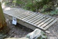
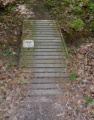
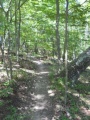
The path meanders through the forest with planned switchbacks and bridge crossing.
Hard packed trail with groove down the middle from the mountain bikes. Some rocks located at key spots. Several wood bridges constructed by BSA Troop 51.


