Unused files
Jump to navigation
Jump to search
The following files exist but are not embedded in any page. Please note that other websites may link to a file with a direct URL, and so may still be listed here despite being in active use.
Showing below up to 50 results in range #1 to #50.
-
 Baby-pede.jpg 375 × 480; 48 KB
-
 TEHCClogo2.jpg 1,210 × 1,200; 211 KB
-
 Lakeside Trailhead from Dam.jpg 600 × 450; 104 KB
-
 Lakeside trail - evergreen grove.jpg 500 × 375; 83 KB
-
 Lakeside Trail - former aviary area.jpg 600 × 450; 69 KB
-
 Kiner Hollow Trailhead in Laurel Run Park.jpg 768 × 576; 164 KB
-
 Laurel Run Trail creek.jpg 768 × 576; 175 KB
-
 GentryCreekFalls.jpg 187 × 273; 16 KB
-
 GentryCreek20070811-01.jpg 314 × 235; 21 KB
-
 GentryCreek20070811-03.jpg 251 × 188; 32 KB
-
 The Great Channels1.jpg 768 × 1,024; 139 KB
-
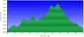
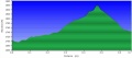
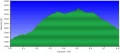
 Roaring Branch Trail profile.JPG 754 × 331; 32 KB
-
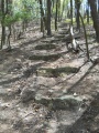
 Roaring Branch Trail - stone steps.JPG 1,154 × 2,086; 507 KB
-
 Roaring Branch Trail - wide creek crossing.JPG 2,572 × 1,928; 1.01 MB
-
 WPSP Fall Creek Loop Trail profile.JPG 711 × 313; 31 KB
-
 View from ChimneyTop.jpg 600 × 450; 169 KB
-
 WPSP Overlook Trail path.jpg 351 × 265; 23 KB
-
 WPSP Overlook Trail - Viewing I-81 Bridge.jpg 265 × 351; 18 KB
-
 WPSP Lake Hollow Trail - View towards Duck Island.JPG 1,024 × 526; 83 KB
-
 WPSP Boat Launch.JPG 1,024 × 741; 299 KB
-
 WPSP Lakeshore Trail sign2.JPG 448 × 336; 61 KB
-
 WPSP Lakeshore Trail bridge.JPG 448 × 336; 64 KB
-
 WPSP Lakeshore Trail - View of Fall Creek Road bridge.JPG 448 × 283; 35 KB
-
 WPSP Lakeshore Trail - View of Lone Cedar Overlook.JPG 448 × 336; 42 KB
-
 WPSP Connector Trail - wooden bridges.JPG 336 × 448; 57 KB
-
 WPSP Connector Trail - Girls Inc bench.JPG 448 × 336; 71 KB
-
 WPSP Connector Trail fishing spot view.JPG 448 × 336; 39 KB
-
 WPSP Lake Hollow Trail sign2.JPG 448 × 255; 53 KB
-
 WPSP Lake Hollow Trail - View towards main boat ramp.JPG 448 × 275; 30 KB
-
 WPSP Lake Hollow Trail - Ulster Project Peach Bench.JPG 448 × 288; 60 KB
-
 Roaring Branch Trail - wading creek crossing.JPG 448 × 287; 59 KB
-
 Roaring Branch Trail - yet another creek crossing.JPG 448 × 336; 67 KB
-
 Roaring Branch Trail - view from High Butte.JPG 448 × 336; 47 KB
-
 Roaring Branch Trail - View of Stone Mountains from High Butte.JPG 1,024 × 364; 59 KB
-
 Spivey gap - view from temple hill ridge.jpg 768 × 1,024; 234 KB
-
 Spivey gap - view from temple hill ridge 2.jpg 1,024 × 768; 233 KB
-
 Spivey gap - flower-white rhododendron.jpg 781 × 586; 69 KB
-
 WPSP Darrel's Dream playground.jpg 600 × 450; 58 KB
-
 WPSP Mt Bike Trails sign.jpg 768 × 576; 96 KB
-
 BMP Dolan Branch Trail waterpipe.JPG 608 × 1,024; 306 KB
-
 BMP Dolan Branch Trail footbridge2.JPG 768 × 818; 215 KB
-
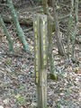
 MST Blaze.jpg 216 × 288; 20 KB
-
 BMP Cliffside Trail steps.JPG 768 × 1,024; 251 KB
-
 BMP Lake Road Bays Ridge Road sign.JPG 3,240 × 4,320; 3.42 MB
-
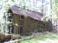 BMP Bill Simpson barn.JPG 1,024 × 768; 301 KB
-
 BMP Cross Ridges Trail profile.JPG 739 × 326; 33 KB
-
 BMP Cliffside Trail profile.JPG 783 × 343; 34 KB
-
 BMP Cliffside Trail view from obs tower towards valley.JPG 336 × 448; 109 KB
-
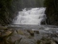 Laurelforkfalls.jpg 300 × 225; 19 KB
-
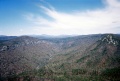 LinvilleGorge.jpg 1,800 × 1,215; 1.15 MB


