Snake Mountain
| |||||||||||||||||||||||||||||||||||||

Trail Overview
I've always called this the "best bang for your buck" hike. It's fairly short, has spectacular views along the way and feels "off the beaten path" even though it is right across the valley from Elk Knob State Park.
Snake Mountain is an Amphibolite mountain north of Boone NC. The mountain has two distinct summits.
North Summit (5,522 ft)
- On the Tennessee / North Carolina line
- It is the high point of Johnson County TN
- 360 degree views
- Summit is marked by a metal spike
South Summit (5,593 ft)
- Highest point of the mountain
- 100% in North Carolina
- Does not have any views
- A little farther south of the summit, there is an open meadow that has great 180 degree views looking west towards Rich Mountain, Grandfather Mountain and the ski areas.
- This open meadow is sometimes mistaken as the south summit
How to get there
Google Maps Driving Directions
Route Description
The parking area is a small gravel lot across from the start of the trail.
There is a large gate that you have to crawl under to start this hike. The gate is not posted Private Property.
| Miles | Snake Mountain | Elevation |
|---|---|---|
| 0.0 miles | Parking Area | 4,218 feet |
| 0.1 miles | Gate | 4,221 feet |
| 0.7 miles | Plaque for Council Main | 4,843 feet |
| 0.85 miles | Metal pole | 5,056 feet |
| 1.0 miles | Arrive at ridgeline. Continue south | 5,282 feet |
| 1.2 miles | North Summit | 5,522 feet |
| 1.75 miles | South Summit | 5,579 feet |
| 1.9 miles | Meadow before dropping off the ridgeline. | 5,523 feet |
| 2.7 miles | Private Home, take driveway down | 4,727 feet |
| 3.0 miles | Back at road, road walk .75 miles back to car | 4,488 feet |
| 3.75 miles | Parking area | 4,218 feet |
Typical Conditions
- The trail conditions vary but for the most part it is rough, rocky, faint, overgrown and sort of feels like a bushwhack.
- I assume it used to be a maintained trail as you can occasionally see old faded yellow blazes but those are few and far between
- Some mild rock scrambling is required especially on the northern section
- The northern ascent to the ridgeline is open field with spectacular views the entire way
- The northern section and ridgeline has lots of clifftops and rock outcrops
- On the way up the northern section, there is some sort of metal pole that you can climb up for a better view if you’re brave
- From the southern meadow on the ridgeline, besides the main trail back to Meat Camp Road, there is also a faint manway down to Rich Mountain Road. Bear in mind that the road walk from Rich Mountain Gap is 4.5 miles back to your car! Probably better done as a shuttle
Fees, Permits, etc.
NOTE The trail over Snake Mountain is almost entirely on private property. The land owners are hiker friendly and there aren't any access issues as of now. Please respect the land so that access will remain open for everyone in the future.
After the Hike
Misc. Information
Maps
Photos
-
 Parking area at the start of hike
 -
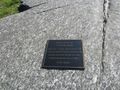 Plaque dedicated to Council Main
 -
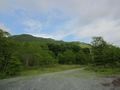
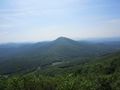
 The view north from the open fields of Snake Mountain. The Peak is the obvious mountain in the distance.
 -
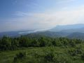
 Looking down the valley between Snake Mountain and Elk Knob. The mountains in the distance hover over Boone NC.
 -
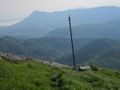 Not sure of the purpose of this pole but it make for a nice subject with a dramatic backdrop.
 -
 Sunalei Preserve. Very large expensive homes on the side of a mountain. Yuck!
 -
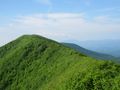
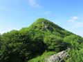 Approaching the North Summit. This is the high point of Johnson County TN.
 -
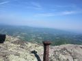 No benchmark but this metal spike marks the summit. 360 degree views!
 -
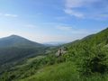
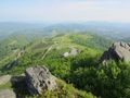
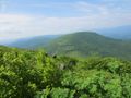
 Looking towards the south summit. Grandfather Mountain, Sugar Mountain and Hanging Rock off in the distance
 -
 Looking across the valley on the ridgeline towards Elk Knob.
 -
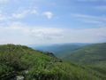
 The meadow after the south summit. Rich Mountain dominates your view here. Grandfather Mountain and the ski areas directly above it in the distance.
 -
 Looking towards the mountains over Boone NC


