There appears to be multiple trail access points. This main trailhead is between the camp store and Cove View campground area, and intersects with the Gorge Ridge Trail. From the cabins area, take the short connectors Buck Rub Trail or Cabin Trail.
The main 2.1 miles of trail wanders up and around the summit. The path has been improved in recent years with several switchbacks to eliminate straight up the hill approaches. It also has a couple of benches at intersections with the access trails.
Once up the hill, there a small shelter (useful during the cold rain) and bench on the loop. Take a right (counter-clockwise) to reach the wood overlook structure on the northwest side. A slot in the forest has been cut to give a view down to the main tunnel. If your timing is great, then a train will be coming through the tunnel.
Continue around the loop to reach the junction for the main trail to return back to trailhead. Alternatively, take the short Cabin Trail over to the roadway for the walk back. This latter makes an easy 3.25 mile total distance.
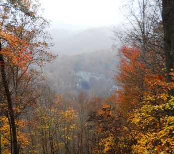
Hard packed dirt - shared with bikes, so be alert. A walk through hardwood forest, so come in the spring for wildflowers and fall for the leaf color.
Daily parking fee for passenger vehicles into VA state parks is $2 weekdays, $3 weekends. Bring exact change.
Visit the camp store for ice cream or a soda. Check out the park visitors center.
Loading map...
{"type":"TERRAIN","minzoom":false,"maxzoom":false,"types":["ROADMAP","SATELLITE","HYBRID","TERRAIN"],"mappingservice":"googlemaps3","width":"auto","height":"500px","centre":{"text":"","title":"","link":"","lat":36.69850000000000278532752417959272861480712890625,"lon":-82.73799999999999954525264911353588104248046875,"icon":""},"title":"","label":"","icon":"","lines":[],"polygons":[],"circles":[],"rectangles":[],"copycoords":false,"static":false,"visitedicon":"","wmsoverlay":false,"zoom":15,"layers":[],"controls":["pan","zoom","type","scale","streetview","rotate"],"zoomstyle":"DEFAULT","typestyle":"DEFAULT","autoinfowindows":false,"resizable":false,"kmlrezoom":false,"poi":true,"cluster":false,"clustergridsize":60,"clustermaxzoom":20,"clusterzoomonclick":true,"clusteraveragecenter":true,"clusterminsize":2,"imageoverlays":[],"kml":[],"gkml":["https://tehcc.org/clubwiki/kml/Natural_Tunnel_SP_-_Purchase_Ridge_Trail.kml","https://tehcc.org/clubwiki/kml/Natural_Tunnel_SP_-_Cabin_Trail.kml"],"searchmarkers":"","fullscreen":false,"mylocation":false,"mylocationfollow":false,"mylocationzoom":-1,"scrollwheelzoom":false,"locations":[{"text":"\u003Cdiv class=\"mw-parser-output\"\u003E\u003Cp\u003EParking at campground trailhead\n\u003C/p\u003E\u003C/div\u003E","title":"Parking at campground trailhead\n","link":"","lat":36.70277999999999707370079704560339450836181640625,"lon":-82.737750000000005456968210637569427490234375,"icon":"/clubwiki/images/MarkerA.png"},{"text":"\u003Cb\u003E\u003Cdiv class=\"mw-parser-output\"\u003E\u003Cp\u003EOverlook\n\u003C/p\u003E\u003C/div\u003E\u003C/b\u003E\u003Cdiv class=\"mw-parser-output\"\u003E\u003Cp\u003E\u003Cspan typeof=\"mw:File\"\u003E\u003Ca href=\"/wiki/File:NTSP_-_Purchase_Ridge_Overlook2.JPG\" class=\"mw-file-description\"\u003E\u003Cimg src=\"/clubwiki/images/thumb/NTSP_-_Purchase_Ridge_Overlook2.JPG/150px-NTSP_-_Purchase_Ridge_Overlook2.JPG\" decoding=\"async\" width=\"150\" height=\"82\" srcset=\"/clubwiki/images/thumb/NTSP_-_Purchase_Ridge_Overlook2.JPG/225px-NTSP_-_Purchase_Ridge_Overlook2.JPG 1.5x, /clubwiki/images/thumb/NTSP_-_Purchase_Ridge_Overlook2.JPG/300px-NTSP_-_Purchase_Ridge_Overlook2.JPG 2x\" data-file-width=\"448\" data-file-height=\"244\" /\u003E\u003C/a\u003E\u003C/span\u003E\n\u003C/p\u003E\u003C/div\u003E","title":"Overlook\n","link":"","lat":36.6938499999999976353137753903865814208984375,"lon":-82.744900000000001227817847393453121185302734375,"icon":"/clubwiki/images/MarkerE.png"},{"text":"","title":"","link":"","lat":36.6977499999999992041921359486877918243408203125,"lon":-82.739429999999998699422576464712619781494140625,"icon":"/clubwiki/images/MarkerK.png"},{"text":"\u003Cdiv class=\"mw-parser-output\"\u003E\u003Cp\u003E0.5 Mile Marker and Bench\n\u003C/p\u003E\u003C/div\u003E","title":"0.5 Mile Marker and Bench\n","link":"","lat":36.696629999999998972270986996591091156005859375,"lon":-82.73845000000000027284841053187847137451171875,"icon":"/clubwiki/images/MarkerK.png"},{"text":"","title":"","link":"","lat":36.695120000000002846718416549265384674072265625,"lon":-82.7407299999999992223820299841463565826416015625,"icon":"/clubwiki/images/MarkerK.png"}]}
