Overlook
| Overlook (log in to submit report) | |
|---|---|

| |
| Park | Warriors' Path State Park |
| Located | Kingsport, TennesseeLocation inherited from associated park |
| Trail Marking | None |
| Trail UseThings allowed to do on or near the trail | |
| FeaturesThings to see on or near the trail |
|
| Difficulty Rating | Easy |
| Hiking TimeTime from car and back. Includes any time hiking to access this trail. | 30 min0.5 Hours <br />0.0313 Days <br /> round trip |
| Distance: | 0.73 mi1.175 km <br /> trailStrict non-repeating trail length / 1.46 mi2.35 km <br /> round tripTypical or shortest length from the car, hike the trail, and return to car |
| Trail Type | In-and-Out |
| Low / High Point | 1,289 ft429.667 Yards <br />392.887 Meters <br /> / 1,401 ft467 Yards <br />427.025 Meters <br /> |
| Elev. Gain/LossSee link for details of calculation. Gain/Loss is direction dependent. | 73 ft22.25 Meters <br /> / (86 ft26.213 Meters <br />) – East-to-West |
| Trip ReportsFrom user "hiked it" submissions<br />Recent is within last 90 days | 6 logged hikes (0 recent) |
| NearbyWithin 5 mi<br />Click link to view list | 24 trails / 18.8 mi of trail |
| Parking | 36° 29' 25.01" N, 82° 28' 37.85" W Map |
| Trailhead | 36° 29' 25.01" N, 82° 28' 37.85" W Map |
|
| |
| Show In Google Maps | |
Trail Overview[edit]
Located in Warriors' Path State Park. Can be hiked as a short loop to the overlooks or as a long loop utilizing the disc golf course. Overlooks have nice views of lake and Interstate 81 bridge.
How to get there[edit]
Directions to main entrance found on Warriors Path State Park webpage.
- Follow the main park road as it winds past the pool, campground, and turnoff for Duck Island.
- Take left towards the fishing piers, but continue back to the boat ramp.
- Park at the far (east) side of the soccer fields.
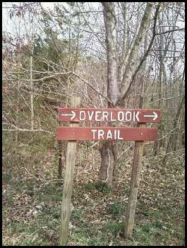
- Sign for trailhead can be seen nearby.
Warning: This area will be very busy during soccer and boating seasons.
Route Description[edit]
Trailhead appears to be a different location than what indicated on park map. Follow the light green blazed trail. There are many spur trails created from the neighborhood and disc golf course.
Double trail route to the overlooks with many connector trails in between. Trail eventually connects with the Domtar Cabin overlooking the lake. Trail then loops along back park boundary where you are literately looking into peoples back yards. Trail ends at Frisbee golf course.
The following hike detail describes hiking the loop in a clockwise direction.
| Distance | Overlook Trail |
|---|---|
| 0.00 mi | Parking at trailhead by chain gate. Head left into the woods. |
| 230 ft | Split. Main trail continues ahead while unmarked spur heads left for more view of the lake and rejoins later. |
| 370 ft | Spur trail rejoins. |
| 0.22 mi | Spur trail to first overlook. |
| 0.26 mi | Split in blazed trail for loop. Most will continue straight for main overlook. |
| 0.32 mi | Double blaze. Head right up RR tie stairs. Straight is unmarked spur trail into neighborhood. |
| 0.36 mi | Keep right. Spur into neighborhood. |
| 0.44 mi | Double blaze. Left heads to disc golf course. Right to continue on trail. |
| 0.48 mi | Return to start of loop. Turn left for trailhead. |
| 0.52 mi | Slight right for trail through woods. |
| 0.80 mi | Back at trailhead. |
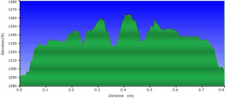
- Below trail profile for walking the loop clockwise. Note only 100 ft elevation scale, thus easy.
Typical Conditions[edit]
Heavily used park trail is generally wide and kept open of the blowdowns (mostly pine dying due to the bore beetle).
Fees, Permits, etc.[edit]
No fee required.
After the Hike[edit]
For families with pre-school to early elementary children, the Darrell's Dream boundless playground offers many ways to burn off excess energy.
