Old Dug Trail
| Old Dug Trail (log in to submit report) | |
|---|---|
| Highlight | A gently graded trail starting in mature forest and ascending through thick rhododendron with occasional mountain laurel. The trail affords sweeping views of Holston Valley with Clinch Mountain and Bays Mountain in the distance. |
| Trail Number | FS #43 |
| Land Owner | Cherokee National Forest |
| Located | Elizabethton, Bristol |
| Trail Marking | None |
| Trail UseThings allowed to do on or near the trail |
|
| FeaturesThings to see on or near the trail |
|
| Difficulty Rating | Medium |
| Hiking TimeTime from car and back. Includes any time hiking to access this trail. | 3.5 hrs0.219 Days <br />210 Min <br /> round trip |
| Distance: | 3.1 mi4.989 km <br /> trailStrict non-repeating trail length / 6.2 mi9.978 km <br /> round tripTypical or shortest length from the car, hike the trail, and return to car |
| Trail Type | In-and-Out |
| Low / High Point | 2,320 ft773.333 Yards <br />707.136 Meters <br /> / 3,360 ft1,120 Yards <br />1,024.128 Meters <br /> |
| Elev. Gain/LossSee link for details of calculation. Gain/Loss is direction dependent. | 1000 ft304.8 Meters <br /> / (40 ft12.192 Meters <br />) – West-to-East |
| Trip ReportsFrom user "hiked it" submissions<br />Recent is within last 90 days | No hikes logged yet |
| NearbyWithin 5 mi<br />Click link to view list | 1 trails / 2.3 mi of trail |
| Parking | 36° 25' 37.56" N, 82° 10' 31.08" W Map |
| Trailhead | 36° 25' 38.64" N, 82° 10' 26.04" W Map |
|
| |
| Show In Google Maps | |
Download KML / Upload new version / KML File Page / GeoJson Page / Create Profile Chart / gpsvisualizer Map
Trail Overview
A hike up the west side of Holston Mountain following an old logging road. The gentle grade and modest elevation gain make for an easy path to the top of Holston Mountain. This trail sees little use because of uncertain condition of the access roads. It can be approached from Elizabethton or Bristol but both accesses involve muddy, rutted roads that require four-wheel drive. The northwest side of Holston Mountain is open to hunting. Wear blaze orange during deer season.
How to get there
From Kingsport, TN:
- Take I-26 south to Exit 24 for US-321 towards Elizabethton.
- Continue through Elizabethton.
- Take left onto US-19E.
- After about 3 miles turn right onto Holston Mountain Road/Flatwoods Road.
- A couple of miles up the hollow, the paved roadway splits with Big Creek Road (no sign) heading to the right. Note: The USFS road is open to the trailhead. Travel about 6 miles on unpaved. A short distance before reaching the parking area the road is again paved. This stretch of old paved road extends beyond the parking area.
- Parking is on right with room for 6 cars. There is a gated Forest Service road at the parking area. February of 2026 the gate was open and you could drive up to the trailhead. The trail is on the right about 500 ft from the parking area.
The parking area can also be reached from the Bristol/Bluff City end of Big Creek Road. This section has the same problem with ruts and mud. About a mile before reaching the parking area from this end, there is a section of old paved road that is still in good shape.
Route Description
| Miles | Feature | Elevation |
|---|---|---|
| 0.0 miles | Parking Area | 2,300 feet |
| 0.4 miles | Intersection with FS road | 2,366 feet |
| 0.75 miles | Continue heading up | 2,360 feet |
| 1.4 miles | Overlook | 2,960 feet |
| 3.1 miles | Intersect with Holston Mountain Trail West | 3.360 feet |
Typical Conditions
The trail is an old logging road which winds up the mountain. The lower trailhead is marked with a Forest Service sign post. tTere is another Forest Service sign at the top marking the junction of Old Dug with Holston Mt. West Trail. Only a few faint trail blazes are left but the trail path is obvious. The soil is sandy and even in wet weather there is little mud.
February 19, 2026 update: The trail is cleared and in good shape all the way to the top. Since Hurricane Helene, the USFS and Southern Appalachian Wilderness Society (SAWS) have cleared all blowdowns. Rhododendron have been cut back on most of the trail.
Fees, Permits, etc.
Located in Cherokee National Forest. No fee to hike the trail.
After the Hike
Misc. Information
Cherokee National Forest allows hunting, thus wear blaze orange during all hunting seasons. In September 2017, one group tracking squirrels were met, while another pair reported chasing a bear cub up the mountain.
Photos
-
 Upper Trailhead, Junction with Holston Mt Trail West
 -
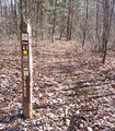 Lower Trailhead Marker

