ClubWiki:Garmin File Access Devices
This documentation is based on usage for the Garmin eTrex 10. It is likely similar to other Garmin GPS devices not only the eTrex line but specifically those that permit direct access to GPX files. Simply, if you plug the USB based device in to your computer, if you can access the file contents, you will likely use the same retrieval method.
Configuration[edit]
Any specific desired configuration will be noted here. At this time, none are known and should work for track and waypoint purposes "out of the box."
Logging Usage[edit]
This section describes using a Garmin eTrex device for waypoint and track recording.
Tracks[edit]
Tracks are automatically tracked and created by simply powering on/off the device.
As of this time, I haven't explored the device enough to know if more control over track logging starting/stopping is possible.
Waypoints[edit]
Waypoints are added by simply accessing the Menu and find "Add Waypoint"
Data Retrieval[edit]
This describes getting the waypoints and tracks (paths in Google Earth parlance) off the device and onto your computer.
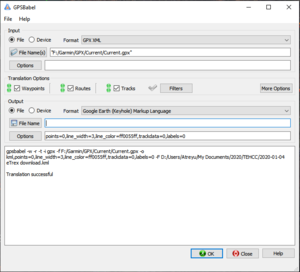
- Connect the device
- Launch GPSBabel
- For Input, set to File and Format "GPX XML" and using File Name(s) navigate on to the device to "Garmin\GPX\Current\Current.gpx"
- Select in Translation Options Waypoints, Routes, and Tracks
- For Output, set to File and Format "Google Earth (Keyhole) Markup Language"
- Provide a File Name to save to - I typically use "Date - eTrex Download.kml"
- Optionally, set options to a width of 3 pixels and a color of "ff0055ff" which should be opaque orange (adjust as desired, but the default is a translucent cyan)
- Hit OK and look for output that finishes with "Translation successful"
You should now have the KML file for opening in Google Earth. Return to Creating a Trail KML for additional manipulation.
