Loading map...
{"format":"googlemaps3","type":"TERRAIN","minzoom":false,"maxzoom":false,"types":["SATELLITE","HYBRID","TERRAIN"],"limit":50,"offset":0,"link":"none","sort":[""],"order":[],"headers":"show","mainlabel":"","intro":"","outro":"","searchlabel":"... further results","default":"","import-annotation":false,"width":"auto","height":"600px","centre":false,"title":"","label":"","icon":"","lines":[],"polygons":[],"circles":[],"rectangles":[],"copycoords":false,"static":false,"visitedicon":"","wmsoverlay":false,"zoom":false,"layers":[],"controls":["pan","zoom","type","scale","streetview","rotate"],"zoomstyle":"DEFAULT","typestyle":"DEFAULT","autoinfowindows":false,"resizable":false,"kmlrezoom":true,"poi":true,"cluster":false,"clustergridsize":60,"clustermaxzoom":20,"clusterzoomonclick":true,"clusteraveragecenter":true,"clusterminsize":2,"imageoverlays":[],"kml":[],"gkml":["https://tehcc.org/clubwiki/images/Gentry_Creek_Falls.kml","https://tehcc.org/clubwiki/images/Rogers_Ridge_Horse_Trail.kml"],"searchmarkers":"","fullscreen":false,"scrollwheelzoom":false,"showtitle":false,"hidenamespace":true,"template":"Map Balloon Template","userparam":"","activeicon":"","pagelabel":false,"ajaxcoordproperty":"","ajaxquery":"","locations":[{"text":"\u003Cp\u003E\u003Cb\u003E\u003Ca class=\"mw-selflink selflink\"\u003EGentry Creek Falls\u003C/a\u003E\u003C/b\u003E\u003Cbr /\u003E\u003C/p\u003E\u003Chr /\u003E\u003Cp\u003E2.30\u0026#160;Mi (3.70\u0026#160;km)\u003Cbr /\u003EDifficulty: Medium\u003Cbr /\u003EMarking: Blue\u003C/p\u003E","title":"Gentry Creek Falls","link":"","lat":36.54261000000000336740413331426680088043212890625,"lon":-81.73466999999999416104401461780071258544921875,"icon":"/clubwiki/images/MarkerT.png"},{"text":"\u003Cp\u003E\u003Cb\u003ETrailhead\u003C/b\u003E\u003Cbr /\u003E\u003C/p\u003E\u003Chr /\u003E\u003Cp\u003ETrailhead\u003C/p\u003E","title":"Gentry Creek Falls","link":"","lat":36.54224602680000089094392023980617523193359375,"lon":-81.7245300489999948467811918817460536956787109375,"icon":"/clubwiki/images/MarkerT.png"},{"text":"\u003Cp\u003E\u003Cb\u003EGentry Creek Falls\u003C/b\u003E\u003Cbr /\u003E\u003C/p\u003E\u003Chr /\u003E\u003Cp\u003EGentry Creek Falls\u003C/p\u003E","title":"Gentry Creek Falls","link":"","lat":36.56770000000000209183781407773494720458984375,"lon":-81.705749999999994770405464805662631988525390625,"icon":"/clubwiki/images/MarkerC.png"},{"text":"\u003Cp\u003E\u003Cb\u003E\u003Ca href=\"/wiki/Rogers_Ridge_Horse_Trail\" title=\"Rogers Ridge Horse Trail\"\u003ERogers Ridge Horse Trail\u003C/a\u003E\u003C/b\u003E\u003Cbr /\u003E\u003C/p\u003E\u003Chr /\u003E\u003Cp\u003E6.81\u0026#160;Mi (10.96\u0026#160;km)\u003Cbr /\u003EDifficulty: Medium\u003Cbr /\u003EMarking: Yellow\u003C/p\u003E","title":"Rogers Ridge Horse Trail","link":"","lat":36.54500999999999777401171741075813770294189453125,"lon":-81.7383899999999954388840706087648868560791015625,"icon":"/clubwiki/images/MarkerT.png"},{"text":"\u003Cp\u003E\u003Cb\u003EUnknown trail connection\u003C/b\u003E\u003Cbr /\u003E\u003C/p\u003E\u003Chr /\u003E\u003Cp\u003EUnknown trail connection\u003C/p\u003E","title":"Rogers Ridge Horse Trail","link":"","lat":36.5687750000000022509993868879973888397216796875,"lon":-81.712323999999995294274413026869297027587890625,"icon":"/clubwiki/images/MarkerT.png"},{"text":"\u003Cp\u003E\u003Cb\u003ERogers Ridge Horse Trail\u003C/b\u003E\u003Cbr /\u003E\u003C/p\u003E\u003Chr /\u003E\u003Cp\u003ERogers Ridge Horse Trail\u003C/p\u003E","title":"Rogers Ridge Horse Trail","link":"","lat":36.54500600000000076761352829635143280029296875,"lon":-81.7383909999999929141267784871160984039306640625,"icon":"/clubwiki/images/MarkerT.png"},{"text":"\u003Cp\u003E\u003Cb\u003ETrail connection\u003C/b\u003E\u003Cbr /\u003E\u003C/p\u003E\u003Chr /\u003E\u003Cp\u003E\u003Ca href=\"/wiki/File:Rogers_Ridge_Possible_Terminus.jpg\" class=\"image\" title=\"Possible official Rogers Ridge Terminus?\"\u003E\u003Cimg alt=\"Possible official Rogers Ridge Terminus?\" src=\"/clubwiki/images/thumb/Rogers_Ridge_Possible_Terminus.jpg/150px-Rogers_Ridge_Possible_Terminus.jpg\" decoding=\"async\" width=\"150\" height=\"200\" srcset=\"/clubwiki/images/thumb/Rogers_Ridge_Possible_Terminus.jpg/225px-Rogers_Ridge_Possible_Terminus.jpg 1.5x, /clubwiki/images/thumb/Rogers_Ridge_Possible_Terminus.jpg/300px-Rogers_Ridge_Possible_Terminus.jpg 2x\" data-file-width=\"768\" data-file-height=\"1024\" /\u003E\u003C/a\u003E\u003C/p\u003E","title":"Rogers Ridge Horse Trail","link":"","lat":36.583652999999998201019479893147945404052734375,"lon":-81.6952500000000014779288903810083866119384765625,"icon":"/clubwiki/images/MarkerT.png"},{"text":"\u003Cp\u003E\u003Cb\u003E\u003Ca href=\"/wiki/File:Rogers_Ridge_Hitching_Posts.jpg\" class=\"image\" title=\"Camping spot and horse hitching posts\"\u003E\u003Cimg alt=\"Camping spot and horse hitching posts\" src=\"/clubwiki/images/thumb/Rogers_Ridge_Hitching_Posts.jpg/150px-Rogers_Ridge_Hitching_Posts.jpg\" decoding=\"async\" width=\"150\" height=\"113\" srcset=\"/clubwiki/images/thumb/Rogers_Ridge_Hitching_Posts.jpg/225px-Rogers_Ridge_Hitching_Posts.jpg 1.5x, /clubwiki/images/thumb/Rogers_Ridge_Hitching_Posts.jpg/300px-Rogers_Ridge_Hitching_Posts.jpg 2x\" data-file-width=\"1280\" data-file-height=\"960\" /\u003E\u003C/a\u003E\u003C/b\u003E\u003Cbr /\u003E\u003C/p\u003E\u003Chr /\u003E\u003Cp\u003E\u003Ca href=\"/wiki/File:Rogers_Ridge_Hitching_Posts.jpg\" class=\"image\" title=\"Camping spot and horse hitching posts\"\u003E\u003Cimg alt=\"Camping spot and horse hitching posts\" src=\"/clubwiki/images/thumb/Rogers_Ridge_Hitching_Posts.jpg/150px-Rogers_Ridge_Hitching_Posts.jpg\" decoding=\"async\" width=\"150\" height=\"113\" srcset=\"/clubwiki/images/thumb/Rogers_Ridge_Hitching_Posts.jpg/225px-Rogers_Ridge_Hitching_Posts.jpg 1.5x, /clubwiki/images/thumb/Rogers_Ridge_Hitching_Posts.jpg/300px-Rogers_Ridge_Hitching_Posts.jpg 2x\" data-file-width=\"1280\" data-file-height=\"960\" /\u003E\u003C/a\u003E\u003C/p\u003E","title":"Rogers Ridge Horse Trail","link":"","lat":36.58836699999999808596840011887252330780029296875,"lon":-81.6886729999999943174771033227443695068359375,"icon":"/clubwiki/images/MarkerH.png"},{"text":"\u003Cp\u003E\u003Cb\u003EOverlook\u003C/b\u003E\u003Cbr /\u003E\u003C/p\u003E\u003Chr /\u003E\u003Cp\u003E\u003Ca href=\"/wiki/File:Rogers_Ridge_Balds_View_4.jpg\" class=\"image\" title=\"View from the balds\"\u003E\u003Cimg alt=\"View from the balds\" src=\"/clubwiki/images/thumb/Rogers_Ridge_Balds_View_4.jpg/150px-Rogers_Ridge_Balds_View_4.jpg\" decoding=\"async\" width=\"150\" height=\"113\" srcset=\"/clubwiki/images/thumb/Rogers_Ridge_Balds_View_4.jpg/225px-Rogers_Ridge_Balds_View_4.jpg 1.5x, /clubwiki/images/thumb/Rogers_Ridge_Balds_View_4.jpg/300px-Rogers_Ridge_Balds_View_4.jpg 2x\" data-file-width=\"1280\" data-file-height=\"960\" /\u003E\u003C/a\u003E\u003C/p\u003E","title":"Rogers Ridge Horse Trail","link":"","lat":36.58883399999999852525434107519686222076416015625,"lon":-81.6903219999999947731339489109814167022705078125,"icon":"/clubwiki/images/MarkerE.png"},{"text":"\u003Cp\u003E\u003Cb\u003EBalds clearing\u003C/b\u003E\u003Cbr /\u003E\u003C/p\u003E\u003Chr /\u003E\u003Cp\u003E\u003Ca href=\"/wiki/File:Rogers_Ridge_Balds_Hiking.jpg\" class=\"image\" title=\"View of the balds\"\u003E\u003Cimg alt=\"View of the balds\" src=\"/clubwiki/images/thumb/Rogers_Ridge_Balds_Hiking.jpg/150px-Rogers_Ridge_Balds_Hiking.jpg\" decoding=\"async\" width=\"150\" height=\"113\" srcset=\"/clubwiki/images/thumb/Rogers_Ridge_Balds_Hiking.jpg/225px-Rogers_Ridge_Balds_Hiking.jpg 1.5x, /clubwiki/images/thumb/Rogers_Ridge_Balds_Hiking.jpg/300px-Rogers_Ridge_Balds_Hiking.jpg 2x\" data-file-width=\"1280\" data-file-height=\"960\" /\u003E\u003C/a\u003E\u003C/p\u003E","title":"Rogers Ridge Horse Trail","link":"","lat":36.58319399999999887995727476663887500762939453125,"lon":-81.69472700000000031650415621697902679443359375,"icon":"/clubwiki/images/MarkerG.png"},{"text":"\u003Cp\u003E\u003Cb\u003EMulti-(Unknown)Trail Junction\u003C/b\u003E\u003Cbr /\u003E\u003C/p\u003E\u003Chr /\u003E\u003Cp\u003EMulti-(Unknown)Trail Junction\u003C/p\u003E","title":"Rogers Ridge Horse Trail","link":"","lat":36.5727509999999966794348438270390033721923828125,"lon":-81.710385000000002264641807414591312408447265625,"icon":"/clubwiki/images/MarkerT.png"},{"text":"\u003Cp\u003E\u003Cb\u003EUnknown trail connection\u003C/b\u003E\u003Cbr /\u003E\u003C/p\u003E\u003Chr /\u003E\u003Cp\u003EUnknown trail connection\u003C/p\u003E","title":"Rogers Ridge Horse Trail","link":"","lat":36.5711909999999988940544426441192626953125,"lon":-81.71098100000000385989551432430744171142578125,"icon":"/clubwiki/images/MarkerT.png"},{"text":"\u003Cp\u003E\u003Cb\u003EUnknown trail connection\u003C/b\u003E\u003Cbr /\u003E\u003C/p\u003E\u003Chr /\u003E\u003Cp\u003EUnknown trail connection\u003C/p\u003E","title":"Rogers Ridge Horse Trail","link":"","lat":36.54892099999999999226929503493010997772216796875,"lon":-81.7299249999999943838702165521681308746337890625,"icon":"/clubwiki/images/MarkerT.png"},{"text":"\u003Cp\u003E\u003Cb\u003ETrail high point\u003C/b\u003E\u003Cbr /\u003E\u003C/p\u003E\u003Chr /\u003E\u003Cp\u003ETrail high point\u003C/p\u003E","title":"Rogers Ridge Horse Trail","link":"","lat":36.58747699999999980491338646970689296722412109375,"lon":-81.68295299999999770079739391803741455078125,"icon":"/clubwiki/images/MarkerD.png"},{"text":"\u003Cp\u003E\u003Cb\u003EUnknown trail connection\u003C/b\u003E\u003Cbr /\u003E\u003C/p\u003E\u003Chr /\u003E\u003Cp\u003EPossibly to B\u0026amp;B\u003C/p\u003E","title":"Rogers Ridge Horse Trail","link":"","lat":36.5465879999999998517523636110126972198486328125,"lon":-81.7368709999999936144376988522708415985107421875,"icon":"/clubwiki/images/MarkerT.png"},{"text":"\u003Cp\u003E\u003Cb\u003EOverlook\u003C/b\u003E\u003Cbr /\u003E\u003C/p\u003E\u003Chr /\u003E\u003Cp\u003E\u003Ca href=\"/wiki/File:Rogers_Ridge_Balds_View_1.jpg\" class=\"image\" title=\"View of the trail\"\u003E\u003Cimg alt=\"View of the trail\" src=\"/clubwiki/images/thumb/Rogers_Ridge_Balds_View_1.jpg/150px-Rogers_Ridge_Balds_View_1.jpg\" decoding=\"async\" width=\"150\" height=\"113\" srcset=\"/clubwiki/images/thumb/Rogers_Ridge_Balds_View_1.jpg/225px-Rogers_Ridge_Balds_View_1.jpg 1.5x, /clubwiki/images/thumb/Rogers_Ridge_Balds_View_1.jpg/300px-Rogers_Ridge_Balds_View_1.jpg 2x\" data-file-width=\"1280\" data-file-height=\"960\" /\u003E\u003C/a\u003E\u003C/p\u003E","title":"Rogers Ridge Horse Trail","link":"","lat":36.58156799999999719830157118849456310272216796875,"lon":-81.696920000000005757101462222635746002197265625,"icon":"/clubwiki/images/MarkerE.png"},{"text":"\u003Cp\u003E\u003Cb\u003EUnknown trail connection in clearing\u003C/b\u003E\u003Cbr /\u003E\u003C/p\u003E\u003Chr /\u003E\u003Cp\u003EUnknown trail connection in clearing\u003C/p\u003E","title":"Rogers Ridge Horse Trail","link":"","lat":36.57638899999999892997948336414992809295654296875,"lon":-81.7026259999999950878191157244145870208740234375,"icon":"/clubwiki/images/MarkerT.png"},{"text":"\u003Cp\u003E\u003Cb\u003EUnknown trail connection\u003C/b\u003E\u003Cbr /\u003E\u003C/p\u003E\u003Chr /\u003E\u003Cp\u003EPossibly to reach the balds sooner\u003C/p\u003E","title":"Rogers Ridge Horse Trail","link":"","lat":36.57976699999999681267581763677299022674560546875,"lon":-81.6957879999999931897036731243133544921875,"icon":"/clubwiki/images/MarkerT.png"},{"text":"\u003Cp\u003E\u003Cb\u003ECamping spots\u003C/b\u003E\u003Cbr /\u003E\u003C/p\u003E\u003Chr /\u003E\u003Cp\u003ECamping spots\u003C/p\u003E","title":"Rogers Ridge Horse Trail","link":"","lat":36.5779009999999971114448271691799163818359375,"lon":-81.7012849999999986039256327785551548004150390625,"icon":"/clubwiki/images/MarkerH.png"},{"text":"\u003Cp\u003E\u003Cb\u003Etriangulation station disk for NC-TN-VA Corner\u003C/b\u003E\u003Cbr /\u003E\u003C/p\u003E\u003Chr /\u003E\u003Cp\u003E\u003Ca href=\"/wiki/File:NC-VA-TN_Corner_triangulation_station_disk.jpg\" class=\"image\" title=\"Triangulation Disk at TN-VA-NC Corner\"\u003E\u003Cimg alt=\"Triangulation Disk at TN-VA-NC Corner\" src=\"/clubwiki/images/thumb/NC-VA-TN_Corner_triangulation_station_disk.jpg/150px-NC-VA-TN_Corner_triangulation_station_disk.jpg\" decoding=\"async\" width=\"150\" height=\"113\" srcset=\"/clubwiki/images/thumb/NC-VA-TN_Corner_triangulation_station_disk.jpg/225px-NC-VA-TN_Corner_triangulation_station_disk.jpg 1.5x, /clubwiki/images/thumb/NC-VA-TN_Corner_triangulation_station_disk.jpg/300px-NC-VA-TN_Corner_triangulation_station_disk.jpg 2x\" data-file-width=\"600\" data-file-height=\"450\" /\u003E\u003C/a\u003E\u003C/p\u003E","title":"Rogers Ridge Horse Trail","link":"","lat":36.58816999999999808323991601355373859405517578125,"lon":-81.677449999999993224264471791684627532958984375,"icon":"/clubwiki/images/MarkerG.png"},{"text":"\u003Cp\u003E\u003Cb\u003ETrail/Road Junction\u003C/b\u003E\u003Cbr /\u003E\u003C/p\u003E\u003Chr /\u003E\u003Cp\u003ETrail/Road Junction\u003C/p\u003E","title":"Rogers Ridge Horse Trail","link":"","lat":36.5847710000000034824552130885422229766845703125,"lon":-81.679069999999995843609212897717952728271484375,"icon":"/clubwiki/images/MarkerT.png"},{"text":"\u003Cp\u003E\u003Cb\u003EUnknown trail connection\u003C/b\u003E\u003Cbr /\u003E\u003C/p\u003E\u003Chr /\u003E\u003Cp\u003EUnknown trail connection\u003C/p\u003E","title":"Rogers Ridge Horse Trail","link":"","lat":36.57216199999999872716216486878693103790283203125,"lon":-81.7092789999999951078279991634190082550048828125,"icon":"/clubwiki/images/MarkerT.png"}]}
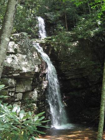
Hike with 13-14 water crossings to double drop waterfall.
Point of information is that the first cul-de-sac parking lot reached on the gravel road is for Rogers Ridge Horse Trail. Veer to the right to continue back to the dead end cul-de-sac with a trail marker for Gentry Creek Falls.
Hikers cross mound barriers. The trail is very gentle rise up a shaded valley with the expected numerous creek crossings using stepping stones. Gentry Creek is pretty with small rapids. The two tiered waterfall is an enjoyable vista for lunch.
Note: The upper falls can be reached by a very narrow path on the right side of the lower falls - but dangerous!
Trail is not regularly maintained, but usually passible. Recent (2014) work by the Cherokee National Forest has resulted in stepping stones at all the creek crossings. Difficulty of creek crossings depends on season and whether recent rains. The crossings are all quite navigable, though hiking poles won't hurt. Lots of mosquitos during summer.
Located in Watauga Ranger District of Cherokee National Forest. Office number is (423) 735-1500. No fee to hike the trail, but state fishing regulations apply to Gentry Creek.
Consider wearing blaze orange during hunting season.
Gentry Creek Falls are named after Joseph Gentry that bought 500 acres along the creek in May of 1802.


