Back Hollow Road
| Back Hollow Road (log in to submit report) | |
|---|---|
| Park | Bays Mountain Park |
| Located | Kingsport, TennesseeLocation inherited from associated park |
| Trail Marking | Signs |
| Trail UseThings allowed to do on or near the trail |
|
| FeaturesThings to see on or near the trail |
|
| Difficulty Rating | Medium |
| Hiking TimeTime from car and back. Includes any time hiking to access this trail. | 30 Min0.5 Hours <br />0.0313 Days <br /> round trip |
| Distance: | 0.92 mi1.481 km <br /> trailStrict non-repeating trail length / 0.92 mi1.481 km <br /> round tripTypical or shortest length from the car, hike the trail, and return to car |
| Trail Type | Loop |
| Low / High Point | 1,297 ft432.333 Yards <br />395.326 Meters <br /> / 1,496 Ft498.667 Yards <br />455.981 Meters <br /> |
| Elev. Gain/LossSee link for details of calculation. Gain/Loss is direction dependent. | 170 Ft51.816 Meters <br /> / (170 Ft51.816 Meters <br />) – Clockwise |
| Trip ReportsFrom user "hiked it" submissions<br />Recent is within last 90 days | 2 logged hikes (0 recent) |
| NearbyWithin 5 mi<br />Click link to view list | 24 trails / 18.6 mi of trail |
| Parking | 36° 30' 14.83" N, 82° 28' 1.85" W Map |
| Trailhead | 36° 30' 14.83" N, 82° 28' 1.85" W Map |
|
| |
| Show In Google Maps | |
Download KML / Upload new version / KML File Page / Create Profile Chart / gpsvisualizer Map
Trail Overview
Located in Bays Mountain Park. Back Hollow Road leads to less used part of the park from Feagins Gap past old cabins and a primitive camping area. The far western part becomes difficult to travel due to blowdowns and a creek that runs in the path.
How to get there
Most will start at Feagins Gap, thus approach from Lake Road.
Route Description
Mostly straight shot down hollow. No blazes.
This trail has connections to Lake Road (Bays Mountain Park), River Mountain Road, Cross Ridges Trail, Pretty Ridge Trail, and Front Hollow Road
| Miles | Back Hollow Road | Elevation (ft) |
|---|---|---|
| 0.00 | Feagins Gap | 1910 |
| 0.56 | Cabin maintained by park | 1720 |
| 0.62 | Primative campsite | 1700 |
| 0.90 | Junction with Pretty Ridge Trail and Cross Ridges Trail | 1675 |
| 1.72 | Barbed wire fence gate | 1640 |
| 1.80 | Junction with Pretty Ridge Trail across field and behind barn. Look for sty over fence. | 1615 |
| 1.86 | Large gate - trail veers left | 1635 |
| 1.95 | Connection with Front Hollow Road in meadow | 1615 |
Mountain biking is only to the primitive campsite, then hiking only.
Typical Conditions
Former gravel road to primitive campsite. Then a dirt road to far west end. While there is a line on the map, that does not mean there is a trail on the ground. Past split to Pretty Ridge Trail has been abandoned by the park, thus no maintenance being done.
Photos
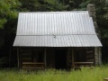
Cabin near primative campsite
