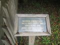
Leaving south on 143, the most direct access is at the shelter before the cabins. This access is mid-way through the trail.
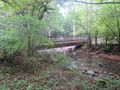
Beginning at a park shelter, this trail begins with either crossing the river for a short hike, or walking along the river until it meets Fred Behrend Trail.
Being a TN state park, the dirt and gravel trails are kept in good condition. Some of the trail sections are steep, thus can be slippery after a rain.
Riverside Trail is shown below in purple since maps don't allow the use of its blaze color white.
Loading map...
{"type":"TERRAIN","minzoom":false,"maxzoom":false,"types":["ROADMAP","SATELLITE","HYBRID","TERRAIN"],"mappingservice":"googlemaps3","width":"auto","height":"550px","centre":{"text":"","title":"","link":"","lat":36.16670599999999780038706376217305660247802734375,"lon":-82.09877000000000180079950951039791107177734375,"icon":""},"title":"","label":"","icon":"","lines":[],"polygons":[],"circles":[],"rectangles":[],"copycoords":false,"static":false,"visitedicon":"","wmsoverlay":false,"zoom":16,"layers":[],"controls":["pan","zoom","type","scale","streetview","rotate"],"zoomstyle":"DEFAULT","typestyle":"DEFAULT","autoinfowindows":false,"resizable":false,"kmlrezoom":false,"poi":true,"cluster":false,"clustergridsize":60,"clustermaxzoom":20,"clusterzoomonclick":true,"clusteraveragecenter":true,"clusterminsize":2,"imageoverlays":[],"kml":[],"gkml":["http://tehcc.org/clubwiki/kml/RMSP_Riverside_Trail.kml","http://tehcc.org/clubwiki/kml/RMSP_Fred_Behrend_Trail.kml"],"searchmarkers":"","fullscreen":false,"scrollwheelzoom":false,"locations":[{"text":"\u003Cdiv class=\"mw-parser-output\"\u003E\u003Cp\u003EConnection with Fred Behrend Trail\n\u003C/p\u003E\u003C/div\u003E","title":"Connection with Fred Behrend Trail\n","link":"","lat":36.163128000000000383806764148175716400146484375,"lon":-82.100052000000005136826075613498687744140625,"icon":"/clubwiki/images/MarkerT.png"},{"text":"\u003Cb\u003E\u003Cdiv class=\"mw-parser-output\"\u003E\u003Cp\u003EBridge to group campsites\n\u003C/p\u003E\u003C/div\u003E\u003C/b\u003E\u003Cdiv class=\"mw-parser-output\"\u003E\u003Cp\u003E\u003Ca href=\"/wiki/File:Roan_Bridge_over_Doe_River.jpg\" class=\"image\" title=\"Bridge to group campsites\"\u003E\u003Cimg alt=\"Bridge to group campsites\" src=\"/clubwiki/images/thumb/Roan_Bridge_over_Doe_River.jpg/150px-Roan_Bridge_over_Doe_River.jpg\" decoding=\"async\" width=\"150\" height=\"113\" srcset=\"/clubwiki/images/thumb/Roan_Bridge_over_Doe_River.jpg/225px-Roan_Bridge_over_Doe_River.jpg 1.5x, /clubwiki/images/thumb/Roan_Bridge_over_Doe_River.jpg/300px-Roan_Bridge_over_Doe_River.jpg 2x\" data-file-width=\"1280\" data-file-height=\"960\" /\u003E\u003C/a\u003E\n\u003C/p\u003E\u003C/div\u003E","title":"Bridge to group campsites\n","link":"","lat":36.16414999999999935198502498678863048553466796875,"lon":-82.098782999999997400664142332971096038818359375,"icon":"/clubwiki/images/MarkerL.png"},{"text":"\u003Cb\u003E\u003Cdiv class=\"mw-parser-output\"\u003E\u003Cp\u003EBridge to boardwalk\n\u003C/p\u003E\u003C/div\u003E\u003C/b\u003E\u003Cdiv class=\"mw-parser-output\"\u003E\u003Cp\u003E\u003Ca href=\"/wiki/File:Builders_of_Roan_bridge.jpg\" class=\"image\" title=\"Builders of the bridge\"\u003E\u003Cimg alt=\"Builders of the bridge\" src=\"/clubwiki/images/thumb/Builders_of_Roan_bridge.jpg/150px-Builders_of_Roan_bridge.jpg\" decoding=\"async\" width=\"150\" height=\"113\" srcset=\"/clubwiki/images/thumb/Builders_of_Roan_bridge.jpg/225px-Builders_of_Roan_bridge.jpg 1.5x, /clubwiki/images/thumb/Builders_of_Roan_bridge.jpg/300px-Builders_of_Roan_bridge.jpg 2x\" data-file-width=\"1280\" data-file-height=\"960\" /\u003E\u003C/a\u003E\n\u003C/p\u003E\u003C/div\u003E","title":"Bridge to boardwalk\n","link":"","lat":36.16572699999999684905560570769011974334716796875,"lon":-82.096530999999998812199919484555721282958984375,"icon":"/clubwiki/images/MarkerL.png"},{"text":"\u003Cb\u003E\u003Cdiv class=\"mw-parser-output\"\u003E\u003Cp\u003EHandicap accessible boardwalk\n\u003C/p\u003E\u003C/div\u003E\u003C/b\u003E\u003Cdiv class=\"mw-parser-output\"\u003E\u003Cp\u003E\u003Ca href=\"/wiki/File:Roan_sign_about_the_wetlands.jpg\" class=\"image\" title=\"About the wetlands\"\u003E\u003Cimg alt=\"About the wetlands\" src=\"/clubwiki/images/thumb/Roan_sign_about_the_wetlands.jpg/150px-Roan_sign_about_the_wetlands.jpg\" decoding=\"async\" width=\"150\" height=\"113\" srcset=\"/clubwiki/images/thumb/Roan_sign_about_the_wetlands.jpg/225px-Roan_sign_about_the_wetlands.jpg 1.5x, /clubwiki/images/thumb/Roan_sign_about_the_wetlands.jpg/300px-Roan_sign_about_the_wetlands.jpg 2x\" data-file-width=\"1280\" data-file-height=\"960\" /\u003E\u003C/a\u003E\n\u003C/p\u003E\u003C/div\u003E","title":"Handicap accessible boardwalk\n","link":"","lat":36.1655659999999983256202540360391139984130859375,"lon":-82.0962339999999954898157739080488681793212890625,"icon":"/clubwiki/images/MarkerG.png"},{"text":"\u003Cdiv class=\"mw-parser-output\"\u003E\u003Cp\u003EBoardwalk ends\n\u003C/p\u003E\u003C/div\u003E","title":"Boardwalk ends\n","link":"","lat":36.1653000000000020008883439004421234130859375,"lon":-82.096352999999993471647030673921108245849609375,"icon":"/clubwiki/images/MarkerG.png"},{"text":"\u003Cdiv class=\"mw-parser-output\"\u003E\u003Cp\u003ETrail head\n\u003C/p\u003E\u003C/div\u003E","title":"Trail head\n","link":"","lat":36.1643040000000013378667063079774379730224609375,"lon":-82.096686000000005378751666285097599029541015625,"icon":"/clubwiki/images/MarkerG.png"}]}