Main Page: Difference between revisions
(updating feature) |
(embiggen the featured photo) |
||
| Line 61: | Line 61: | ||
| style="padding:2px;" | <h2 style="margin:3px; background:#cef2e0; font-family:inherit; font-size:120%; font-weight:bold; border:1px solid #a3bfb1; text-align:left; color:#000; padding:0.2em 0.4em;">Featured Trail</h2> | | style="padding:2px;" | <h2 style="margin:3px; background:#cef2e0; font-family:inherit; font-size:120%; font-weight:bold; border:1px solid #a3bfb1; text-align:left; color:#000; padding:0.2em 0.4em;">Featured Trail</h2> | ||
|- | |- | ||
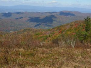
| style="color:#000;" | <div style="padding:2px 5px">[[File:Rogers Ridge Balds View 2.jpg|right|thumb| | | style="color:#000;" | <div style="padding:2px 5px">[[File:Rogers Ridge Balds View 2.jpg|right|thumb|300px|Rogers Ridge Balds View]][[Rogers Ridge Horse Trail]] is an in-and-out 6.87-mile ridgeline trail. It's a long hill climb trail for a day hike, but near the end, the 360° views of the surrounding ridgelines make it all worthwhile. A side benefit of this hike is being able to reach the Tri-State Corner Knob junction of TN-NC-VA. The trail begins in the Horse Ridge Scenic Area of the Cherokee National Forest past Damascus near Laurel Bloomery, TN. Horses are allowed, but on a recent October 2015 trip, there was little evidence of them. Although clearly marked at the trail head that ATV/ORV vehicles were not allowed, signs of their recent presence were along the entire trail. | ||
The hike begins with an immediate creek crossing that has neither a bridge nor decent rocks to hop across; but this will be the last time you see water. Although guide books mention some campsites along the way with water access, we didn't see them. The trail wastes no time getting to the 3,201 feet of climbing, as it's nearly a consistent slope up to the summit. The trail itself is very well marked with yellow rectangle blazes, but several unmarked and well worn trails connect along the way. It may be that one of them connects to the [[Gentry Creek Falls]] trail that would make for a nice loop trail. The trail itself is wide with a clear "two-track" appearance and the occasional water-logged rut to walk around. While not noticed on the ascent, the descent can be challenging for the ankles, as there are several sections of loose rocks, fist-sized and smaller. | The hike begins with an immediate creek crossing that has neither a bridge nor decent rocks to hop across; but this will be the last time you see water. Although guide books mention some campsites along the way with water access, we didn't see them. The trail wastes no time getting to the 3,201 feet of climbing, as it's nearly a consistent slope up to the summit. The trail itself is very well marked with yellow rectangle blazes, but several unmarked and well worn trails connect along the way. It may be that one of them connects to the [[Gentry Creek Falls]] trail that would make for a nice loop trail. The trail itself is wide with a clear "two-track" appearance and the occasional water-logged rut to walk around. While not noticed on the ascent, the descent can be challenging for the ankles, as there are several sections of loose rocks, fist-sized and smaller. | ||
Revision as of 10:30, 2 November 2015
Welcome to Tennessee Eastman Hiking and Canoeing Club's Trail WIKI
Our online repository for everything trail related within a reasonable distance from our club's center in Kingsport TN.
| Trails by area | Trails by use | Trails by features | Other ways to find trails | Information |
|---|---|---|---|---|
|
|
|
TEHCC Fall EXPO - November 14th - Wiki Discussion |
|---|
| Attend our Fall 2015 Expo!
In the midst of our day of hiking, paddling, chili, gear, etc. from 4:00pm to 7:00pm at the Eastman Lodge near Bays Mountain we'll have a table set up for discussions about our trail wiki. The talk is unstructured and we can discuss anything from how to use the site, to how to edit, to an open discussion on plans for the future. There will also be a Bays Structure Tour hike beginning at 8:30a at the park dam. Come and see how the trail details are collected and then entered into the site. For more details visit our main site. Members and non/prospective-members are welcome at this or any of the day's events. Advance reservations aren't required for any events, but appreciated for planning purposes. Paid reservations only required for those wishing to partake in the chili, drinks, sides, and desserts. Paid entrance into Bays Mountain Park is required unless prior car pooling arrangements are made. |
|
|
Currently there are 52 trails documented on our wiki!


