User talk:Tim: Difference between revisions
Jump to navigation
Jump to search
(→Upload KML?: answering Tndude) |
|||
| Line 10: | Line 10: | ||
--[[User:Tndude|Tndude]] ([[User talk:Tndude|talk]]) 09:28, 28 October 2015 (EDT) | --[[User:Tndude|Tndude]] ([[User talk:Tndude|talk]]) 09:28, 28 October 2015 (EDT) | ||
:We upload them, then use the map plugin to reference them. I had a problem figuring out how to upload them within the wiki yet still have the maps plugin be able to see them. That was several versions ago of Mediawiki and a different mapping plugin so it might not be a problem anymore. I'll do some checking. In the meantime you can either [mailto:tim@tehcc.org email them to me] and I can get them online, or contact me and I can get you FTP access to our KML folder. If it is a bunch, it's probably best to do the latter as I do find Mediawiki uploading to be a bit tedious for pictures. | |||
:I have it on my [[TEHCC_Wiki:Community_portal|list to do]] but here's some quick tips on KML's and mapping. Or just upload them as is and someone can tweak these details later. We have been putting waypoints in the wiki markup (easier for editing) and leaving the KML for just the route. Actually it's a "path" in Google Earth, the one without time/speed data (I believe those are routes or tracks). Paths can be tweaked when viewing properties allowing you to remove/add/delete the points making the path. The name of the path is the trail name. This allows clicking the path on the site and seeing its name. It's useful when we're showing multiple KML's. Pick a color of your liking, and I've been using 3.0 width and 100% opacity but I'm open to differing opinions on this. The KML file name is then the trail name as well, but at least the old mapping extension didn't like spaces, so they were all replaced with '_' (underscore, not meek faces). All of the trail stats of length, max elevation, and elevation gain/loss all come straight from the elevation profile view. Thanks! --[[User:Tim|Tim]] ([[User talk:Tim|talk]]) 22:31, 28 October 2015 (EDT) | |||
Revision as of 21:31, 28 October 2015
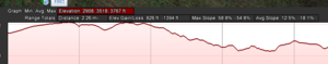
Elevation Gain/Elevation Loss Convention question from what I see you doing. Positive for gain, negative for loss? Does the order make a difference? What happens if Loss is first, then Gain? --Vhasler (talk) 18:46, 29 September 2015 (MDT)
- Straight from Google Earth elevation profile for the KML. The amount of climbing up or climbing down one-way on a trail. A perfectly flat descending hike would have 0' gain, but could have 2,000' loss in 0.5 miles, making it a hard hike back that I think would have been lost with just reporting gain before. Ultimately more data to help understand hike difficulty (short of looking at an elevation profile). --Tim (talk) 19:01, 29 September 2015 (MDT)
- Also, if you're updating trail pages, please update the IB data section. I've been just copying the new layout from the template page, copying over data as needed from the old to the new, deleting the obsoleted parts, then deleting the old template call. I learned how to have instructional text on template pages instead of seeing an error filled template. It includes descriptions of what each of the variables are for, possibly answering your initial question. --Tim (talk) 18:51, 30 September 2015 (EDT)

Upload KML?
How do I upload KML to reference in the pages? I've got a bunch I plan to add. Thanks!
--Tndude (talk) 09:28, 28 October 2015 (EDT)
- We upload them, then use the map plugin to reference them. I had a problem figuring out how to upload them within the wiki yet still have the maps plugin be able to see them. That was several versions ago of Mediawiki and a different mapping plugin so it might not be a problem anymore. I'll do some checking. In the meantime you can either email them to me and I can get them online, or contact me and I can get you FTP access to our KML folder. If it is a bunch, it's probably best to do the latter as I do find Mediawiki uploading to be a bit tedious for pictures.
- I have it on my list to do but here's some quick tips on KML's and mapping. Or just upload them as is and someone can tweak these details later. We have been putting waypoints in the wiki markup (easier for editing) and leaving the KML for just the route. Actually it's a "path" in Google Earth, the one without time/speed data (I believe those are routes or tracks). Paths can be tweaked when viewing properties allowing you to remove/add/delete the points making the path. The name of the path is the trail name. This allows clicking the path on the site and seeing its name. It's useful when we're showing multiple KML's. Pick a color of your liking, and I've been using 3.0 width and 100% opacity but I'm open to differing opinions on this. The KML file name is then the trail name as well, but at least the old mapping extension didn't like spaces, so they were all replaced with '_' (underscore, not meek faces). All of the trail stats of length, max elevation, and elevation gain/loss all come straight from the elevation profile view. Thanks! --Tim (talk) 22:31, 28 October 2015 (EDT)