Fred Behrend: Difference between revisions
(Wrong river! and fix directions) |
(convert to new trail form template) |
||
| Line 1: | Line 1: | ||
{{Trail | |||
|Banner Image= | |||
|Park=Roan Mountain State Park | |||
|Trail Marking=Green | |||
|Trail Use=Hiking | |||
|Trail Features=Vistas, Mountains | |||
|Difficulty Rating=Medium | |||
|Hike Time=1.5 hrs | |||
|Trail Distance=2.193 mi | |||
|Round Trip Distance=4.4 mi | |||
|Trail Type=In-and-Out | |||
|High Point=3,773 ft | |||
|Low Point=2,841 ft | |||
|Elevation Gain=319 ft | |||
|Elevation Loss=1,162 ft | |||
|Elevation Change Direction=West-to-East | |||
|Parking location=36.159208,-82.099615 | |||
|Trailhead location=36.159270,-82.100338 | |||
}} | |||
{{Trail Map|Other Trails=Riverside}} | |||
__TOC__ | |||
== Trail Overview == | == Trail Overview == | ||
This is part of the [[Roan Mountain State Park]] trail system. If you're staying at the campground, this is a good way to spend an hour or two as it begins and ends at the campground check-in station. It hikes through the woods past large boulders then returns along the Doe River. | This is part of the [[Roan Mountain State Park]] trail system. If you're staying at the campground, this is a good way to spend an hour or two as it begins and ends at the campground check-in station. It hikes through the woods past large boulders then returns along the Doe River. | ||
== How to get there == | == How to get there == | ||
| Line 52: | Line 33: | ||
== Route Description== | == Route Description== | ||
[[File:Fred behrend profile.png|thumb|right]] | |||
A loop trail around the campgrounds. | A loop trail around the campgrounds. | ||
| Line 140: | Line 121: | ||
<!-- Other things to check out while you're in the area. Restaurants, attractions, monuments, etc... --> | <!-- Other things to check out while you're in the area. Restaurants, attractions, monuments, etc... --> | ||
After a hike, check out Bob's Dairyland back down in Roan Mountain. | After a hike, check out Bob's Dairyland back down in Roan Mountain. | ||
== Photos == | == Photos == | ||
{{Park trail gallery|Trail={{PAGENAME}}}} | |||
Revision as of 22:27, 22 December 2019
| Fred Behrend (log in to submit report) | |
|---|---|
| Park | Roan Mountain State Park |
| Located | Roan Mountain, TennesseeLocation inherited from associated park |
| Trail Marking | Green |
| Trail UseThings allowed to do on or near the trail |
|
| FeaturesThings to see on or near the trail |
|
| Difficulty Rating | Medium |
| Hiking TimeTime from car and back. Includes any time hiking to access this trail. | 1.5 hrs0.0938 Days <br />90 Min <br /> round trip |
| Distance: | 2.193 mi3.529 km <br /> trailStrict non-repeating trail length / 4.4 mi7.081 km <br /> round tripTypical or shortest length from the car, hike the trail, and return to car |
| Trail Type | In-and-Out |
| Low / High Point | 2,841 ft947 Yards <br />865.937 Meters <br /> / 3,773 ft1,257.667 Yards <br />1,150.01 Meters <br /> |
| Elev. Gain/LossSee link for details of calculation. Gain/Loss is direction dependent. | 319 ft97.231 Meters <br /> / (1,162 ft354.178 Meters <br />) – West-to-East |
| Trip ReportsFrom user "hiked it" submissions<br />Recent is within last 90 days | No hikes logged yet |
| NearbyWithin 5 mi<br />Click link to view list | 12 trails / 48.5 mi of trail |
| Parking | 36° 9' 33.15" N, 82° 5' 58.61" W Map |
| Trailhead | 36° 9' 33.37" N, 82° 6' 1.22" W Map |
|
| |
| Show In Google Maps | |
Download KML / Upload new version / KML File Page / Create Profile Chart / gpsvisualizer Map
Trail Overview
This is part of the Roan Mountain State Park trail system. If you're staying at the campground, this is a good way to spend an hour or two as it begins and ends at the campground check-in station. It hikes through the woods past large boulders then returns along the Doe River.
How to get there
From the visitor's center:
- Continue south on TN143
- Past the pool and tennis courts, turn right into the campground area
- Park at the shelter on your left before the campground station
- Hike begins on the left just past the bridge on the campground road
Route Description

A loop trail around the campgrounds.
Accessible from this trail is Riverside Trail.
Following a clockwise hike
| Miles Out | Fred Behrend | Miles Back | Elevation (ft) |
|---|---|---|---|
| 0.0 | Trail head at bridge near campground station | 2.26 | 2,914 |
| 0.15 | Some unmarked trail shortcuts | 2.11 | 2,976 |
| 0.82 | Cross trail road marked to campground | 1.44 | 3,062 |
| 0.87 | Stream bridge crossing | 1.39 | 3,032 |
| 0.90 | Pass campground access connection | 1.36 | 3,034 |
| 1.20 | Pass large rock | 1.06 | 3,125 |
| 1.42 | Trail high point | 0.84 | 3,264 |
| 1.52 | Pass large rock | 0.74 | 3,139 |
| 1.87 | Connect with Lakeside Trail | 0.39 | 2,945 |
| 2.14 | Stream bridge | 0.12 | 2,923 |
| 2.22 | Hike through old playground | 0.04 | 2,920 |
| 2.26 | Returned to start | 0.00 | 2,914 |
Typical Conditions
Being a TN state park, the dirt and gravel trails are kept in good condition. Some of the trail sections are steep, thus can be slippery after a rain.
Fees, Permits, etc.
Misc. Information
Formally known was the Bearwallow Trail until renamed in honor of naturalist Fred Behrend
After the Hike
After a hike, check out Bob's Dairyland back down in Roan Mountain.
Photos
-

Trail Profile
-
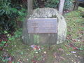
Memorial
-
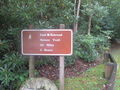
Trail head sign
-
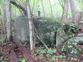
Large rock
-
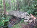
Typical stream bridge


