Fred Behrend: Difference between revisions
m (add needs) |
(Wrong river! and fix directions) |
||
| Line 35: | Line 35: | ||
| Trail pins = | | Trail pins = | ||
| Other = | | Other = | ||
| Comment = | | Comment = Loos good, except possibly some light work on descriptive content | ||
| Date reviewed = 10/24/2015 | | Date reviewed = 10/24/2015 | ||
}}<!-- | }}<!-- | ||
| Line 42: | Line 42: | ||
== Trail Overview == | == Trail Overview == | ||
<!-- Enter a overview of the trail. What attracts you to this trail, points of interest, types of flowers, lakes, and peaks that you see along the way. --> | <!-- Enter a overview of the trail. What attracts you to this trail, points of interest, types of flowers, lakes, and peaks that you see along the way. --> | ||
This is part of the [[Roan Mountain State Park]] trail system. If you're staying at the campground, this is a good way to spend an hour or two as it begins and ends at the campground check-in station. It hikes through the woods past large boulders then returns along | This is part of the [[Roan Mountain State Park]] trail system. If you're staying at the campground, this is a good way to spend an hour or two as it begins and ends at the campground check-in station. It hikes through the woods past large boulders then returns along the Doe River. | ||
== How to get there == | == How to get there == | ||
<!-- Please enter detailed instruction on how to find the trail head. --> | <!-- Please enter detailed instruction on how to find the trail head. --> | ||
From | From the [[Roan Mountain State Park|visitor's center]]: | ||
# | #Continue south on TN143 | ||
# | #Past the pool and tennis courts, turn right into the campground area | ||
# | #Park at the shelter on your left before the campground station | ||
# | #Hike begins on the left just past the bridge on the campground road | ||
== Route Description== | == Route Description== | ||
Revision as of 12:06, 24 October 2015
| |||||||||||||||||||||||||||||||||||||||||||||

Trail Overview
This is part of the Roan Mountain State Park trail system. If you're staying at the campground, this is a good way to spend an hour or two as it begins and ends at the campground check-in station. It hikes through the woods past large boulders then returns along the Doe River.
How to get there
From the visitor's center:
- Continue south on TN143
- Past the pool and tennis courts, turn right into the campground area
- Park at the shelter on your left before the campground station
- Hike begins on the left just past the bridge on the campground road
Route Description
A loop trail around the campgrounds.
Accessible from this trail is Riverside Trail.
Following a clockwise hike
| Miles Out | Fred Behrend | Miles Back | Elevation (ft) |
|---|---|---|---|
| 0.0 | Trail head at bridge near campground station | 2.26 | 2,914 |
| 0.15 | Some unmarked trail shortcuts | 2.11 | 2,976 |
| 0.82 | Cross trail road marked to campground | 1.44 | 3,062 |
| 0.87 | Stream bridge crossing | 1.39 | 3,032 |
| 0.90 | Pass campground access connection | 1.36 | 3,034 |
| 1.20 | Pass large rock | 1.06 | 3,125 |
| 1.42 | Trail high point | 0.84 | 3,264 |
| 1.52 | Pass large rock | 0.74 | 3,139 |
| 1.87 | Connect with Lakeside Trail | 0.39 | 2,945 |
| 2.14 | Stream bridge | 0.12 | 2,923 |
| 2.22 | Hike through old playground | 0.04 | 2,920 |
| 2.26 | Returned to start | 0.00 | 2,914 |
Typical Conditions
Being a TN state park, the dirt and gravel trails are kept in good condition. Some of the trail sections are steep, thus can be slippery after a rain.
Fees, Permits, etc.
Misc. Information
Formally known was the Bearwallow Trail until renamed in honor of naturalist Fred Behrend
After the Hike
After a hike, check out Bob's Dairyland back down in Roan Mountain.
Maps
Fred Behrend Trail is shown below in its blaze color of green.
Photos
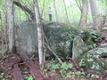
Large rock along the trail
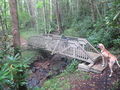
Typical stream bridge
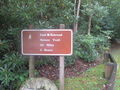
Trail head sign


