Back Hollow Road: Difference between revisions
(update map and IB) |
(Cleaning up) |
||
| Line 2: | Line 2: | ||
{{Infobox Trail | {{Infobox Trail | ||
| Image Name = BMP_cabin.JPG | | Image Name = BMP_cabin.JPG | ||
| Trail Number = | |||
| Park = Bays Mountain Park | | Park = Bays Mountain Park | ||
| City = Kingsport | | City = Kingsport | ||
| Line 23: | Line 24: | ||
== Trail Overview == | == Trail Overview == | ||
<!-- Enter a overview of the trail. What attracts you to this trail, points of interest, types of flowers, lakes, and peaks that you see along the way. --> | <!-- Enter a overview of the trail. What attracts you to this trail, points of interest, types of flowers, lakes, and peaks that you see along the way. --> | ||
Located in [[Bays Mountain Park]]. Back Hollow Road leads to less used part of | Located in [[Bays Mountain Park]]. Back Hollow Road leads to less used part of the park from Feagins Gap past old cabins and a primitive camping area. The far western part becomes difficult to travel due to blowdowns and a creek that runs in the path. | ||
== How to get there == | == How to get there == | ||
| Line 32: | Line 33: | ||
<!-- Detailed description of the route. Is there any side trails that are worth traveling? --> | <!-- Detailed description of the route. Is there any side trails that are worth traveling? --> | ||
Mostly straight shot down hollow. No blazes. | Mostly straight shot down hollow. No blazes. | ||
This trail has connections to [[Trail connects to::Lake Road (Bays Mountain Park)]], [[Trail connects to::River Mountain Road]], [[Trail connects to::Cross Ridges Trail]], [[Trail connects to::Pretty Ridge Trail]], and [[Trail connects to::Front Hollow Road]] | |||
{| class="wikitable" border="1" | {| class="wikitable" border="1" | ||
| Line 52: | Line 55: | ||
|- | |- | ||
|0.90 | |0.90 | ||
|Junction with [[ | |Junction with [[Pretty Ridge Trail|Pretty Ridge Trail]] and [[Cross Ridges Trail|Cross Ridges Trail]] | ||
|1675 | |1675 | ||
|- | |- | ||
| Line 68: | Line 71: | ||
|- | |- | ||
|1.95 | |1.95 | ||
|Connection with [[ | |Connection with [[Front Hollow Road|Front Hollow Road]] in meadow | ||
|1615 | |1615 | ||
|} | |} | ||
| Line 103: | Line 106: | ||
<!-- Finally add the trail to any Categories it should belong to. --> | <!-- Finally add the trail to any Categories it should belong to. --> | ||
[[Category:Tennessee]] [[Category:Kingsport]] [[Category:Bays Mountain Park]] [[Category:Hard]] [[Category:Hiking]] [[Category:Biking]] [[Category:Dog Friendly]] | [[Category:Tennessee]] [[Category:Kingsport]] [[Category:Bays Mountain Park]] [[Category:Hard]] [[Category:Hiking]] [[Category:Biking]] [[Category:Dog Friendly]] | ||
{{#set: | |||
|Trail page needs=Detail route description;Trail pins;Update mileage;Update 1|+sep=; | |||
}} | |||
Revision as of 09:19, 4 October 2015
| |||||||||||||||||||||||||||||||||||||||||||||

Trail Overview
Located in Bays Mountain Park. Back Hollow Road leads to less used part of the park from Feagins Gap past old cabins and a primitive camping area. The far western part becomes difficult to travel due to blowdowns and a creek that runs in the path.
How to get there
Most will start at Feagins Gap, thus approach from Lake Road.
Route Description
Mostly straight shot down hollow. No blazes.
This trail has connections to Lake Road (Bays Mountain Park), River Mountain Road, Cross Ridges Trail, Pretty Ridge Trail, and Front Hollow Road
| Miles | Back Hollow Road | Elevation (ft) |
|---|---|---|
| 0.00 | Feagins Gap | 1910 |
| 0.56 | Cabin maintained by park | 1720 |
| 0.62 | Primative campsite | 1700 |
| 0.90 | Junction with Pretty Ridge Trail and Cross Ridges Trail | 1675 |
| 1.72 | Barbed wire fence gate | 1640 |
| 1.80 | Junction with Pretty Ridge Trail across field and behind barn. Look for sty over fence. | 1615 |
| 1.86 | Large gate - trail veers left | 1635 |
| 1.95 | Connection with Front Hollow Road in meadow | 1615 |
Mountain biking is only to the primitive campsite, then hiking only.
Typical Conditions
Former gravel road to primitive campsite. Then a dirt road to far west end. While there is a line on the map, that does not mean there is a trail on the ground. Past split to Pretty Ridge Trail has been abandoned by the park, thus no maintenance being done.
Misc. Information
Maps
Photos
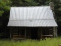
Cabin near primative campsite