|
|
| Line 1: |
Line 1: |
| <!-- The following few lines create the "Infobox" table template. Please scroll down to edit the main content of the article. -->{{Infobox Trail
| | {{Trail |
| | Image Name =
| | |Banner Image= |
| | Trail Number = FS# 4551
| | |Park=Beartree Recreation Area |
| | Park =
| | |Trail Marking=Purple or Yellow Diamond |
| | City = Kingsport
| | |Trail Use=Hiking |
| | State = Tennessee
| | |Trail Features=Mountains |
| | Marking = None
| | |Difficulty Rating=Medium |
| | Trail Use = {{Hike}} {{Biking}} {{Dogs}}
| | |Hike Time=2 hrs |
| | Difficulty Rating = Medium
| | |Trail Distance=2.193 mi |
| | Hike Time = 2 Hours
| | |Round Trip Distance=4.4 mi |
| | Round Trip Distance = 6.46 Mi
| | |Trail Type=In-and-Out |
| | Trail Distance = 3.23 Mi
| | |High Point=3,773 ft |
| | Trail Type = In-and-Out
| | |Low Point=2,841 ft |
| | Elevation Gain = 843 Ft
| | |Elevation Gain=319 ft |
| | Elevation Loss = --1,452 Ft
| | |Elevation Loss=1,162 ft |
| | High Point = 3,695 Ft
| | |Elevation Change Direction=West-to-East |
| | Parking coords = 36.655325,-81.690211
| | |Parking location=36.655325,-81.690211 |
| | Trailhead coords = 36.677592,-81.681880
| | |Trailhead location=36.677592,-81.681880 |
| | Medical = Indian Path Hospital
| | }} |
| }}<!-- End Infobox template table--> | | {{Trail Map}} |
| {{Trail page needs | | |
| | Hide needs =
| | __TOC__ |
| | KML =
| | |
| | Updated KML =
| |
| | Detail route description =
| |
| | Photos = True
| |
| | Winter photos = True
| |
| | Remove prefix =
| |
| | Update infobox =
| |
| | Infobox data update =
| |
| | Trail pins = True
| |
| | Other = Assign park
| |
| | Comment = What park is this associated with?
| |
| | Date reviewed = 10/16/2015
| |
| }}<!-- Start of Main Page -->
| |
| == Trail Overview == | | == Trail Overview == |
| <!-- Enter overview of the trail. What attracts you to this trail, points of interest, types of flowers, lakes, and peaks that you see along the way. -->
| |
| Connector trail between AT and [[Iron Mountain Trail - North]]. | | Connector trail between AT and [[Iron Mountain Trail - North]]. |
|
| |
|
| Line 48: |
Line 35: |
|
| |
|
| == Route Description== | | == Route Description== |
| <!-- Detailed description of the route. Is there any side trails that are worth traveling? -->
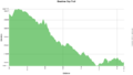
| | [[File:Beartree gap trail profile.png|thumb|right]] |
| Beartree Gap Trail is Forest Service Trail # 4551. Two different blazes reported as purple (rectangles?) – or yellow diamonds. | | Beartree Gap Trail is Forest Service Trail # 4551. Two different blazes reported as purple (rectangles?) – or yellow diamonds. |
|
| |
|
| Line 102: |
Line 89: |
|
| |
|
| Another proposed 11.2 mile loop hike involving this trail would be to start at Fisherman's parking lot, take this Beartree Gap Trail across US58 to the AT (~0.5 mi), southbound towards Saunders Shelter to [[Virginia Creeper Trail]] (4.1 mi), left/westbound on VCT through Taylors Valley to rejoin the AT (4.2 mi), southbound to Beartree Gap Trail (1.2), and back to the parking lot. Suggested that it could be done in six hours. | | Another proposed 11.2 mile loop hike involving this trail would be to start at Fisherman's parking lot, take this Beartree Gap Trail across US58 to the AT (~0.5 mi), southbound towards Saunders Shelter to [[Virginia Creeper Trail]] (4.1 mi), left/westbound on VCT through Taylors Valley to rejoin the AT (4.2 mi), southbound to Beartree Gap Trail (1.2), and back to the parking lot. Suggested that it could be done in six hours. |
|
| |
| == Typical Conditions ==
| |
| <!-- Typical conditions throughout the year of what to expect on the trail. Rocky, muddy, sandy, flowers, lots of downed trees? -->
| |
|
| |
|
| ==Fees, Permits, etc. == | | ==Fees, Permits, etc. == |
| <!-- Please list any Fees, Permits, Regulations, etc. that may be required on this trail.--> | | <!-- Please list any Fees, Permits, Regulations, etc. that may be required on this trail.--> |
| Park for free at front lot (outside gate). Main gate is open 7 AM-10 PM during April 15 through October 31 with $5 day use fee per vehicle. | | Park for free at front lot (outside gate). Main gate is open 7 AM-10 PM during April 15 through October 31 with $5 day use fee per vehicle. |
|
| |
| == After the Hike ==
| |
| <!-- Anywhere interesting to stop by since you're in the area!! -->
| |
|
| |
|
| == Misc. Information == | | == Misc. Information == |
| <!-- Enter any additional information that doesn't fit an any other fields. Does this trail require any permits for overnight? parking? --> | | <!-- Enter any additional information that doesn't fit an any other fields. Does this trail require any permits for overnight? parking? --> |
| [http://www.fs.usda.gov/recarea/gwj/recreation/hiking/recarea/?recid=73579&actid=50 Beartree Recreation Area website] | | [http://www.fs.usda.gov/recarea/gwj/recreation/hiking/recarea/?recid=73579&actid=50 Beartree Recreation Area website] |
|
| |
| == Maps ==
| |
| <!-- You can place pictures, PDF's, links, or even create a Google map with your waypoints and place it here. -->
| |
| Beartree Gap Trail is shown as red line below, while the Appalachian Trail is in yellow.
| |
|
| |
| <display_map type="terrain" height="500" width="auto" gkml="http://tehcc.org/clubwiki/kml/Beartree_Gap_Trail.kml,
| |
| http://tehcc.org/clubwiki/kml/AT-MRATC.kml">
| |
|
| |
| 36.655325, -81.690211~Parking area for Beartree Gap Trail~ ~MarkerA.png
| |
| 36.677971, -81.681869~Shaw's Gap~ ~MarkerG.png
| |
| 36.664319, -81.691153~Junction with Yancy Trail~ ~MarkerG.png
| |
| 36.654610, -81.693317~Wooden footbridge~ ~MarkerL.png
| |
| 36.651197, -81.689068~Junction with AT~ ~MarkerG.png
| |
| </display_map>
| |
|
| |
|
| == Photos == | | == Photos == |
| <gallery>
| | {{Park trail gallery|Trail={{PAGENAME}}}} |
| <!-- Place any pictures from this trail below. Add a picture by typing Image:imagename.extension -->
| | {{Map Marker|Icon Type=Parking|Marker Title=Parking area for Beartree Gap Trail|Marker Description= |Marker Location=36.655325, -81.690211}} |
| Image:placeholder.jpg
| | {{Map Marker|Icon Type=Point of interest|Marker Title=Shaw's Gap|Marker Description= |Marker Location=36.677971, -81.681869}} |
| <!-- Do not remove the end gallery code.-->
| | {{Map Marker|Icon Type=Point of interest|Marker Title=Junction with Yancy Trail|Marker Description= |Marker Location=36.664319, -81.691153}} |
| </gallery>
| | {{Map Marker|Icon Type=Trail bridge|Marker Title=Wooden footbridge|Marker Description= |Marker Location=36.654610, -81.693317}} |
| | | {{Map Marker|Icon Type=Point of interest|Marker Title=Junction with AT|Marker Description= |Marker Location=36.651197, -81.689068}} |
| <!-- Finally add the trail to any Categories it should belong to. Please keep the State category. To make a new category just type [[Category:mycategory]]. Keep in mind categories are case sensitive. -->
| |
| [[Category:Virginia]] [[Category:Biking]] [[Category:Medium]] [[Category:Dog Friendly]]
| |
| Beartree Gap Trail
(log in to submit report)
|
|
|
|
|
| Park
|
Beartree Recreation Area
|
| Located
|
Damascus, VirginiaLocation inherited from associated park
|
| Trail Marking
|
Purple or Yellow Diamond
|
| Trail UseThings allowed to do on or near the trail
|

|
| FeaturesThings to see on or near the trail
|

|
| Difficulty Rating
|
Medium
|
| Hiking TimeTime from car and back. Includes any time hiking to access this trail.
|
2 hrs0.125 Days <br />120 Min <br /> round trip
|
| Distance:
|
2.193 mi3.529 km <br /> trailStrict non-repeating trail length / 4.4 mi7.081 km <br /> round tripTypical or shortest length from the car, hike the trail, and return to car
|
| Trail Type
|
In-and-Out
|
| Low / High Point
|
2,841 ft947 Yards <br />865.937 Meters <br /> / 3,773 ft1,257.667 Yards <br />1,150.01 Meters <br />
|
| Elev. Gain/LossSee link for details of calculation. Gain/Loss is direction dependent.
|
319 ft97.231 Meters <br /> / (1,162 ft354.178 Meters <br />) – West-to-East
|
| Trip ReportsFrom user "hiked it" submissions<br />Recent is within last 90 days
|
No hikes logged yet
|
| NearbyWithin 5 mi<br />Click link to view list
|
No other Trails within 5 mi
|
| Parking
|
36° 39' 19.17" N, 81° 41' 24.76" W Map
|
| Trailhead
|
36° 40' 39.33" N, 81° 40' 54.77" W Map
|
Loading map... {"type":"ROADMAP","minzoom":false,"maxzoom":false,"types":["ROADMAP","SATELLITE","HYBRID","TERRAIN"],"mappingservice":"googlemaps3","width":"100%","height":"180px","centre":false,"title":"","label":"","icon":"","lines":[],"polygons":[],"circles":[],"rectangles":[],"copycoords":false,"static":false,"visitedicon":"","wmsoverlay":false,"zoom":8,"layers":[],"controls":[""],"zoomstyle":"DEFAULT","typestyle":"DEFAULT","autoinfowindows":false,"resizable":false,"kmlrezoom":false,"poi":true,"cluster":false,"clustergridsize":60,"clustermaxzoom":20,"clusterzoomonclick":true,"clusteraveragecenter":true,"clusterminsize":2,"imageoverlays":[],"kml":[],"gkml":[],"searchmarkers":"","fullscreen":false,"scrollwheelzoom":false,"locations":[{"text":"\u003Cb\u003E\u003Cdiv class=\"mw-parser-output\"\u003E\u003Cp\u003EBeartree Gap Trail\n\u003C/p\u003E\u003C/div\u003E\u003C/b\u003E\u003Cdiv class=\"mw-parser-output\"\u003E\u003Cp\u003EMain Parking Location\n\u003C/p\u003E\u003C/div\u003E","title":"Beartree Gap Trail\n","link":"","lat":36.65532499999999771489456179551780223846435546875,"lon":-81.690211000000005014953785575926303863525390625,"icon":""}]} |
| Show In Google Maps
|
Loading map...
{"format":"googlemaps3","type":"TERRAIN","minzoom":false,"maxzoom":false,"types":["SATELLITE","HYBRID","TERRAIN"],"limit":50,"offset":0,"link":"none","sort":[""],"order":[],"headers":"show","mainlabel":"","intro":"","outro":"","searchlabel":"... further results","default":"","import-annotation":false,"width":"auto","height":"600px","centre":false,"title":"","label":"","icon":"","lines":[],"polygons":[],"circles":[],"rectangles":[],"copycoords":false,"static":false,"visitedicon":"","wmsoverlay":false,"zoom":false,"layers":[],"controls":["pan","zoom","type","scale","streetview","rotate"],"zoomstyle":"DEFAULT","typestyle":"DEFAULT","autoinfowindows":false,"resizable":false,"kmlrezoom":true,"poi":true,"cluster":false,"clustergridsize":60,"clustermaxzoom":20,"clusterzoomonclick":true,"clusteraveragecenter":true,"clusterminsize":2,"imageoverlays":[],"kml":[],"gkml":["https://tehcc.org/clubwiki/images/Beartree_Gap_Trail.kml"],"searchmarkers":"","fullscreen":false,"scrollwheelzoom":false,"showtitle":false,"hidenamespace":true,"template":"Map Balloon Template","userparam":"","activeicon":"","pagelabel":false,"ajaxcoordproperty":"","ajaxquery":"","locations":[{"text":"\u003Cp\u003E\u003Cb\u003E\u003Ca class=\"mw-selflink selflink\"\u003EBeartree Gap Trail\u003C/a\u003E\u003C/b\u003E\u003Cbr /\u003E\u003C/p\u003E\u003Chr /\u003E\u003Cp\u003E3.19\u0026#160;Mi (5.13\u0026#160;km)\u003Cbr /\u003EDifficulty: Medium\u003Cbr /\u003EMarking: Purple or Yellow Diamond\u003C/p\u003E","title":"Beartree Gap Trail","link":"","lat":36.67759000000000213503881241194903850555419921875,"lon":-81.681880000000006702975952066481113433837890625,"icon":"/clubwiki/images/MarkerT.png"},{"text":"\u003Cp\u003E\u003Cb\u003EJunction with Yancy Trail\u003C/b\u003E\u003Cbr /\u003E\u003C/p\u003E\u003Chr /\u003E\u003Cp\u003EJunction with Yancy Trail\u003C/p\u003E","title":"Beartree Gap Trail","link":"","lat":36.66431899999999899364411248825490474700927734375,"lon":-81.6911529999999999063220457173883914947509765625,"icon":"/clubwiki/images/MarkerG.png"},{"text":"\u003Cp\u003E\u003Cb\u003EJunction with AT\u003C/b\u003E\u003Cbr /\u003E\u003C/p\u003E\u003Chr /\u003E\u003Cp\u003EJunction with AT\u003C/p\u003E","title":"Beartree Gap Trail","link":"","lat":36.65119700000000335649019689299166202545166015625,"lon":-81.6890680000000060090314946137368679046630859375,"icon":"/clubwiki/images/MarkerG.png"},{"text":"\u003Cp\u003E\u003Cb\u003EParking area for Beartree Gap Trail\u003C/b\u003E\u003Cbr /\u003E\u003C/p\u003E\u003Chr /\u003E\u003Cp\u003EParking area for Beartree Gap Trail\u003C/p\u003E","title":"Beartree Gap Trail","link":"","lat":36.65532499999999771489456179551780223846435546875,"lon":-81.690211000000005014953785575926303863525390625,"icon":"/clubwiki/images/MarkerA.png"},{"text":"\u003Cp\u003E\u003Cb\u003EShaw's Gap\u003C/b\u003E\u003Cbr /\u003E\u003C/p\u003E\u003Chr /\u003E\u003Cp\u003EShaw's Gap\u003C/p\u003E","title":"Beartree Gap Trail","link":"","lat":36.6779709999999994352037901990115642547607421875,"lon":-81.6818690000000060535967350006103515625,"icon":"/clubwiki/images/MarkerG.png"},{"text":"\u003Cp\u003E\u003Cb\u003EWooden footbridge\u003C/b\u003E\u003Cbr /\u003E\u003C/p\u003E\u003Chr /\u003E\u003Cp\u003EWooden footbridge\u003C/p\u003E","title":"Beartree Gap Trail","link":"","lat":36.65460999999999813780959811992943286895751953125,"lon":-81.6933169999999932997525320388376712799072265625,"icon":"/clubwiki/images/MarkerL.png"}]}
Download KML / Upload new version / KML File Page / Create Profile Chart / gpsvisualizer Map
Trail Overview
Connector trail between AT and Iron Mountain Trail - North.
How to get there
From Kingsport, TN
- North on I-81 into Virginia.
- Take Exit 19 (Abingdon) and turn right/east onto US-58.
- Go 12 miles to Damascus.
- Continue through town on US-58 and travel another 7 miles to the campground entrance on the left.
- Free parking on right in the fisherman’s lot.
Route Description
Beartree Gap Trail is Forest Service Trail # 4551. Two different blazes reported as purple (rectangles?) – or yellow diamonds.
| Distance from IMT (mi)
|
Distance from AT (mi)
|
Elevation (ft)
|
Feature
|
| 0.0
|
3.2
|
3570
|
Iron Mountain Trail - North at Shaw's Gap
|
| 0.1
|
3.1
|
3560
|
Shaw Gap Trail - 1.01 mile to Beartree Rec. camping area
|
| 1.6
|
1.6
|
3225
|
Intersect Yancy Trail – 0.26 mile spur to Beartree Gap Road
|
| 2.4
|
0.8
|
2970
|
Cross Beartree Campground Road/FS Road 837
|
| 2.6
|
0.6
|
3040
|
Fisherman’s parking lot
|
| 2.8
|
0.4
|
3000
|
Cross dam for Beartree Dam
|
| 3.0
|
0.2
|
3050
|
Cross Highway US-58
|
| 0.0
|
3.2
|
3025
|
Appalachian Trail
|
The Mt. Rogers AT Club suggests that Beartree Gap Trail could part of a 25 mile loop hike on the Appalachian Trail, Iron Mountain Trail, and Feathercamp Ridge Trail.
Another proposed 11.2 mile loop hike involving this trail would be to start at Fisherman's parking lot, take this Beartree Gap Trail across US58 to the AT (~0.5 mi), southbound towards Saunders Shelter to Virginia Creeper Trail (4.1 mi), left/westbound on VCT through Taylors Valley to rejoin the AT (4.2 mi), southbound to Beartree Gap Trail (1.2), and back to the parking lot. Suggested that it could be done in six hours.
Fees, Permits, etc.
Park for free at front lot (outside gate). Main gate is open 7 AM-10 PM during April 15 through October 31 with $5 day use fee per vehicle.
Misc. Information
Beartree Recreation Area website
Photos
