Spivey Gap to Big Bald
| Spivey Gap to Big Bald (log in to submit report) | |
|---|---|

| |
| Trail System | Appalachian Trail |
| Located | Erwin, Tennessee |
| Trail Marking | White Blaze |
| Trail UseThings allowed to do on or near the trail |
|
| FeaturesThings to see on or near the trail |
|
| Difficulty Rating | Hard |
| Hiking TimeTime from car and back. Includes any time hiking to access this trail. | 88 Hours <br />0.5 Days <br />480 Min <br /> round trip |
| Distance: | 7.5 mi12.07 km <br /> trailStrict non-repeating trail length / 15 mi24.14 km <br /> round tripTypical or shortest length from the car, hike the trail, and return to car |
| Trail Type | In-and-Out |
| Low / High Point | 32613,261 Feet <br />1,087 Yards <br />993.953 Meters <br /> / 55385,538 Feet <br />1,846 Yards <br />1,687.982 Meters <br /> |
| Elev. Gain/LossSee link for details of calculation. Gain/Loss is direction dependent. | 30023,002 Feet <br />915.01 Meters <br /> / (-725-725 Feet <br />-220.98 Meters <br />) – North-to-South |
| Trip ReportsFrom user "hiked it" submissions<br />Recent is within last 90 days | 1 logged hikes (0 recent) |
| NearbyWithin 5 mi<br />Click link to view list | 1 trails / 11.2 mi of trail |
| Parking | 36° 1' 54.30" N, 82° 25' 12.43" W Map |
| Trailhead | 36° 1' 54.30" N, 82° 25' 12.43" W Map |
|
| |
| Show In Google Maps | |
Trail Overview[edit]
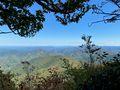
This section of the Appalachian Trail is the section just south of the sections that are maintained by TEHCC. It is maintained by the Carolina Mountain Club. This is a long climb up the hill to a great lookout. There are some good camping locations within the first mile. There are two good lookouts on the way up to the top, but the 360 degree views from the end of the hike are the best of the hike. There is also a bird sanctuary/tracking area near the top, with good signage to alert hikers; be carful to not get off the trail or make too much noise when hiking through this section. There is a shelter with water about 5 miles away from the parking area.
How To Get There[edit]
Take exit 43 on Interstate 26. Turn right to go South on highway 19W. Continue on highway 19W for 1.1 mi and then turn left onto Spivey Mountain Rd and also to stay on 19W South. If you cross back under Interstate 26 then you have missed the turn onto Spivey Mountain Rd. Once on Spivey Mountain Rd you will continue another 7.7 miles and the parking area will be on the right. You will cross into North Carolina on your way to the parking area.
Route Description[edit]
Typical Conditions[edit]
This is part of the AT, so it is traditionally in great shape.
After the Hike[edit]
Spivey Gap is a fairly remote location, so plan on getting back in the car and driving a few minutes to get to any gas stations or other locations.
Miscellaneous Information[edit]
Link to Spivey Gap to Nolichucky River Hike which is the section hiking to the north from Spivey Gap.
Gallery[edit]

Big Bald Lookout 1
Big Bald Lookout 2
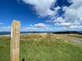
Big Bald Summit

