Daniel Boone Trail
| Daniel Boone Trail (log in to submit report) | |
|---|---|

| |
| Highlight | The last portion of the Wilderness Trail not paved |
| Trail System | Daniel Boone Wilderness Trail |
| Located | Duffield, Virginia |
| Trail Marking | None |
| Trail UseThings allowed to do on or near the trail |
|
| FeaturesThings to see on or near the trail |
|
| Difficulty Rating | Medium |
| Hiking TimeTime from car and back. Includes any time hiking to access this trail. | 3 hrs0.188 Days <br />180 Min <br /> round trip |
| Distance: | 2.979 mi4.794 km <br /> trailStrict non-repeating trail length / 6.0 mi9.656 km <br /> round tripTypical or shortest length from the car, hike the trail, and return to car |
| Trail Type | In-and-Out |
| Low / High Point | 1,438 ft479.333 Yards <br />438.302 Meters <br /> / 2,586 ft862 Yards <br />788.213 Meters <br /> |
| Elev. Gain/LossSee link for details of calculation. Gain/Loss is direction dependent. | 1,148 ft349.91 Meters <br /> / (0 ft0 Meters <br />) – East-to-West |
| Trip ReportsFrom user "hiked it" submissions<br />Recent is within last 90 days | 1 logged hikes (0 recent) |
| NearbyWithin 5 mi<br />Click link to view list | No other Trails within 5 mi |
| Parking | 36° 43' 7.61" N, 82° 48' 37.98" W Map |
| Trailhead | 36° 43' 7.61" N, 82° 48' 37.98" W Map |
|
| |
| Show In Google Maps | |
Download KML / Upload new version / KML File Page / Create Profile Chart / gpsvisualizer Map
Trail Overview
Follow some of the footsteps by Daniel Boone up to Kane Gap in Powell Mountain. This section is cited to be the only part of the famous Wilderness Road which has not been paved. However, while there is a sign at the trailhead and reference on Scott County Tourism website, there is no actual marked trail since the old forest roads cross both private and public property. This wiki entry has a proposed route for you to take, but likely only Kane Gap itself was on the original Wilderness Trail.
How to get there
From Kingsport, TN
- North on US-23 to Duffield.
- Turn left/west at the red-light onto US-58/421 (Duff-Patt Highway).
- Turn right/north onto either Industrial Park Rd/VA 879 or Daniel Boone Rd/VA 772. (Note: Google Maps is incorrect as Technology Trail Ln does not connect with Fraley Ave., but dead ends north of the interpretive center.)
- Turn left/west onto Fraley Ave.
- Shortly you’ll see a weathered “pink” or “orange” gate on the right. It now appears to be regularly locked. Parking is along the residential street.
The house across the way is 557 Fraley Avenue, Duffield, VA. Do not try other adjacent house numbers as Google Maps takes you to the wrong location.
Route Description

This hike is in-and-out, thus information provide one-way below.
| Miles | Feature | Elevation |
|---|---|---|
| 0.00 miles | Parking at locked gate | 1,435 feet |
| 1.50 miles | Split in forest roads - locked gate on left, take right | 1,950 feet |
| 2.20 miles | National Forest sign | 2,200 feet |
| 2.90 miles | Intersect of forest roads - EL carved on tree - continue left/straight not uphill/right | 2,480 feet |
| 3.00 miles | Kane Gap | 2,600 feet |
The forest road is also reported to continue down into Wallen’s Creek valley for an extended hike.
Typical Conditions
Very rarely used. Not a typical trail as half to three-quarters mile is a gravel road, then walking on former logging roads winding up to the mountain gap. Does not appear to be formally maintained.
Views are obscured by forests which line the path, thus late fall to early spring would be good if interested in looking down into the valleys.
During summer, lots of poison ivy and stinging nettle were encountered in places, thus long pants in cooler weather might be a better experience.
Fees, Permits, etc.
No fees or permits are required for day hiking. Open sunrise to sunset. Parking along residential street, thus consider the neighbors.
After the Hike
Or before. Stop at the Daniel Boone Wilderness Trail Interpretive Center at 371 Technology Trail Lane in Duffield for interesting facts and history. A short movie, then walk through exhibits with limited interaction. Open Friday through Monday from 10 a.m. to 6 p.m. Gate closed and locked at entrance on Technology Trail. Kane Gap can be viewed clearly from the front building entrance.
Misc. Information
There is also a different Kane Gap in West Virginia.
Reported that the Morrell mushrooms are seen along the trail during second or third week in April.
Kane Gap Trail, also stated on the Scott County Tourism website, appears to be hiking Jefferson National Forest Road 642 from near(?) Kane Gap to Tito Drive. Intersection with this Daniel Boone Trail is uncertain on making an extended hike with shuttling.
Photos
-
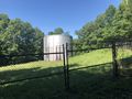
City water tower
-
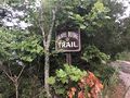
Daniel Boone Trail Banner
-
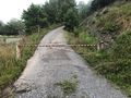
Locked gate at trailhead
-

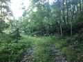
Trail Profile
-
Do Not Pass thru this gate - private property
-
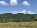
Kane Gap as viewed from interpretive center


