Bark Camp Lakeshore Trail
| Bark Camp Lakeshore Trail (log in to submit report) | |
|---|---|

| |
| Highlight | The path encircles the lake with little elevation change to give opportunity to view nature. Connects to <!--LINK'" 0:0--> |
| Trail Number | 211 |
| Park | Bark Camp Lake |
| Land Owner | Virginia Department of Forestry |
| Located | Dungannon, VirginiaLocation inherited from associated park |
| Trail Marking | Yellow metal diamond |
| Trail UseThings allowed to do on or near the trail |
|
| FeaturesThings to see on or near the trail |
|
| Difficulty Rating | Easy |
| Hiking TimeTime from car and back. Includes any time hiking to access this trail. | 2 hrs0.125 Days <br />120 Min <br /> round trip |
| Distance: | 3.70 mi5.955 km <br /> trailStrict non-repeating trail length / 3.70 mi5.955 km <br /> round tripTypical or shortest length from the car, hike the trail, and return to car |
| Trail Type | Loop |
| Low / High Point | 2720 ft906.667 Yards <br />829.056 Meters <br /> / 2830 ft943.333 Yards <br />862.584 Meters <br /> |
| Elev. Gain/LossSee link for details of calculation. Gain/Loss is direction dependent. | 320 ft97.536 Meters <br /> / (-320 ft-97.536 Meters <br />) – Clockwise |
| Trip ReportsFrom user "hiked it" submissions<br />Recent is within last 90 days | 1 logged hikes (0 recent) |
| NearbyWithin 5 mi<br />Click link to view list | 2 trails / 3.2 mi of trail |
| Parking | 36° 51' 59.98" N, 82° 31' 27.01" W Map |
| Trailhead | 36° 52' 1.09" N, 82° 31' 26.69" W Map |
|
| |
| Show In Google Maps | |
Download KML / Upload new version / KML File Page / Create Profile Chart / gpsvisualizer Map
Trail Overview[edit]
The just under four mile loop trail walks around 45 acre lake created by damming Little Stony Creek. Features views of the lake and boardwalk through wetlands.
How To Get There[edit]
Refer to the park page for directions from Kingsport. Pass the turn for the campground to parking lot for the fishing piers.
Route Description[edit]
Starting from the parking lot, you can go either direction on the loop trail. This basic description is clockwise from the fishing piers.
| Miles CW | Miles CCW | Elevation (ft) | Description |
|---|---|---|---|
| 0.0 | 3.7 | 2763 | At fishing pier |
| 0.3 | 3.4 | 2765 | Reach north end of earthen dam. Junction with Chief Benge Trail. |
| 0.4 | 3.3 | 2737 | Sharp right into the woods for the lakeside path. |
| 0.8 | 2.9 | 2735 | Cross small stream. |
| 1.7 | 2.0 | 2750 | Cross another small stream |
| 2.2 | 1.5 | 2733 | Cross Little Stony Creek |
| 2.5 | 1.2 | 2760 | Junction with Chief Benge Trail but continue near lake |
| Pass two unmarked trails up to the campground | |||
| 3.7 | 0.0 | 2763 | Back at finishing pier |
Typical Conditions[edit]
Combination of hard dirt trail in forest plus wood boardwalks. A report of having to wade across spillway.
Fees, Permits, etc.[edit]
$3 day use fee - pay at information kiosk in main parking lot.
Dogs are also able to use this trail but must be kept on leash.
After the Hike[edit]
Miscellaneous Information[edit]
Gallery[edit]
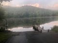
Boat Ramp
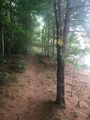
Trail marker
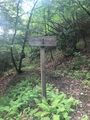
Chief Benge Scout Trail sign
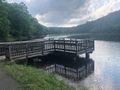
Fishing Pier


