Tower Ridge Trail: Difference between revisions
m (add needs) |
(converting to new page style - first pass) |
||
| Line 1: | Line 1: | ||
{{Trail | |||
|Park=Buffalo Mountain Park | |||
|Land Owner=Johnson City Parks & Rec | |||
|Trail Marking=Blue | |||
|Trail Use=Hiking | |||
|Trail Features=Vistas | |||
|Difficulty Rating=Medium | |||
|Hike Time=1 hr | |||
|Trail Distance=1.96 mi | |||
|Round Trip Distance=3.92 mi | |||
|Trail Type=Segment | |||
|High Point=3,177 ft | |||
|Low Point=2,269 ft | |||
|Elevation Gain=956 ft | |||
|Elevation Loss=-54 ft | |||
|Elevation Change Direction=North-to-South | |||
|Parking location=36.27865, -82.3461 | |||
|Trailhead location=36.277551,-82.341482 | |||
}} | |||
{{Trail Map|Other Trails=White Rock Trail}} | |||
}} | Tower Ridge Trail is the blue line, while [[White Rock Trail]] is in black. | ||
<br />Note: The route for Highridge Road is incorrect as the service road is closed with a gate. | |||
__TOC__ | |||
== Trail Overview == | == Trail Overview == | ||
Located in [[Buffalo Mountain Park]], this trail offers an alternative hiking route up to the communication towers area. | Located in [[Buffalo Mountain Park]], this trail offers an alternative hiking route up to the communication towers area. | ||
== How to get there == | == How to get there == | ||
Refer to the “How to get there” instructions on the [[Buffalo Mountain Park]] page. Take the gravel road left to the alternative parking area. The actual lower trailhead is reached from the [[White Rock Trail]] by either heading into Hartsell Hollow or heading up the steep gravel service road. | Refer to the “How to get there” instructions on the [[Buffalo Mountain Park]] page. Take the gravel road left to the alternative parking area. The actual lower trailhead is reached from the [[White Rock Trail]] by either heading into Hartsell Hollow or heading up the steep gravel service road. | ||
== Route Description== | == Route Description== | ||
The blue blazed Tower Ridge Trail travels between two junctions with the [[White Rock Trail]]. The lower trailhead is in the power line right-of-way, while the upper trailhead is behind the communication towers. The steep and narrow trail follows the ridgeline to the west of the service road. At the upper end, it briefly connects to and travels the service road. | The blue blazed Tower Ridge Trail travels between two junctions with the [[White Rock Trail]]. The lower trailhead is in the power line right-of-way, while the upper trailhead is behind the communication towers. The steep and narrow trail follows the ridgeline to the west of the service road. At the upper end, it briefly connects to and travels the service road. | ||
| Line 55: | Line 34: | ||
== Typical Conditions == | == Typical Conditions == | ||
The blue blazes were recently repainted, thus the route is clear once on this trail. It is a narrow and steep path winding along the ridgeline through rhododendron and small trees. Views to the north can be had when the leaves are down. Watch out for the many briars growing along the trail! | The blue blazes were recently repainted, thus the route is clear once on this trail. It is a narrow and steep path winding along the ridgeline through rhododendron and small trees. Views to the north can be had when the leaves are down. Watch out for the many briars growing along the trail! | ||
This area was not affected by the 2008 fire. | This area was not affected by the 2008 fire. | ||
== | ==Fees, Permits, etc. == | ||
<!-- | <!-- Please list any Fees, Permits, Regulations, etc. that may be required on this trail.--> | ||
No fees or permits required. | |||
== Photos == | == Photos == | ||
{{Park trail gallery|Trail={{PAGENAME}}}} | |||
{{Map Marker|Icon Type=Parking|Marker Title=Alternate parking lot|Marker Description= |Marker Location=36.278646,-82.346102}} | |||
{{Map Marker|Icon Type=Trail sign|Marker Title=Lower trailhead off [[White Rock Trail]]|Marker Description= |Marker Location=36.277581,-82.341454}} | |||
{{Map Marker|Icon Type=Road crossing|Marker Title=Junction with service road|Marker Description= |Marker Location=36.268854,-82.339339}} | |||
Revision as of 22:44, 19 September 2021
| Tower Ridge Trail (log in to submit report) | |
|---|---|
| Park | Buffalo Mountain Park |
| Land Owner | Johnson City Parks & Rec |
| Located | Johnson City, TennesseeLocation inherited from associated park |
| Trail Marking | Blue |
| Trail UseThings allowed to do on or near the trail |
|
| FeaturesThings to see on or near the trail |
|
| Difficulty Rating | Medium |
| Hiking TimeTime from car and back. Includes any time hiking to access this trail. | 1 hr0.0625 Days <br />60 Min <br /> round trip |
| Distance: | 1.96 mi3.154 km <br /> trailStrict non-repeating trail length / 3.92 mi6.309 km <br /> round tripTypical or shortest length from the car, hike the trail, and return to car |
| Trail Type | Segment |
| Low / High Point | 2,269 ft756.333 Yards <br />691.591 Meters <br /> / 3,177 ft1,059 Yards <br />968.35 Meters <br /> |
| Elev. Gain/LossSee link for details of calculation. Gain/Loss is direction dependent. | 956 ft291.389 Meters <br /> / (-54 ft-16.459 Meters <br />) – North-to-South |
| Trip ReportsFrom user "hiked it" submissions<br />Recent is within last 90 days | No hikes logged yet |
| NearbyWithin 5 mi<br />Click link to view list | 9 trails / 8.9 mi of trail |
| Parking | 36° 16' 43.14" N, 82° 20' 45.96" W Map |
| Trailhead | 36° 16' 39.18" N, 82° 20' 29.34" W Map |
|
| |
| Show In Google Maps | |
Download KML / Upload new version / KML File Page / Create Profile Chart / gpsvisualizer Map
Tower Ridge Trail is the blue line, while White Rock Trail is in black.
Note: The route for Highridge Road is incorrect as the service road is closed with a gate.
Trail Overview
Located in Buffalo Mountain Park, this trail offers an alternative hiking route up to the communication towers area.
How to get there
Refer to the “How to get there” instructions on the Buffalo Mountain Park page. Take the gravel road left to the alternative parking area. The actual lower trailhead is reached from the White Rock Trail by either heading into Hartsell Hollow or heading up the steep gravel service road.
Route Description
The blue blazed Tower Ridge Trail travels between two junctions with the White Rock Trail. The lower trailhead is in the power line right-of-way, while the upper trailhead is behind the communication towers. The steep and narrow trail follows the ridgeline to the west of the service road. At the upper end, it briefly connects to and travels the service road.
A roughly three mile loop hike can be done in couple of hours (plus stops) by hiking up the Tower Ridge Trail and returning by the White Rock Trail. The latter offers views to the east of the I-26 valley.
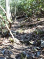
Typical Conditions
The blue blazes were recently repainted, thus the route is clear once on this trail. It is a narrow and steep path winding along the ridgeline through rhododendron and small trees. Views to the north can be had when the leaves are down. Watch out for the many briars growing along the trail!
This area was not affected by the 2008 fire.
Fees, Permits, etc.
No fees or permits required.
Photos
View
