|
|
| (17 intermediate revisions by 3 users not shown) |
| Line 1: |
Line 1: |
| <!-- The following few lines create the "Infobox" table template. Please scroll down to edit the main content of the article.
| | {{Trail |
| | |Banner Image=File:AM Three Top Mountain BR View 2.jpg |
| | |City=Creston |
| | |Trail Marking=Unknown |
| | |Trail Use=Hiking |
| | |Trail Features=Vistas, Mountains |
| | |Difficulty Rating=Hard |
| | |Hike Time=4 hrs |
| | |Trail Distance=1.990 mi |
| | |Round Trip Distance=3.98 mi |
| | |Trail Type=In-and-Out |
| | |High Point=5,025 ft |
| | |Low Point=3,843 ft |
| | |Elevation Gain=1,172 ft |
| | |Elevation Loss=36 ft |
| | |Elevation Change Direction=West-to-East |
| | |Parking location=36.42191, -81.59768 |
| | |Trailhead location=36.42191, -81.59768 |
| | }} |
| | {{Trail Map}} |
|
| |
|
| -->{{Infobox Trail
| | __TOC__ |
| | Image Name = AM_Three_Top_Mountain_BR_View_2.jpg
| |
| | City = Creston
| |
| | State = North Carolina
| |
| | Marking = *
| |
| | Trail Use = {{Hike}}
| |
| | Difficulty Rating = Hard
| |
| | Hike Time = 4 hours (roundtrip)
| |
| | Distance = 4.3 miles
| |
| | Elevation Gain = 1,851
| |
| | Elevation Loss = -1,854
| |
| | High Point = 5,042
| |
| | Latitude = 36.4206562639
| |
| | Longitude = -81.5999172359
| |
| | Medical = West Jefferson, NC
| |
| }}<!--
| |
|
| |
|
| End Infobox template table
| |
|
| |
| --><!--
| |
|
| |
| Start of Main Page -->
| |
| == Trail Overview == | | == Trail Overview == |
| <!-- Enter overview of the trail. What attracts you to this trail, points of interest, types of flowers, lakes, and peaks that you see along the way. -->
| |
| Three Top Mountain is an amphibolite mountain in the northwest corner of North Carolina in Ashe Country about 30 minutes north of Boone. The mountain is very unique due to its knife-edge ridgeline and sheer cliff drop offs. This is one of the most rugged mountain in NC. Due to its isolation it doesn’t get a lot of hiker traffic. | | Three Top Mountain is an amphibolite mountain in the northwest corner of North Carolina in Ashe Country about 30 minutes north of Boone. The mountain is very unique due to its knife-edge ridgeline and sheer cliff drop offs. This is one of the most rugged mountain in NC. Due to its isolation it doesn’t get a lot of hiker traffic. |
|
| |
|
| Line 133: |
Line 131: |
| <!-- Anywhere interesting to stop by since you're in the area!! --> | | <!-- Anywhere interesting to stop by since you're in the area!! --> |
| On the way back home, you won't really pass anything to stop and get some food or a drink until Mountain City. | | On the way back home, you won't really pass anything to stop and get some food or a drink until Mountain City. |
|
| |
| == Misc. Information ==
| |
| <!-- Enter any additional information that doesn't fit an any other fields. Does this trail require any permits for overnight? parking? -->
| |
|
| |
| == Maps ==
| |
| <!-- You can place pictures, PDF's, links, or even create a Google map with your waypoints and place it here. -->
| |
| <display_map type="terrain" width="auto" height="600" zoom="15" gkml="http://tehcc.org/clubwiki/kml/AM_Three_Top_Mountain.kml">
| |
|
| |
| 36.4187749581, -81.588908833~Big Rock (5,020 ft)~[[Image:AM_Three_Top_Mountain_BR_View_2.jpg|150px]]~MarkerP.png
| |
| 36.4246443451, -81.583865192~Huckleberry Rock (5,020 ft)~[[Image:AM_Three_Top_Mountain_HK_View_2.jpg|150px]]~MarkerP.png
| |
| 36.4159650000, -81.591253000~Peak 4880 (4,880 ft)~ ~MarkerP.png
| |
| 36.4197682615, -81.596653923~Cascade~ ~MarkerC.png
| |
| 36.4228467400, -81.594792480~Cascade~[[Image:AM_Three_Top_Mountain_Cascade.jpg|150px]]~MarkerC.png
| |
| 36.4219125200, -81.597682670~Parking for trailhead (36.4219125200, -81.597682670)~[[Image:AM_Three_Top_Mountain_Trailhead.jpg|150px]]~MarkerA.png
| |
| 36.4242076762, -81.585884946~Start of bushwhack to Big Rock~[[Image:AM_Three_Top_Mountain_BR_Path.jpg|150px]]~MarkerT.png
| |
| 36.4204148356, -81.601175163~The best thing to do is set your car GPS to the coordinates ([https://www.google.com/maps/dir/Kingsport,+TN/36.4204148356,-81.6011751636 36.4204148356,-81.6011751636]). From here, take a left and follow an old logging road not on the map the rest of way to trailhead.~ ~MarkerG.png
| |
| </display_map>
| |
|
| |
|
| == Photos == | | == Photos == |
| <gallery>
| | {{Park trail gallery|Trail={{PAGENAME}}}} |
| <!-- Place any pictures from this trail below. Add a picture by typing Image:imagename.extension -->
| | {{Map Marker |
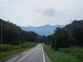
| Image:AM_Three_Top_Mountain_View_From_88.jpg|View Of Three Top Mountain coming from NC 88
| | |Icon Type=Summit |
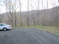
| Image:AM_Three_Top_Mountain_Trailhead.jpg|The small gravel trailhead | | |Marker Title=Big Rock (5,020 ft) |
| Image:AM_Three_Top_Mountain_Cascade.jpg|An unnamed cascade at the start
| | |Marker Description=[[Image:AM_Three_Top_Mountain_BR_View_2.jpg|150px]] |
| Image:AM_Three_Top_Mountain_HK_View_1.jpg|Looking north over the rugged ridgeline towards Phoenix Mountain.
| | |Marker Location=36.41877, -81.58890 |
| Image:AM_Three_Top_Mountain_HK_View_2.jpg|Main view of the Amphibolite Mountains south. Large peak in foreground is Big Rock. The Roan Highlands and Grandfather Mountain can all be seen here on clear days. | | }} |
| Image:AM_Three_Top_Mountain_HK_View_3.jpg|Looking towards Whitetop Mountain, Mount Rogers and the Grayson Highlands in Virginia.
| | {{Map Marker |
| Image:AM_Three_Top_Mountain_BR_Path.jpg|The start of the bushwhack towards Big Rock. Open forest all of the way.
| | |Icon Type=Summit |
| Image:AM_Three_Top_Mountain_BR_Cliffs_1.jpg|Starting the rock scramble. You are really exposed here.
| | |Marker Title=Huckleberry Rock (5,020 ft) |
| Image:AM_Three_Top_Mountain_BR_Cliffs_2.jpg|Almost there. One final push. | | |Marker Description=[[Image:AM_Three_Top_Mountain_HK_View_2.jpg|150px]] |
| Image:AM_Three_Top_Mountain_BR_Knifeedge.jpg|You don't get much more knife-edge than this
| | |Marker Location=36.42464, -81.58386 |
| Image:AM_Three_Top_Mountain_BR_View_1.jpg|Looking down the valley. Mount Jefferson sticking it's head up in the distance
| | }} |
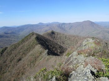
| Image:AM_Three_Top_Mountain_BR_View_2.jpg|Pretty much the entire Amphibolite Range north of Boone is visible here plus the Roan Highlands and Grandfather Mountain. | | {{Map Marker |
| Image:AM_Three_Top_Mountain_BR_View_3.jpg|Looking back at the way you came. Huckleberry Knob in the background.
| | |Icon Type=Summit |
| Image:AM_Three_Top_Mountain_BR_View_4.jpg|Bluff Mountain across the valley | | |Marker Title=Peak 4880 (4,880 ft) |
| <!-- Do not remove the end gallery code.-->
| | |Marker Location=36.41596, -81.59125 |
| </gallery>
| | }} |
| | | {{Map Marker |
| <!-- Finally add the trail to any Categories it should belong to. Please keep the State category. To make a new category just type [[Category:mycategory]]. Keep in mind categories are case sensitive. -->
| | |Icon Type=Waterfall |
| [[Category:North Carolina]] [[Category:Overlook]] [[Category:Hard]]
| | |Marker Title=Cascade |
| | |Marker Location=36.41976, -81.59665 |
| | }} |
| | {{Map Marker |
| | |Icon Type=Waterfall |
| | |Marker Title=Cascade |
| | |Marker Description=[[Image:AM_Three_Top_Mountain_Cascade.jpg|150px]] |
| | |Marker Location=36.42284, -81.59479 |
| | }} |
| | {{Map Marker |
| | |Icon Type=Parking |
| | |Marker Title=Parking for trailhead (36.42191, -81.59768) |
| | |Marker Description=[[Image:AM_Three_Top_Mountain_Trailhead.jpg|150px]] |
| | |Marker Location=36.42191, -81.59768 |
| | }} |
| | {{Map Marker |
| | |Icon Type=Trail sign |
| | |Marker Title=Start of bushwhack to Big Rock |
| | |Marker Description=[[Image:AM_Three_Top_Mountain_BR_Path.jpg|150px]] |
| | |Marker Location=36.42420, -81.58588 |
| | }} |
| | {{Map Marker |
| | |Icon Type=Point of interest |
| | |Marker Title=Navigation point |
| | |Marker Description=The best thing to do is set your car GPS to the coordinates [[http://maps.google.com/maps?q=36.42041,-81.60118 Link to Maps]] . From here, take a left and follow an old logging road not on the map the rest of way to trailhead. |
| | |Marker Location=36.42041,-81.60118 |
| | }} |
| Three Top Mountain
(log in to submit report)
|
|
|
|
| Located
|
Creston, North Carolina
|
| Trail Marking
|
Unknown
|
| Trail UseThings allowed to do on or near the trail
|

|
| FeaturesThings to see on or near the trail
|
 
|
| Difficulty Rating
|
Hard
|
| Hiking TimeTime from car and back. Includes any time hiking to access this trail.
|
4 hrs0.25 Days <br />240 Min <br /> round trip
|
| Distance:
|
1.990 mi3.203 km <br /> trailStrict non-repeating trail length / 3.98 mi6.405 km <br /> round tripTypical or shortest length from the car, hike the trail, and return to car
|
| Trail Type
|
In-and-Out
|
| Low / High Point
|
3,843 ft1,281 Yards <br />1,171.346 Meters <br /> / 5,025 ft1,675 Yards <br />1,531.62 Meters <br />
|
| Elev. Gain/LossSee link for details of calculation. Gain/Loss is direction dependent.
|
1,172 ft357.226 Meters <br /> / (36 ft10.973 Meters <br />) – West-to-East
|
| Trip ReportsFrom user "hiked it" submissions<br />Recent is within last 90 days
|
No hikes logged yet
|
| NearbyWithin 5 mi<br />Click link to view list
|
No other Trails within 5 mi
|
| Parking
|
36° 25' 18.88" N, 81° 35' 51.65" W Map
|
| Trailhead
|
36° 25' 18.88" N, 81° 35' 51.65" W Map
|
Loading map... {"type":"ROADMAP","minzoom":false,"maxzoom":false,"types":["ROADMAP","SATELLITE","HYBRID","TERRAIN"],"mappingservice":"googlemaps3","width":"100%","height":"180px","centre":false,"title":"","label":"","icon":"","lines":[],"polygons":[],"circles":[],"rectangles":[],"copycoords":false,"static":false,"visitedicon":"","wmsoverlay":false,"zoom":8,"layers":[],"controls":[""],"zoomstyle":"DEFAULT","typestyle":"DEFAULT","autoinfowindows":false,"resizable":false,"kmlrezoom":false,"poi":true,"cluster":false,"clustergridsize":60,"clustermaxzoom":20,"clusterzoomonclick":true,"clusteraveragecenter":true,"clusterminsize":2,"imageoverlays":[],"kml":[],"gkml":[],"searchmarkers":"","fullscreen":false,"scrollwheelzoom":false,"locations":[{"text":"\u003Cb\u003E\u003Cdiv class=\"mw-parser-output\"\u003E\u003Cp\u003EThree Top Mountain\n\u003C/p\u003E\u003C/div\u003E\u003C/b\u003E\u003Cdiv class=\"mw-parser-output\"\u003E\u003Cp\u003EMain Parking Location\n\u003C/p\u003E\u003C/div\u003E","title":"Three Top Mountain\n","link":"","lat":36.421909999999996898623066954314708709716796875,"lon":-81.597679999999996880433172918856143951416015625,"icon":""}]} |
| Show In Google Maps
|
Loading map...
{"format":"googlemaps3","type":"TERRAIN","minzoom":false,"maxzoom":false,"types":["SATELLITE","HYBRID","TERRAIN"],"limit":50,"offset":0,"link":"none","sort":[""],"order":[],"headers":"show","mainlabel":"","intro":"","outro":"","searchlabel":"... further results","default":"","import-annotation":false,"width":"auto","height":"600px","centre":false,"title":"","label":"","icon":"","lines":[],"polygons":[],"circles":[],"rectangles":[],"copycoords":false,"static":false,"visitedicon":"","wmsoverlay":false,"zoom":false,"layers":[],"controls":["pan","zoom","type","scale","streetview","rotate"],"zoomstyle":"DEFAULT","typestyle":"DEFAULT","autoinfowindows":false,"resizable":false,"kmlrezoom":true,"poi":true,"cluster":false,"clustergridsize":60,"clustermaxzoom":20,"clusterzoomonclick":true,"clusteraveragecenter":true,"clusterminsize":2,"imageoverlays":[],"kml":[],"gkml":["https://tehcc.org/clubwiki/images/Three_Top_Mountain.kml"],"searchmarkers":"","fullscreen":false,"scrollwheelzoom":false,"showtitle":false,"hidenamespace":true,"template":"Map Balloon Template","userparam":"","activeicon":"","pagelabel":false,"ajaxcoordproperty":"","ajaxquery":"","locations":[{"text":"\u003Cp\u003E\u003Cb\u003E\u003Ca class=\"mw-selflink selflink\"\u003EThree Top Mountain\u003C/a\u003E\u003C/b\u003E\u003Cbr /\u003E\u003C/p\u003E\u003Chr /\u003E\u003Cp\u003E1.99\u0026#160;Mi (3.20\u0026#160;km)\u003Cbr /\u003EDifficulty: Hard\u003Cbr /\u003EMarking: Unknown\u003C/p\u003E","title":"Three Top Mountain","link":"","lat":36.421909999999996898623066954314708709716796875,"lon":-81.597679999999996880433172918856143951416015625,"icon":"/clubwiki/images/MarkerT.png"},{"text":"\u003Cp\u003E\u003Cb\u003EPeak 4880 (4,880 ft)\u003C/b\u003E\u003Cbr /\u003E\u003C/p\u003E\u003Chr /\u003E\u003Cp\u003EPeak 4880 (4,880 ft)\u003C/p\u003E","title":"Three Top Mountain","link":"","lat":36.4159599999999983310772222466766834259033203125,"lon":-81.59125000000000227373675443232059478759765625,"icon":"/clubwiki/images/MarkerP.png"},{"text":"\u003Cp\u003E\u003Cb\u003ECascade\u003C/b\u003E\u003Cbr /\u003E\u003C/p\u003E\u003Chr /\u003E\u003Cp\u003E\u003Ca href=\"/wiki/File:AM_Three_Top_Mountain_Cascade.jpg\" class=\"image\"\u003E\u003Cimg alt=\"AM Three Top Mountain Cascade.jpg\" src=\"/clubwiki/images/thumb/AM_Three_Top_Mountain_Cascade.jpg/150px-AM_Three_Top_Mountain_Cascade.jpg\" decoding=\"async\" width=\"150\" height=\"113\" srcset=\"/clubwiki/images/thumb/AM_Three_Top_Mountain_Cascade.jpg/225px-AM_Three_Top_Mountain_Cascade.jpg 1.5x, /clubwiki/images/thumb/AM_Three_Top_Mountain_Cascade.jpg/300px-AM_Three_Top_Mountain_Cascade.jpg 2x\" data-file-width=\"1200\" data-file-height=\"900\" /\u003E\u003C/a\u003E\u003C/p\u003E","title":"Three Top Mountain","link":"","lat":36.42284000000000077079675975255668163299560546875,"lon":-81.5947900000000032605385058559477329254150390625,"icon":"/clubwiki/images/MarkerC.png"},{"text":"\u003Cp\u003E\u003Cb\u003ECascade\u003C/b\u003E\u003Cbr /\u003E\u003C/p\u003E\u003Chr /\u003E\u003Cp\u003ECascade\u003C/p\u003E","title":"Three Top Mountain","link":"","lat":36.419759999999996580299921333789825439453125,"lon":-81.5966499999999967940311762504279613494873046875,"icon":"/clubwiki/images/MarkerC.png"},{"text":"\u003Cp\u003E\u003Cb\u003EHuckleberry Rock (5,020 ft)\u003C/b\u003E\u003Cbr /\u003E\u003C/p\u003E\u003Chr /\u003E\u003Cp\u003E\u003Ca href=\"/wiki/File:AM_Three_Top_Mountain_HK_View_2.jpg\" class=\"image\"\u003E\u003Cimg alt=\"AM Three Top Mountain HK View 2.jpg\" src=\"/clubwiki/images/thumb/AM_Three_Top_Mountain_HK_View_2.jpg/150px-AM_Three_Top_Mountain_HK_View_2.jpg\" decoding=\"async\" width=\"150\" height=\"113\" srcset=\"/clubwiki/images/thumb/AM_Three_Top_Mountain_HK_View_2.jpg/225px-AM_Three_Top_Mountain_HK_View_2.jpg 1.5x, /clubwiki/images/thumb/AM_Three_Top_Mountain_HK_View_2.jpg/300px-AM_Three_Top_Mountain_HK_View_2.jpg 2x\" data-file-width=\"1200\" data-file-height=\"900\" /\u003E\u003C/a\u003E\u003C/p\u003E","title":"Three Top Mountain","link":"","lat":36.4246399999999965757524478249251842498779296875,"lon":-81.5838600000000013778844731859862804412841796875,"icon":"/clubwiki/images/MarkerP.png"},{"text":"\u003Cp\u003E\u003Cb\u003EStart of bushwhack to Big Rock\u003C/b\u003E\u003Cbr /\u003E\u003C/p\u003E\u003Chr /\u003E\u003Cp\u003E\u003Ca href=\"/wiki/File:AM_Three_Top_Mountain_BR_Path.jpg\" class=\"image\"\u003E\u003Cimg alt=\"AM Three Top Mountain BR Path.jpg\" src=\"/clubwiki/images/thumb/AM_Three_Top_Mountain_BR_Path.jpg/150px-AM_Three_Top_Mountain_BR_Path.jpg\" decoding=\"async\" width=\"150\" height=\"113\" srcset=\"/clubwiki/images/thumb/AM_Three_Top_Mountain_BR_Path.jpg/225px-AM_Three_Top_Mountain_BR_Path.jpg 1.5x, /clubwiki/images/thumb/AM_Three_Top_Mountain_BR_Path.jpg/300px-AM_Three_Top_Mountain_BR_Path.jpg 2x\" data-file-width=\"1200\" data-file-height=\"900\" /\u003E\u003C/a\u003E\u003C/p\u003E","title":"Three Top Mountain","link":"","lat":36.4241999999999990222931955941021442413330078125,"lon":-81.585880000000003064997144974768161773681640625,"icon":"/clubwiki/images/MarkerT.png"},{"text":"\u003Cp\u003E\u003Cb\u003ENavigation point\u003C/b\u003E\u003Cbr /\u003E\u003C/p\u003E\u003Chr /\u003E\u003Cp\u003EThe best thing to do is set your car GPS to the coordinates [\u003Ca target=\"_blank\" rel=\"nofollow noreferrer noopener\" class=\"external text\" href=\"http://maps.google.com/maps?q=36.42041,-81.60118\"\u003ELink to Maps\u003C/a\u003E] . From here, take a left and follow an old logging road not on the map the rest of way to trailhead.\u003C/p\u003E","title":"Three Top Mountain","link":"","lat":36.42040999999999684177964809350669384002685546875,"lon":-81.6011799999999993815436027944087982177734375,"icon":"/clubwiki/images/MarkerG.png"},{"text":"\u003Cp\u003E\u003Cb\u003EParking for trailhead (36.42191, -81.59768)\u003C/b\u003E\u003Cbr /\u003E\u003C/p\u003E\u003Chr /\u003E\u003Cp\u003E\u003Ca href=\"/wiki/File:AM_Three_Top_Mountain_Trailhead.jpg\" class=\"image\"\u003E\u003Cimg alt=\"AM Three Top Mountain Trailhead.jpg\" src=\"/clubwiki/images/thumb/AM_Three_Top_Mountain_Trailhead.jpg/150px-AM_Three_Top_Mountain_Trailhead.jpg\" decoding=\"async\" width=\"150\" height=\"113\" srcset=\"/clubwiki/images/thumb/AM_Three_Top_Mountain_Trailhead.jpg/225px-AM_Three_Top_Mountain_Trailhead.jpg 1.5x, /clubwiki/images/thumb/AM_Three_Top_Mountain_Trailhead.jpg/300px-AM_Three_Top_Mountain_Trailhead.jpg 2x\" data-file-width=\"1200\" data-file-height=\"900\" /\u003E\u003C/a\u003E\u003C/p\u003E","title":"Three Top Mountain","link":"","lat":36.421909999999996898623066954314708709716796875,"lon":-81.597679999999996880433172918856143951416015625,"icon":"/clubwiki/images/MarkerA.png"},{"text":"\u003Cp\u003E\u003Cb\u003EBig Rock (5,020 ft)\u003C/b\u003E\u003Cbr /\u003E\u003C/p\u003E\u003Chr /\u003E\u003Cp\u003E\u003Ca href=\"/wiki/File:AM_Three_Top_Mountain_BR_View_2.jpg\" class=\"image\"\u003E\u003Cimg alt=\"AM Three Top Mountain BR View 2.jpg\" src=\"/clubwiki/images/thumb/AM_Three_Top_Mountain_BR_View_2.jpg/150px-AM_Three_Top_Mountain_BR_View_2.jpg\" decoding=\"async\" width=\"150\" height=\"113\" srcset=\"/clubwiki/images/thumb/AM_Three_Top_Mountain_BR_View_2.jpg/225px-AM_Three_Top_Mountain_BR_View_2.jpg 1.5x, /clubwiki/images/thumb/AM_Three_Top_Mountain_BR_View_2.jpg/300px-AM_Three_Top_Mountain_BR_View_2.jpg 2x\" data-file-width=\"1200\" data-file-height=\"900\" /\u003E\u003C/a\u003E\u003C/p\u003E","title":"Three Top Mountain","link":"","lat":36.41877000000000208501660381443798542022705078125,"lon":-81.588899999999995316102285869419574737548828125,"icon":"/clubwiki/images/MarkerP.png"}]}
Download KML / Upload new version / KML File Page / Create Profile Chart / gpsvisualizer Map
Trail Overview[edit]
Three Top Mountain is an amphibolite mountain in the northwest corner of North Carolina in Ashe Country about 30 minutes north of Boone. The mountain is very unique due to its knife-edge ridgeline and sheer cliff drop offs. This is one of the most rugged mountain in NC. Due to its isolation it doesn’t get a lot of hiker traffic.
It gets its name from the 3 highest sub peaks that really stick out along its spine although there are about 11 sub peaks total. Even from the road, Three Top Mountain is impressive to look at.
Of the three sub peaks, two top out at 5,020 feet in elevation, Huckleberry Knob and Big Rock. Huckleberry Knob is considered the true summit although some have speculated that Big Rock is a little higher. If you’re a peak bagger, just hit them both just to be safe. Huckleberry Knob is very easy to get to. There is a 1.5 mile old steep ATV trail to its summit but you have to bushwhack to get to Big Rock and that’s when things get interesting.
Both Huckleberry Knob and Big Rock have spectacular 360 degree views. Big Rock not only requires a bushwhack but also a mild rock scramble at the end that is not for the faint of heart but the reward is one of the best views in all of North Carolina.
How to get there[edit]
The trailhead is difficult and confusing to find. It's actually at the end of an old logging road that is not on any map including any online maps that I'm aware of.
The best thing to do is set your car GPS to the coordinates (36.4204148356,-81.6011751636). From here, take a left and follow an old logging road not on the map the rest of way to trailhead.
I'm going to assume you’re coming via Mountain City TN on US421 to access.
- Take US421 almost to the TN/NC line at Trade TN.
- Take a left on Hwy 67 towards the east.
- Stay on Highway 67 (Highway 88, once in NC) for 13.3 miles. You'll get a good view of Three Top Mountain as you approach it.
- Turn right onto Three Top Road.
- Cross a bridge and turn left immediately, staying on Three Top Road.
- Go half a mile and turn left onto Hidden Valley Road.
- The road turns to gravel at this point.
- Continue on and you'll shortly see the Three Top game land sign.
- At this point the road name changes to Oak Trail. Just continue on for another half mile as the road goes through several switchbacks up the mountain.
- Take a right on Poplar Trail.
- When you arrive at the top ridgeline, you'll see an old logging road to your left not an any maps. Take a left and follow it for about half a mile.
- The trailhead is a large gravel circle. Trail begins at a service gate.
This final .5 mile road to the trailhead is a rough dirt road but should be passable to most vehicles. I drive a front wheel drive 2001 Honda Accord and I've never had any problems getting here.
Google Map Directions.
Bear in mind that Google Maps turn by turn method is NOT the best way to get to Three Top Mountain from Kingsport TN. Follow the above instructions but once you get onto Three Top Road (Step #4 above), the final turn by turn instructions by Google Maps are accurate to the trailhead and hopefully will take some of the confusion away from the final mile.
Route Description[edit]
Huckleberry Knob (5,020 ft)
- The route to the top from the parking area is an old ATV trail that is both steep, rocky but easy to follow.
- Orange flags and markers on trees and rocks at the start but they don't last too long
- Along the way, old roads branch off the main one but they are usually severely overgrown so you shouldn't have much trouble staying on the main path.
- Once at the summit there is a faint manway that continues along the rugged ridgeline very shortly before it fades out. A lot of fun scrambling can be had here.
- Their used to be a large American Flag on a metal pole here but it's been blown over and nobody has replaced it. If you look just below the summit you can still see the rusty old pole laying there.
Big Rock (5,020 ft)
- There is no trail to Big Rock. You have to bushwhack half a mile through open forest to get there.
- As far as bushwhacks go, this one is fairly easy. Just stick to the top of the ridgeline when possible and you shouldn't have any problems.
- At times you will notice faint paths to follow but they don't last too long before fading out.
- The last part to the top of Big Rock is a small rock scramble that can be unnerving if you have a fear of heights.
- Watch your step while on top. There are huge drops everywhere.
- Big Rock is absolutely worth the effort to get there.
| Miles
|
Three Top Mountain
|
Elevation
|
| 0.0 miles
|
Parking Area
|
3,896 feet
|
| 0.2 miles
|
Cascade
|
3,843 feet
|
| 1.65 miles
|
Arrive at Huckleberry Knob
|
5,042 feet
|
| 1.8 miles
|
Backtrack down trail to spot on ridgeline to begin bushwhack to Big Rock
|
4,928 feet
|
| 2.2 miles
|
Begin rock scramble
|
5,025 feet
|
| 2.3 miles
|
Arrive at Big Rock
|
5,042 feet
|
| 2.8 miles
|
Return to main trail back to beginning
|
4,928 feet
|
| 4.1 miles
|
Cascade
|
3,843 feet
|
| 4.3 miles
|
Parking Area
|
3,896 feet
|
Typical Conditions[edit]
Fees, Permits, etc.[edit]
Most of the mountain, including the summits, is owned by the state. The NC Wildlife Resource Commission maintain a game land of 2,808 acres. There are a number of game land access points that provide for public use of the mountain.
After the Hike[edit]
On the way back home, you won't really pass anything to stop and get some food or a drink until Mountain City.
Starting the rock scramble. You are really exposed here.
Almost there. One final push.
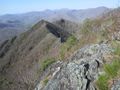
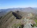
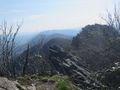
You don't get much more knife-edge than this
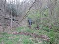
The start of the bushwhack towards Big Rock. Open forest all of the way.
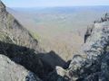
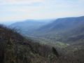
Looking down the valley. Mount Jefferson sticking it's head up in the distance
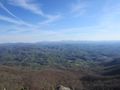
Pretty much the entire Amphibolite Range north of Boone is visible here plus the Roan Highlands and Grandfather Mountain.
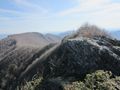
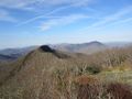
Looking back at the way you came. Huckleberry Knob in the background.
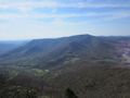
Bluff Mountain across the valley
An unnamed cascade at the start
Looking north over the rugged ridgeline towards Phoenix Mountain.
Main view of the Amphibolite Mountains south. Large peak in foreground is Big Rock. The Roan Highlands and Grandfather Mountain can all be seen here on clear days.
Looking towards Whitetop Mountain, Mount Rogers and the Grayson Highlands in Virginia.
The small gravel trailhead
View Of Three Top Mountain coming from NC 88