Template:Trail: Difference between revisions
Jump to navigation
Jump to search
(Updating trail template) |
(Updating for current format) |
||
| Line 1: | Line 1: | ||
<!-- The following few lines create the "Infobox" table template. Please scroll down to edit the main content of the article. --> | <!-- The following few lines create the "Infobox" table template. Please scroll down to edit the main content of the article. -->{{Infobox Trail | ||
{{Infobox Trail | | Image Name = | ||
| Trail Number = | |||
| Park = | |||
| City = | |||
| State = | |||
| Marking = | |||
| Trail Use = | |||
| Difficulty Rating = | |||
| Hike Time = | |||
| Round Trip Distance = | |||
| Trail Distance = | |||
| Trail Type = | |||
| Elevation Gain = | |||
| Elevation Loss = | |||
| High Point = | |||
| Parking coords = | |||
| Trailhead coords = | |||
| Medical = | |||
}}<!-- End Infobox template table--> | |||
{{Trail page needs | |||
| Hide needs = | |||
| KML = | |||
| Updated KML = | |||
| Detail route description = | |||
| Photos = | |||
| Winter photos = | |||
| Remove prefix = | |||
| Update infobox = | |||
| Infobox data update = | |||
| Trail pins = | |||
| Other = | |||
| Comment = | |||
| Date reviewed = | |||
}} | }} | ||
<!-- Start of Main Page --> | <!-- Start of Main Page --> | ||
== Trail Overview == | == Trail Overview == | ||
<!-- Enter a overview of the trail. What attracts you to this trail, points of interest, types of flowers, lakes, and peaks that you see along the way. --> | <!-- Enter a overview of the trail. What attracts you to this trail, points of interest, types of flowers, lakes, and peaks that you see along the way. --> | ||
== How to get there == | == How to get there == | ||
<!-- Please enter detailed instruction on how to find the trail head. --> | <!-- Please enter detailed instruction on how to find the trail head. --> | ||
== Route Description== | == Route Description== | ||
<!-- Detailed description of the route. Is there any side trails that are worth traveling? --> | <!-- Detailed description of the route. Is there any side trails that are worth traveling? --> | ||
{| class="wikitable" border="1" | |||
|- | |||
!Miles Out | |||
!{{PAGENAME}} | |||
!Miles Back | |||
!Elevation (ft) | |||
|- | |||
|0.0 | |||
|Trail head | |||
|2.19 | |||
|1,479 | |||
|} | |||
== Typical Conditions == | == Typical Conditions == | ||
<!-- Typical conditions throughout the year of what to expect on the trail. Rocky, muddy, sandy, flowers, lots of downed trees? --> | <!-- Typical conditions throughout the year of what to expect on the trail. Rocky, muddy, sandy, flowers, lots of downed trees? --> | ||
== Fees, Permits, etc. == | ==Fees, Permits, etc. == | ||
<!-- Please list any Fees, Permits, Regulations, etc. that may be required on this trail.--> | <!-- Please list any Fees, Permits, Regulations, etc. that may be required on this trail.--> | ||
== Misc. Information == | == Misc. Information == | ||
<!-- Enter any additional information that doesn't fit an any other fields. | <!-- Enter any additional information that doesn't fit an any other fields. Does this trail require any permits for overnight? parking? --> | ||
== Maps == | == Maps == | ||
<!-- You can place pictures, PDF's, links, or even create a Google map with your waypoints and place it here. --> | <!-- You can place pictures, PDF's, links, or even create a Google map with your waypoints and place it here. --> | ||
<display_map center="36.514327,-82.478399" type="terrain" zoom="15" width="auto" height="450" gkml="http://tehcc.org/clubwiki/kml/WPSP_sinking_water.kml"> | |||
36.516591,-82.473665~Parking and trail head~[[Image:WPSP SW parking lot.jpg|150px|Parking lot sign]]~MarkerA.png | |||
</display_map> | |||
== Photos == | == Photos == | ||
<gallery> | <gallery> | ||
<!-- Place any pictures from this trail below. | <!-- Place any pictures from this trail below. Add a picture by typing Image:imagename.extension --> | ||
Image:Sinking Waters sinkhole.jpg|The namesake sinking waters disappearing into a hole | |||
Image: | |||
<!-- Do not remove the end gallery code.--> | <!-- Do not remove the end gallery code.--> | ||
</gallery> | </gallery> | ||
<!-- Finally add the trail to any Categories it should belong to. Please keep the State category. To make a new category just type [[Category:mycategory]]. Keep in mind categories are case sensitive. | <!-- Finally add the trail to any Categories it should belong to. Please keep the State category. To make a new category just type [[Category:mycategory]]. Keep in mind categories are case sensitive. --> | ||
Revision as of 22:10, 16 October 2015
| |||||||||||||||||||||||||||||||||
Trail Overview
How to get there
Route Description
| Miles Out | Trail | Miles Back | Elevation (ft) |
|---|---|---|---|
| 0.0 | Trail head | 2.19 | 1,479 |
Typical Conditions
Fees, Permits, etc.
Misc. Information
Maps
Photos
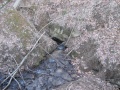
The namesake sinking waters disappearing into a hole
