Talk:Rogers Ridge Horse Trail: Difference between revisions
(first pass at a featured trail writeup) |
(→Featured Trail: preparing for use) |
||
| Line 1: | Line 1: | ||
== Featured Trail == | == Featured Trail == | ||
Rogers Ridge Horse Trail is an in-and-out 6.87 mile | [[File:Rogers Ridge Balds View 2.jpg|right|thumb|150px|Rogers Ridge Balds View]][[Rogers Ridge Horse Trail]] is an in-and-out 6.87-mile ridgeline trail. It's a long hill climb trail for a day hike, but near the end, the 360° views of the surrounding ridgelines make it all worthwhile. A side benefit of this hike is being able to reach the Tri-State Corner Knob junction of TN-NC-VA. The trail begins in the Horse Ridge Scenic Area of the Cherokee National Forest past Damascus near Laurel Bloomery, TN. Horses are allowed, but on a recent October 2015 trip, there was little evidence of them. Although clearly marked at the trail head that ATV/ORV vehicles were not allowed, signs of their recent presence were along the entire trail. | ||
The hike begins with an immediate creek crossing that has neither a bridge nor decent rocks to hop across; but this will be the last time you see water. Although guide books mention some campsites along the way with water access, we didn't see them. The trail wastes no time getting to the 3,201 feet of climbing, as it's nearly a consistent slope up to the summit. The trail itself is very well marked with yellow rectangle blazes, but several unmarked and well worn trails connect along the way. It may be that one of them connects to the [[Gentry Creek Falls]] trail that would make for a nice loop trail. The trail itself is wide with a clear "two-track" appearance and the occasional water-logged rut to walk around. While not noticed on the ascent, the descent can be challenging for the ankles, as there are several sections of loose rocks, fist-sized and smaller. | |||
After hiking for 5.33 miles with glimpses through the trees of mountains and neighboring ridgelines, you finally enter a clearing to enjoy the views. The trail may "officially" end here as the previously well-blazed path now lacks markings, but you can continue on to enjoy the views. From here you can take a side trip to the south to get an early view of the surrounding ridgelines and valley including Grandfather Mountain. Continuing on the trail to the north, you reach another bald clearing that would be suitable for camping, especially for large groups. The only reservation I myself have about camping here is the apparent frequent use of ORVs here. From this higher elevation, there are views of Whitetop Mountain and Mt Rogers Mountain to the northeast. Throughout these bald clearings, blackberry bushes appear to be growing rampant. If you can tolerate the thorns, the blackberry picking in the summer must be unlimited! | |||
In a bald clearing to the east towards the state line is the trail high point in the final bald clearing. Although various sources differ on the exact elevation, we measured by GPS at 4,900 feet. The ridgetop home seen to the south appears to have been severely vandalized. Although unfortunate for the owner, one can only hope that one day this majestic ridgeline and profile can be returned to its original natural glory. After the high point, the trail begins to descend for the first time, and ends at a trail/road. Turn left to continue the descent to find the Tri-State Corner Knob, the terminus (at least at one time) of this trail. | |||
When visited in October of 2015 the hike was an enjoyable day of near complete solitude. The only encounter was a couple in a truck near the trail terminus. Unexpectedly we found the | When visited in October of 2015, the hike was an enjoyable day of near complete solitude. The only encounter was a couple in a truck near the trail terminus. Unexpectedly we found the trees to be in the early stages of changing colors to the south and west, and found only bare trees to the north and east. Regardless, the day of fresh air, views, and exercise was more than enough to make this a great trail to visit, that you should consider as well. | ||
<gallery> | |||
Image:NC-VA-TN_Corner_triangulation_station_disk.jpg|Triangulation Disk at TN-VA-NC Corner | |||
Image:Rogers Ridge Trail View 1.jpg|View of the trail | |||
Image:Rogers Ridge Whitetop and Mt Rogers.jpg|Whitetop and Mt Rogers | |||
<!-- Do not remove the end gallery code.--> | |||
</gallery> | |||
Latest revision as of 22:48, 1 November 2015
Featured Trail[edit]

Rogers Ridge Horse Trail is an in-and-out 6.87-mile ridgeline trail. It's a long hill climb trail for a day hike, but near the end, the 360° views of the surrounding ridgelines make it all worthwhile. A side benefit of this hike is being able to reach the Tri-State Corner Knob junction of TN-NC-VA. The trail begins in the Horse Ridge Scenic Area of the Cherokee National Forest past Damascus near Laurel Bloomery, TN. Horses are allowed, but on a recent October 2015 trip, there was little evidence of them. Although clearly marked at the trail head that ATV/ORV vehicles were not allowed, signs of their recent presence were along the entire trail.
The hike begins with an immediate creek crossing that has neither a bridge nor decent rocks to hop across; but this will be the last time you see water. Although guide books mention some campsites along the way with water access, we didn't see them. The trail wastes no time getting to the 3,201 feet of climbing, as it's nearly a consistent slope up to the summit. The trail itself is very well marked with yellow rectangle blazes, but several unmarked and well worn trails connect along the way. It may be that one of them connects to the Gentry Creek Falls trail that would make for a nice loop trail. The trail itself is wide with a clear "two-track" appearance and the occasional water-logged rut to walk around. While not noticed on the ascent, the descent can be challenging for the ankles, as there are several sections of loose rocks, fist-sized and smaller.
After hiking for 5.33 miles with glimpses through the trees of mountains and neighboring ridgelines, you finally enter a clearing to enjoy the views. The trail may "officially" end here as the previously well-blazed path now lacks markings, but you can continue on to enjoy the views. From here you can take a side trip to the south to get an early view of the surrounding ridgelines and valley including Grandfather Mountain. Continuing on the trail to the north, you reach another bald clearing that would be suitable for camping, especially for large groups. The only reservation I myself have about camping here is the apparent frequent use of ORVs here. From this higher elevation, there are views of Whitetop Mountain and Mt Rogers Mountain to the northeast. Throughout these bald clearings, blackberry bushes appear to be growing rampant. If you can tolerate the thorns, the blackberry picking in the summer must be unlimited!
In a bald clearing to the east towards the state line is the trail high point in the final bald clearing. Although various sources differ on the exact elevation, we measured by GPS at 4,900 feet. The ridgetop home seen to the south appears to have been severely vandalized. Although unfortunate for the owner, one can only hope that one day this majestic ridgeline and profile can be returned to its original natural glory. After the high point, the trail begins to descend for the first time, and ends at a trail/road. Turn left to continue the descent to find the Tri-State Corner Knob, the terminus (at least at one time) of this trail.
When visited in October of 2015, the hike was an enjoyable day of near complete solitude. The only encounter was a couple in a truck near the trail terminus. Unexpectedly we found the trees to be in the early stages of changing colors to the south and west, and found only bare trees to the north and east. Regardless, the day of fresh air, views, and exercise was more than enough to make this a great trail to visit, that you should consider as well.
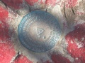
Triangulation Disk at TN-VA-NC Corner
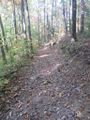
View of the trail
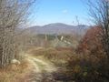
Whitetop and Mt Rogers


