Rogers Ridge Horse Trail: Difference between revisions
m (Fix top line) |
(Add pictures) |
||
| Line 1: | Line 1: | ||
<!-- The following few lines create the "Infobox" table template. Please scroll down to edit the main content of the article. -->{{Infobox Trail | <!-- The following few lines create the "Infobox" table template. Please scroll down to edit the main content of the article. -->{{Infobox Trail | ||
| Image Name = | | Image Name = Rogers Ridge Balds View 2.jpg | ||
| Trail Number = USFS 192 | | Trail Number = USFS 192 | ||
| Park = Rogers Ridge Scenic Area | | Park = Rogers Ridge Scenic Area | ||
| Line 18: | Line 18: | ||
| Trailhead coords = 36.545006,-81.738391 | | Trailhead coords = 36.545006,-81.738391 | ||
| Medical = | | Medical = | ||
}}<!-- End Infobox template table-->{{Trail page needs | }}<!-- End Infobox template table | ||
| Hide needs = | -->{{Trail page needs | ||
| Hide needs = Yes | |||
| KML = | | KML = | ||
| Updated KML = | | Updated KML = | ||
| Detail route description = | | Detail route description = | ||
| Photos = | | Photos = | ||
| Winter photos = | | Winter photos = | ||
| Remove prefix = | | Remove prefix = | ||
| Line 31: | Line 32: | ||
| Other = | | Other = | ||
| Comment = Group to Rogers Ridge Scenic Area(?) | | Comment = Group to Rogers Ridge Scenic Area(?) | ||
| Date reviewed = 10/ | | Date reviewed = 10/21/2016 | ||
}}<!-- Start of Main Page --> | }}<!-- Start of Main Page --> | ||
== Trail Overview ==<!-- Enter a overview of the trail. What attracts you to this trail, points of interest, types of flowers, lakes, and peaks that you see along the way. --> | == Trail Overview ==<!-- Enter a overview of the trail. What attracts you to this trail, points of interest, types of flowers, lakes, and peaks that you see along the way. --> | ||
| Line 180: | Line 181: | ||
<display_map center="36.567393,-81.709372" zoom="14" width="80%" type="terrain" height="700" gkml="http://tehcc.org/clubwiki/kml/Rogers_Ridge_Horse_Trail.kml"> | <display_map center="36.567393,-81.709372" zoom="14" width="80%" type="terrain" height="700" gkml="http://tehcc.org/clubwiki/kml/Rogers_Ridge_Horse_Trail.kml"> | ||
36.545006,-81.738391~Rogers Ridge Horse Trail~ ~MarkerT.png | 36.545006,-81.738391~Rogers Ridge Horse Trail~ ~MarkerT.png | ||
36.58817,-81.67745~triangulation station disk for NC-TN-VA Corner~ ~MarkerG.png | 36.58817,-81.67745~triangulation station disk for NC-TN-VA Corner~[[Image:NC-VA-TN_Corner_triangulation_station_disk.jpg|150px|Triangulation Disk at TN-VA-NC Corner]]~MarkerG.png | ||
36.546588,-81.736871~Unknown trail connection~Possibly to B&B~MarkerT.png | 36.546588,-81.736871~Unknown trail connection~Possibly to B&B~MarkerT.png | ||
36.548921,-81.729925~Unknown trail connection~ ~MarkerT.png | 36.548921,-81.729925~Unknown trail connection~ ~MarkerT.png | ||
| Line 190: | Line 191: | ||
36.577901,-81.701285~Camping spots~ ~MarkerH.png | 36.577901,-81.701285~Camping spots~ ~MarkerH.png | ||
36.579767,-81.695788~Unknown trail connection~Possibly to reach the balds sooner~MarkerT.png | 36.579767,-81.695788~Unknown trail connection~Possibly to reach the balds sooner~MarkerT.png | ||
36.583194,-81.694727~Balds clearing~ ~MarkerG.png | 36.583194,-81.694727~Balds clearing~[[Image:Rogers Ridge Balds Hiking.jpg|150px|View of the balds]]~MarkerG.png | ||
36.583653,-81.695250~Trail connection~Possible official Rogers Ridge Terminus?~MarkerT.png | 36.583653,-81.695250~Trail connection~[[Image:Rogers Ridge Possible Terminus.jpg|150px|Possible official Rogers Ridge Terminus?]]~MarkerT.png | ||
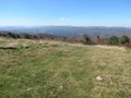
36.581568,-81.696920~Overlook~ ~MarkerE.png | 36.581568,-81.696920~Overlook~[[Image:Rogers Ridge Trail View 1.jpg|150px|View of the trail]]~MarkerE.png | ||
36.588834,-81.690322~Overlook~ ~MarkerE.png | 36.588834,-81.690322~Overlook~[[Image:Rogers Ridge Balds View 4.jpg|150px|View from the balds]]~MarkerE.png | ||
36.588367,-81.688673~Camping spot and horse hitching posts~ ~MarkerH.png | 36.588367,-81.688673~[[Image:Rogers Ridge Hitching Posts.jpg|150px|Camping spot and horse hitching posts]]~ ~MarkerH.png | ||
36.587477,-81.682953~Trail high point~ ~MarkerD.png | 36.587477,-81.682953~Trail high point~ ~MarkerD.png | ||
36.584771,-81.679070~Trail/Road Junction~ ~MarkerT.png | 36.584771,-81.679070~Trail/Road Junction~ ~MarkerT.png | ||
| Line 204: | Line 205: | ||
<!-- Add a picture by typing Image:imagename.extension --> | <!-- Add a picture by typing Image:imagename.extension --> | ||
Image:NC-VA-TN_Corner_triangulation_station_disk.jpg|Triangulation Disk at TN-VA-NC Corner | Image:NC-VA-TN_Corner_triangulation_station_disk.jpg|Triangulation Disk at TN-VA-NC Corner | ||
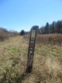
Image:Rogers Ridge ATV sign.jpg|ATV's banned on Rogers Ridge | |||
Image:Rogers Ridge Balds Hiking.jpg|View of the balds | |||
Image:Rogers Ridge Balds View 1.jpg|View from the balds | |||
Image:Rogers Ridge Balds View 2.jpg|View from the balds | |||
Image:Rogers Ridge Balds View 3.jpg|View from the balds | |||
Image:Rogers Ridge Balds View 4.jpg|View from the balds | |||
Image:Rogers Ridge Blaze.jpg|Blaze | |||
Image:Rogers Ridge Hitching Posts.jpg|Horse hitching posts atop the balds | |||
Image:Rogers Ridge Initial Stream crossing.jpg|Initial stream crossing | |||
Image:Rogers Ridge Possible Terminus.jpg|Possible terminus | |||
Image:Rogers Ridge Rocky Trail.jpg|Difficult terrain | |||
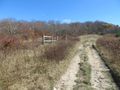
Image:Rogers Ridge Trail Head.jpg|Trail head | |||
Image:Rogers Ridge Trail View 1.jpg|View of the trail | |||
Image:Rogers Ridge Trail View 2.jpg|View of the trail | |||
Image:Rogers Ridge Trail View 3.jpg|View of the trail | |||
Image:Rogers Ridge Whitetop and Mt Rogers.jpg|Whitetop and Mt Rogers | |||
<!-- Do not remove the end gallery code.--> | <!-- Do not remove the end gallery code.--> | ||
</gallery> | </gallery> | ||
Revision as of 23:48, 21 October 2015
| |||||||||||||||||||||||||||||||||||||||||||||

Trail Overview
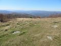
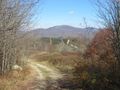
A long ridge hike with incredible views along the way that is then dwarfed by the commanding views at 4,440' and another at 4,770' upon the balds near the end offering 360° views of the surrounding area. The views include Grandfather Mountain to the south and Whitetop and Mt Rogers to the North-East. The ending is a bonus view of the VA-TN-NC Tri-State Corner Knob unceremoniously marked with a simple surveying disk.
How to get there
From Kingsport, TN:
- Take I-81 north to Exit 19 for US-58 towards Damascus.
- Continue through Damascus.
- Take right (south) when VA-91 and US-58 split.
- Proceed back into Tennessee to Laurel Bloomery.
From Mountain City, TN:
- Proceed north on TN 91 for 7.7 miles to Laurel Bloomery.
Then for both routes:
- Turn at the A-Z Market onto Gentry Creek Road (sign to Pleasant Home Church) and proceed 0.8 miles.
- Make right turn onto Star Gap Road.
- Then quickly left again ton continue on Gentry Creek Road, which become gravel after 1.1 miles.
- Shortly after becoming gravel, the trail head and parking area are on the left
The road continues to the right to the dead end cul-de-sac with a trail marker for Gentry Creek Falls trail.
Route Description
The trail is mostly well blazed with yellow rectangles, never leaving confusion as to the proper direction at trail junctions. This is true until shortly after entering the bald clearing when the trail dead-ends into another trail. Although a sign signified the way we came was Rogers Ridge Horse Trail, it gave no indication of the path to continue. Additionally the yellow blazes stopped here. This may be the "official" end of the Rogers Ridge Horse Trail. Horse trail markers mentioned in old books were also never seen at any point along the trail.
The trail begins at the sign with a creek crossing. Horse hitching posts and campsites are also near the trail head. After the creek fording, it is an uphill climb most of the way. It quickly reaches a ridge and follows near it most of the way. Once it opens up to grassy fields, the views are splendid. Trail/road swings right to go almost east for about a half mile to the state line. A left turn past the summit leads down to the Tri-State Corner Knob of TN-VA-NC.
| Miles Out | Rogers Ridge Horse Trail | Miles Back | Elevation (ft) |
|---|---|---|---|
| 0.0 | Trail head at parking spot | 6.87 | 2,766 |
| 0.31 | Unknown trail connection to the left, possibly to the B&B observed just before the trail head | 6.56 | 2,865 |
| 0.85 | Unknown trail connection to the left | 6.02 | 3,211 |
| 3.55 | Unknown trail connection to the right | 3.32 | 3,966 |
| 3.77 | Unknown trail connection to the right | 3.10 | 3,957 |
| 3.90 | Multi-(unknown) trail junction, continue right | 2.97 | 3,962 |
| 3.99 | Unknown trail connection to the right | 2.88 | 4,066 |
| 4.52 | Trail junction in small clearing | 2.35 | 4,039 |
| 4.70 | Camping spots on left | 2.17 | 4,121 |
| 5.07 | Unknown trail connection on the left, possibly to reach the balds sooner | 1.80 | 4,373 |
| 5.33 | Enter the balds | 1.54 | 4,438 |
| 5.38 | Trail junction, possible official end of Rogers Ridge Trail, continue right to Tri-State Corner Knob, head left for 0.2 Mi hike to an open bald view | 1.49 | 2,766 |
| 5.79 | Trail splits for several approaches up the bald, shortcut to the right, stay left for a peak view | 1.08 | 4,724 |
| 5.85 | Bald overlook | 1.02 | 4,771 |
| 5.96 | Horse hitching posts, not the worlds most ineffective fence as one author suggested | 0.91 | 4,761 |
| 6.10 | Open road gate | 0.77 | 4,861 |
| 6.31 | Trail high point in a bald clearing | 0.56 | 4,900 |
| 6.60 | Trail/road junction, head left to Tri-State Corner Knob, right is private property up to the ridge house | 0.27 | 4,800 |
| 6.87 | The Tri-State Corner Knob | 0.00 | 4,633 |
Typical Conditions
The trail began with a well flowing creek no provision for a dry crossing. These hikers in October opted for a barefoot crossing to avoid risking a long hike starting with wet feet.
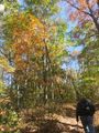
The trail is nice and wide suiting well for group hikes. There is the occasional ORV rut to walk around. The trail includes several sections of loose large rock around first sized and smaller. Although not noticed on the ascent, the return descent was a challenge for the ankles.
On an October Saturday during near peak fall color when hikers to vast overlooks would be most expected, the hike was near complete solitude from people and noise. The only encounter was a truck driving by near the Tri-State Knob terminus.
Misc. Information
Several of the hike descriptions found online and in books appear to be vastly out of date. Many notes of passing old structures, abandoned buses, and other trail features were simply not seen in 2015. It is suspected that either major cleanup had happened, or the trail has been rerouted in the intervening years.
The house on the peak near the Tri-State Knob built in the early 1990's has been severely vandalized. Maybe one day the ridge line will be restored to its natural beauty. Online investigations revealed that the property was originally part of a 175 acre tract, but in 2010 all but around 15 acres were conveyed to the State of North Carolina. The house (and therefore ridge line) remains on a privately owned 10 acre tract straddling the TN-NC state line.
Maps
Photos
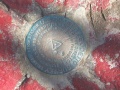
Triangulation Disk at TN-VA-NC Corner
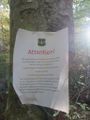
ATV's banned on Rogers Ridge
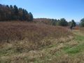
View of the balds
View from the balds
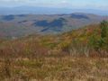
View from the balds
View from the balds
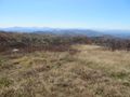
View from the balds
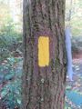
Blaze
Horse hitching posts atop the balds
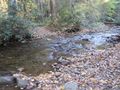
Initial stream crossing
Possible terminus
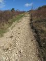
Difficult terrain
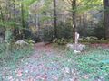
Trail head
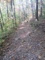
View of the trail
View of the trail
- Rogers Ridge Trail View 3.jpg
View of the trail
Whitetop and Mt Rogers


