Rogers Ridge Horse Trail: Difference between revisions
(→Maps: Recenter and zoom map) |
|||
| Line 62: | Line 62: | ||
== Typical Conditions == | == Typical Conditions == | ||
<!-- Typical conditions throughout the year of what to expect on the trail. Rocky, muddy, sandy, flowers, lots of downed trees? --> | <!-- Typical conditions throughout the year of what to expect on the trail. Rocky, muddy, sandy, flowers, lots of downed trees? --> | ||
The trail began with a well flowing creek in October and no provision for a dry crossing. These hikers opted for a barefoot crossing to avoid risking a long hike starting with wet feet. | |||
The trail is nice and wide suiting well for group hikes. There is the occasional ORV rut to walk around. The trail includes several sections of loose large rock around first sized and smaller. Although not noticed on the ascent, the return really wore on the ankles. | |||
On an October Saturday during near peak fall color when hikers to vast overlooks would be most expected, the hike was near complete solitude from people and noise. The only encounter was a truck driving by near the Tri-Corner Knob terminus. | |||
==Fees, Permits, etc. == | ==Fees, Permits, etc. == | ||
Revision as of 22:55, 17 October 2015
| |||||||||||||||||||||||||||||||||||||||||||||
== Trail Overview ==
Open grassy ridge at 4,628 ft of elevation with triangulation station disk at corner of Virginia, Tennessee and North Carolina
How to get there
From Kingsport, TN:
- Take I-81 north to Exit 19 for US-58 towards Damascus.
- Continue through Damascus.
- Take right (south) when VA-91 and US-58 split.
- Proceed back into Tennessee to Laurel Bloomery.
From Mountain City, TN:
- Proceed north on TN 91 for 7.7 miles to Laurel Bloomery.
Then for both routes:
- Turn at the A-Z Market onto Gentry Creek Road (sign to Pleasant Home Church) and proceed 0.8 miles.
- Make right turn onto Star Gap Road.
- Then quickly left again ton continue on Gentry Creek Road, which become gravel after 1.1 miles.
- Continue on rough gravel road for 1.4 miles and park at road end.
Point of information is that the first cul-de-sac parking lot reached on the gravel road is for Rogers Ridge Horse Trail. Veer to the right to continue back to the dead end cul-de-sac with a trail marker for Gentry Creek Falls trail.
Route Description
Since the trail is a horse trail, it starts with a creek ford but soon it is an uphill climb. It reaches a ridge and follows near it most of the way. At a fairly high point, it sort of goes through the yard of a house and then continues through woods a short distance to a road, which then leads on to the summit and beyond. Once it opens up to grassy fields, the views are splendid. Trail/road swings right to go almost east for about a half mile to the state line. A left turn past the summit leads down perhaps 100 yards to the marked tricorner point of VA-Tenn-NC.
A point of caution, when returning stay together to be sure to turn off the road where the trail starts.
Typical Conditions
The trail began with a well flowing creek in October and no provision for a dry crossing. These hikers opted for a barefoot crossing to avoid risking a long hike starting with wet feet.
The trail is nice and wide suiting well for group hikes. There is the occasional ORV rut to walk around. The trail includes several sections of loose large rock around first sized and smaller. Although not noticed on the ascent, the return really wore on the ankles.
On an October Saturday during near peak fall color when hikers to vast overlooks would be most expected, the hike was near complete solitude from people and noise. The only encounter was a truck driving by near the Tri-Corner Knob terminus.
Fees, Permits, etc.
After the Hike
Misc. Information
Maps
Photos
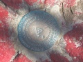
Triangulation Disk at TN-VA-NC Corner
