Rock Creek Falls: Difference between revisions
m (cleanup IB data) |
(converting to new page style - first pass) |
||
| Line 1: | Line 1: | ||
{{Trail | |||
|Trail Highlight=An easy short trail to a remote and beautiful waterfall | |||
|Trail Number=FS #115 | |||
|Park=Rock Creek Recreation Area | |||
|Land Owner=Cherokee National Forest | |||
|Trail Marking=Blue | |||
|Trail Use=Hiking, Camping, Hunting | |||
|Trail Features=Waterfalls | |||
|Difficulty Rating=Easy | |||
|Hike Time=4 hrs | |||
|Trail Distance=1.52 mi | |||
|Round Trip Distance=3.04 mi | |||
|Trail Type=In-and-Out | |||
|High Point=3,263 ft | |||
|Low Point= | |||
|Elevation Gain= | |||
|Elevation Loss= | |||
|Elevation Change Direction=West-to-East | |||
|Parking location=36.1384,-82.3499 | |||
|Trailhead location=36.13903,-82.34398 | |||
}} | |||
{{Trail Map}} | |||
__TOC__ | |||
== Trail Overview == | == Trail Overview == | ||
Accessed from [[Rock Creek Recreation Area]]. Parking fees apply. See park page for details. | |||
== How to get there == | == How to get there == | ||
From Erwin, TN | From Erwin, TN | ||
#Take Exit 36 off I-26. | #Take Exit 36 off I-26. | ||
| Line 62: | Line 39: | ||
== Route Description== | == Route Description== | ||
Walk the paved road through campground or alternately take the new bypass trail around. The trailhead is behind the tent camping area. Forest Service Trail #148 Rock Creek Falls follows the Rock Creek as it winds up the hollow. Do not cross either the bridge at the trailhead nor the one shortly up the trail as these are for a mountain bike loop. Just past the second bridge, you'll see signs for entering the Unaka Wilderness area. You'll pass several smaller falls and cascades on the way to the main falls located in a secluded, rocky amphitheater. | Walk the paved road through campground or alternately take the new bypass trail around. The trailhead is behind the tent camping area. Forest Service Trail #148 Rock Creek Falls follows the Rock Creek as it winds up the hollow. Do not cross either the bridge at the trailhead nor the one shortly up the trail as these are for a mountain bike loop. Just past the second bridge, you'll see signs for entering the Unaka Wilderness area. You'll pass several smaller falls and cascades on the way to the main falls located in a secluded, rocky amphitheater. | ||
== Typical Conditions == | == Typical Conditions == | ||
The blue blazed trail can be narrow, rough, and steep as work your way up Rock Creek. There are four creek crossings which were easily "rock hopped" as folks have been placing stepping stones. Otherwise, recommend bringing water shoes to protect feet on the possibly slippery rocks. It will take a couple of hours to hike up the trail depending upon how quickly you can cross the creek - and stops to observe the mountain hollow and cascading stream. | The blue blazed trail can be narrow, rough, and steep as work your way up Rock Creek. There are four creek crossings which were easily "rock hopped" as folks have been placing stepping stones. Otherwise, recommend bringing water shoes to protect feet on the possibly slippery rocks. It will take a couple of hours to hike up the trail depending upon how quickly you can cross the creek - and stops to observe the mountain hollow and cascading stream. | ||
==Fees, Permits, etc. == | ==Fees, Permits, etc. == | ||
Rock Creek Campground is open May 1 through November 1. Campground gates are closed from 10 PM until 7 AM. If closed, then add a mile to hike in from the main gate. Day use area fee is $2 per car. Permit must be visibly displayed in vehicle. Wilderness designated area, thus group size is limited to 14 people. Dogs are allowed, but must remain on a 6 ft or shorter leash. | Rock Creek Campground is open May 1 through November 1. Campground gates are closed from 10 PM until 7 AM. If closed, then add a mile to hike in from the main gate. Day use area fee is $2 per car. Permit must be visibly displayed in vehicle. Wilderness designated area, thus group size is limited to 14 people. Dogs are allowed, but must remain on a 6 ft or shorter leash. | ||
== Misc. Information == | == Misc. Information == | ||
Trail distance on the kiosk says 2.5 miles, but only 1.52 miles measured. | Trail distance on the kiosk says 2.5 miles, but only 1.52 miles measured. | ||
== Photos == | == Photos == | ||
{{Park trail gallery|Trail={{PAGENAME}}}} | |||
{{Map Marker|Icon Type=Parking|Marker Title=Parking|Marker Description= |Marker Location=36.1384,-82.3499}} | |||
[[ | {{Map Marker|Icon Type=Point of interest|Marker Title=Trailhead|Marker Description= |Marker Location=36.13903,-82.34398}} | ||
{{Map Marker|Icon Type=Waterfall|Marker Title=Upper Falls|Marker Description=[[File:Rock_Creek_Falls.jpg|150px|Upper Rock Creek Falls]]|Marker Location=36.12722,-82.32295}} | |||
Revision as of 10:21, 19 September 2021
| Rock Creek Falls (log in to submit report) | |
|---|---|
| Highlight | An easy short trail to a remote and beautiful waterfall |
| Trail Number | FS #115 |
| Park | Rock Creek Recreation Area |
| Land Owner | Cherokee National Forest |
| Located | Erwin, TennesseeLocation inherited from associated park |
| Trail Marking | Blue |
| Trail UseThings allowed to do on or near the trail |
|
| FeaturesThings to see on or near the trail |
|
| Difficulty Rating | Easy |
| Hiking TimeTime from car and back. Includes any time hiking to access this trail. | 4 hrs0.25 Days <br />240 Min <br /> round trip |
| Distance: | 1.52 mi2.446 km <br /> trailStrict non-repeating trail length / 3.04 mi4.892 km <br /> round tripTypical or shortest length from the car, hike the trail, and return to car |
| Trail Type | In-and-Out |
| High Point | 3,263 ft1,087.667 Yards <br />994.562 Meters <br /> |
| Elev. Gain/LossSee link for details of calculation. Gain/Loss is direction dependent. | / () – West-to-East |
| Trip ReportsFrom user "hiked it" submissions<br />Recent is within last 90 days | No hikes logged yet |
| NearbyWithin 5 mi<br />Click link to view list | 2 trails / 15.3 mi of trail |
| Parking | 36° 8' 18.24" N, 82° 20' 59.64" W Map |
| Trailhead | 36° 8' 20.51" N, 82° 20' 38.33" W Map |
|
| |
| Show In Google Maps | |
Download KML / Upload new version / KML File Page / Create Profile Chart / gpsvisualizer Map
Trail Overview
Accessed from Rock Creek Recreation Area. Parking fees apply. See park page for details.
How to get there
From Erwin, TN
- Take Exit 36 off I-26.
- Turn left on unnamed road across the interstate to intersection with Tenn. 107 in Erwin.
- Turn right on Tenn. 107 for about a mile.
- Turn left on Tenn. 395 (USFS sign to Beauty Spot).
- Proceed 3.2 miles.
- Turn left into the USFS Rock Creek Recreation Area.
- Park near restrooms at Picnic Area.
Same as for Rattlesnake Ridge Trail
Route Description
Walk the paved road through campground or alternately take the new bypass trail around. The trailhead is behind the tent camping area. Forest Service Trail #148 Rock Creek Falls follows the Rock Creek as it winds up the hollow. Do not cross either the bridge at the trailhead nor the one shortly up the trail as these are for a mountain bike loop. Just past the second bridge, you'll see signs for entering the Unaka Wilderness area. You'll pass several smaller falls and cascades on the way to the main falls located in a secluded, rocky amphitheater.
Typical Conditions
The blue blazed trail can be narrow, rough, and steep as work your way up Rock Creek. There are four creek crossings which were easily "rock hopped" as folks have been placing stepping stones. Otherwise, recommend bringing water shoes to protect feet on the possibly slippery rocks. It will take a couple of hours to hike up the trail depending upon how quickly you can cross the creek - and stops to observe the mountain hollow and cascading stream.
Fees, Permits, etc.
Rock Creek Campground is open May 1 through November 1. Campground gates are closed from 10 PM until 7 AM. If closed, then add a mile to hike in from the main gate. Day use area fee is $2 per car. Permit must be visibly displayed in vehicle. Wilderness designated area, thus group size is limited to 14 people. Dogs are allowed, but must remain on a 6 ft or shorter leash.
Misc. Information
Trail distance on the kiosk says 2.5 miles, but only 1.52 miles measured.
Photos
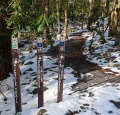
Trailhead with Rock Creek Falls - Photo by Dennis Mott (Feb 2010)
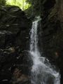
Falls
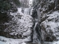
Frozen Falls


