Rock City: Difference between revisions
Jump to navigation
Jump to search
(→Maps: New trail map) |
(add banner image choice) |
||
| (2 intermediate revisions by the same user not shown) | |||
| Line 1: | Line 1: | ||
{{Trail | |||
|Banner Image=File:WPSP Fall Creek Falls - Rock City.jpg | |||
|Trail System=Warriors' Path State Park Mountain Bike Trails | |||
|Park=Warriors' Path State Park | |||
|Trail Marking=Black | |||
|Trail Use=Hiking, Biking | |||
|Trail Features=Vistas, Rivers | |||
|Difficulty Rating=Medium | |||
|Hike Time=1 hr | |||
|Trail Distance=0.5 mi | |||
|Round Trip Distance=1.0 mi | |||
|Trail Type=Segment | |||
|High Point=1,557 Ft | |||
|Low Point=1,265 ft | |||
|Elevation Gain=289 Ft | |||
|Elevation Loss=233 Ft | |||
|Elevation Change Direction=Clockwise | |||
|Parking location=36.49213, -82.46857 | |||
|Trailhead location=36.49213, -82.46857 | |||
}} | |||
{{Trail Map}} | |||
__TOC__ | |||
== Trail Overview == | == Trail Overview == | ||
<!-- Enter a overview of the trail. What attracts you to this trail, points of interest, types of flowers, lakes, and peaks that you see along the way. --> | <!-- Enter a overview of the trail. What attracts you to this trail, points of interest, types of flowers, lakes, and peaks that you see along the way. --> | ||
| Line 66: | Line 48: | ||
<!-- Please list any Fees, Permits, Regulations, etc. that may be required on this trail.--> | <!-- Please list any Fees, Permits, Regulations, etc. that may be required on this trail.--> | ||
No fee required. Dogs are allowed on or off leash. Do not drink any water without treatment! | No fee required. Dogs are allowed on or off leash. Do not drink any water without treatment! | ||
== Photos == | == Photos == | ||
{{Park trail gallery|Trail={{PAGENAME}}}} | |||
Latest revision as of 12:58, 26 December 2019
| Rock City (log in to submit report) | |
|---|---|

| |
| Trail System | Warriors' Path State Park Mountain Bike Trails |
| Park | Warriors' Path State Park |
| Located | Kingsport, TennesseeLocation inherited from associated park |
| Trail Marking | Black |
| Trail UseThings allowed to do on or near the trail |
|
| FeaturesThings to see on or near the trail |
|
| Difficulty Rating | Medium |
| Hiking TimeTime from car and back. Includes any time hiking to access this trail. | 1 hr0.0625 Days <br />60 Min <br /> round trip |
| Distance: | 0.5 mi0.805 km <br /> trailStrict non-repeating trail length / 1.0 mi1.609 km <br /> round tripTypical or shortest length from the car, hike the trail, and return to car |
| Trail Type | Segment |
| Low / High Point | 1,265 ft421.667 Yards <br />385.572 Meters <br /> / 1,557 Ft519 Yards <br />474.574 Meters <br /> |
| Elev. Gain/LossSee link for details of calculation. Gain/Loss is direction dependent. | 289 Ft88.087 Meters <br /> / (233 Ft71.018 Meters <br />) – Clockwise |
| Trip ReportsFrom user "hiked it" submissions<br />Recent is within last 90 days | 2 logged hikes (0 recent) |
| NearbyWithin 5 mi<br />Click link to view list | 20 trails / 17.7 mi of trail |
| Parking | 36° 29' 31.67" N, 82° 28' 6.85" W Map |
| Trailhead | 36° 29' 31.67" N, 82° 28' 6.85" W Map |
|
| |
| Show In Google Maps | |
Trail Overview[edit]
Located in Warriors Path State Park.
How to get there[edit]
From main entrance of Warriors Path State Park:
- Go north on Fall Creek Road for 2.4 miles.
- Turn right (east) onto Old Mill Road for 0.8 miles.
- Turn right (south) onto Childress Ferry Road for just roughly 100 yards.
- Turn left (east) onto Buttermilk Road for 1.2 miles.
- Turn right (south) onto Freeman Road for 0.5 mile.
- Continue when road changes from asphalt to gravel.
Trailhead at gravel parking lot.
Route Description[edit]
Typical Conditions[edit]
The mountain biking association SORBA Tri-Cities handles the trail maintenance, thus generally in good condition. While there are no blazes to guide you through the forest, the narrow single tracks are well established. Grab a trail map at the parking lot kiosk to help you decipher intersections; some which could use signs. Be aware for approaching bike riders who can come up quickly on your group. Step aside to let them safely pass.
Fees, Permits, etc.[edit]
No fee required. Dogs are allowed on or off leash. Do not drink any water without treatment!
Photos[edit]
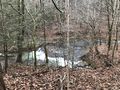
View of Fall Creek Falls
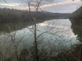
Overlook view of Fall Creek Rd Bridge
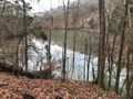
View of inlet

