|
|
| (5 intermediate revisions by 2 users not shown) |
| Line 1: |
Line 1: |
| <!-- The following few lines create the "Infobox" table template. Please scroll down to edit the main content of the article.
| | {{Trail |
| | |Banner Image=File:Roaring Branch waterfall.JPG |
| | |Trail Highlight=Starting waterfall, view of the Powell River Valley |
| | |City=Big Stone Gap |
| | |Trail Marking=Yellow |
| | |Trail Use=Hiking |
| | |Trail Features=Waterfalls, Vistas |
| | |Difficulty Rating=Hard |
| | |Hike Time=7 hrs |
| | |Trail Distance=3.868 mi |
| | |Round Trip Distance=7.736 mi |
| | |Trail Type=In-and-Out |
| | |High Point=3,042 ft |
| | |Low Point=1,581 ft |
| | |Elevation Gain=1,529 ft |
| | |Elevation Loss=-70 ft |
| | |Elevation Change Direction=East-to-West |
| | |Parking location=36.88367, -82.78789 |
| | |Trailhead location=36.88367, -82.78789 |
| | }} |
| | {{Trail Map}} |
|
| |
|
| -->{{Infobox Trail
| | __TOC__ |
| | Image Name = Roaring Branch waterfall.JPG
| |
| | City = Big Stone Gap/ Appalachia
| |
| | State = Virginia
| |
| | Marking = Yellow
| |
| | Trail Use = {{Hike}} {{Waterfall}}
| |
| | Difficulty Rating = Hard
| |
| | Hike Time = 6.5-7
| |
| | Distance = 8.0
| |
| | Elevation Gain = 1420
| |
| | High Point = 2810
| |
| | Latitude = 36.88367
| |
| | Longitude = -82.78789
| |
| | Medical = Big Stone Gap, VA
| |
| }}<!--
| |
|
| |
|
| End Infobox template table
| |
|
| |
| -->{{Trail page needs
| |
| | Hide needs =
| |
| | KML =
| |
| | Updated KML =
| |
| | Detail route description =
| |
| | Photos =
| |
| | Winter photos =
| |
| | Remove prefix =
| |
| | Update infobox = Yes
| |
| | Infobox data update = Yes
| |
| | Trail pins =
| |
| | Other =
| |
| | Comment =
| |
| | Date reviewed = 11/22/2015
| |
| }}<!--
| |
|
| |
| Start of Main Page -->
| |
| == Trail Overview == | | == Trail Overview == |
| <!-- Enter a overview of the trail. What attracts you to this trail, points of interest, types of flowers, lakes, and peaks that you see along the way. -->
| |
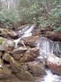
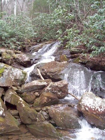
| Begin at a cascading waterfall. Hike up along the creek through forest. Climb the ridge line up to a rocky overlook for the Powell River valley. All within the Stone Mountain section of Jefferson National Forest. | | Begin at a cascading waterfall. Hike up along the creek through forest. Climb the ridge line up to a rocky overlook for the Powell River valley. All within the Stone Mountain section of Jefferson National Forest. |
|
| |
|
| Line 52: |
Line 38: |
|
| |
|
| == Route Description== | | == Route Description== |
| <!-- Detailed description of the route. Is there any side trails that are worth traveling? -->
| | [[File:Roaring branch trail profile.png|thumb|right|Profile chart]] |
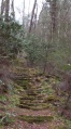
| After admiring the Roaring Branch waterfall, proceed up stone stairs created by youth conservation corps. Follow yellow blazed trail as the path continues along the stream through the forest. Multiple stream crossings - some may be very difficult after heavy rain. Proceed up ridge line to High Butte overlook. (Great spot for lunch.) Reverse direction back to trailhead. | | After admiring the Roaring Branch waterfall, proceed up stone stairs created by youth conservation corps. Follow yellow blazed trail as the path continues along the stream through the forest. Multiple stream crossings - some may be very difficult after heavy rain. Proceed up ridge line to High Butte overlook. (Great spot for lunch.) Reverse direction back to trailhead. |
|
| |
|
| Line 114: |
Line 100: |
| == Typical Conditions == | | == Typical Conditions == |
| <!-- Typical conditions throughout the year of what to expect on the trail. Rocky, muddy, sandy, flowers, lots of downed trees? --> | | <!-- Typical conditions throughout the year of what to expect on the trail. Rocky, muddy, sandy, flowers, lots of downed trees? --> |
| As reported by the NFS Ranger, the trail, primarily in the first mile and half, was cleared by volunteers of many blowdowns from the 2009 winter damage. Someone has marked with stakes and begun installing rock and log waterbars to address water flow down the trail path.
| | '''*** July 2020 *** Current reports are that first 2-2.5 miles are in bad/unmaintained condition with lots of downed trees and overgrowth.''' |
|
| |
|
| Several creek crossings. The first encountered can be made by rock hopping unless the water level is up due to heavy rain, then a nearby fallen tree might provide a bridge. Others will require figuring out where to step to not sink into soft mud. The creek crossing right in front of a campsite in the trail path required us to remove boots and wade. | | Several creek crossings. The first encountered can be made by rock hopping unless the water level is up due to heavy rain, then a nearby fallen tree might provide a bridge. Others will require figuring out where to step to not sink into soft mud. The creek crossing right in front of a campsite in the trail path required us to remove boots and wade. |
| Line 127: |
Line 113: |
| <!-- Other things to check out while you're in the area. Restaurants, attractions, monuments, etc... --> | | <!-- Other things to check out while you're in the area. Restaurants, attractions, monuments, etc... --> |
| For refreshment, there is a DQ in Big Stone Gap and a McD's at the turn for US23 heading home. | | For refreshment, there is a DQ in Big Stone Gap and a McD's at the turn for US23 heading home. |
|
| |
| == Misc. Information ==
| |
| <!-- Enter any additional information that doesn't fit an any other fields. -->
| |
|
| |
| == Maps ==
| |
| <!-- You can place pictures, PDF's, links, or even create a Google map with your waypoints and place it here. -->
| |
| <display_map center="36.87,-82.816" type="terrain" zoom="13" width="auto" height="350" scale="yes" gkml="http://tehcc.org/clubwiki/kml/Roaring_Branch_Trail.kml">
| |
|
| |
| 36.88367,-82.78789~ ~[[File:Roaring Branch Trailhead.JPG|150px|Trailhead sign with no trail name]]~MarkerA.png
| |
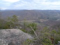
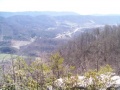
| 36.85002, -82.83458~ ~[[File:High Butte.jpg|150px|High Butte Overlook into Powell Valley]]~MarkerE.png
| |
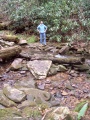
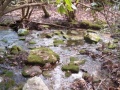
| 36.87819,-82.79517~Creek Crossing~[[File:Roaring Branch Trail - first creek crossing.JPG|150px|First creek crossing]]~MarkerJ.png
| |
| 36.87550,-82.80042~Creek Crossing~ ~MarkerJ.png
| |
| 36.86806,-82.80827~Creek Crossing~ ~MarkerJ.png
| |
| 36.86592,-82.81091~Creek Crossing~ ~MarkerJ.png
| |
| 36.86594,-82.81046~Creek Crossing~ ~MarkerJ.png
| |
| 36.87606,-82.79976~Creek Crossing~ ~MarkerJ.png
| |
| </display_map>
| |
|
| |
| [[File:Roaring Branch Trail profile.JPG]]
| |
|
| |
|
| == Photos == | | == Photos == |
| <gallery>
| | {{Park trail gallery|Trail={{PAGENAME}}}} |
| <!-- Place any pictures from this trail below. Add a picture by typing Image:imagename.extension -->
| | {{Map Marker |
| Image:Roaring Branch Trailhead.JPG|Trailhead sign with no trail name
| | |Icon Type=Parking |
| Image:Roaring Branch Trail - stone steps.JPG|Stone steps by youth conservation corps in 1970s
| | |Marker Title=Trailhead |
| Image:High Butte.jpg|High Butte Overlook into Powell Valley
| | |Marker Description=[[File:Roaring Branch Trailhead.JPG|150px|Trailhead sign with no trail name]] |
| Image:Roaring Branch Trail - first creek crossing.JPG|First creek crossing
| | |Marker Location=36.88367,-82.78789 |
| Image:Roaring Branch Trail - view from High Butte.JPG|Another view from High Butte
| | }} |
| Image:Roaring Branch Trail - wading creek crossing.JPG|Creek crossing which required wading
| | {{Map Marker |
| Image:Roaring Branch Trail - yet another creek crossing.JPG|Yet another creek crossing
| | |Icon Type=Overlook |
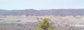
| Image:Roaring Branch Trail - View of Stone Mountains from High Butte.JPG|View of Stone Mountains from High Butte
| | |Marker Title=Overlook |
| Image:Roaring Branch Trail - wide creek crossing.JPG|Wide Creek Crossing
| | |Marker Description=[[File:High Butte.jpg|150px|High Butte Overlook into Powell Valley]] |
| <!-- Do not remove the end gallery code.-->
| | |Marker Location=36.85002, -82.83458 |
| </gallery>
| | }} |
| | | {{Map Marker |
| <!-- Finally add the trail to any Categories it should belong to. Please keep the State category. To make a new category just type [[Category:mycategory]]. Keep in mind categories are case sensitive. -->
| | |Icon Type=Water crossing |
| [[Category:Virginia]] [[Category:Waterfalls]] [[Category:Overlook]] [[Category:Hiking]] [[Category:Hard]]
| | |Marker Title=Creek Crossing |
| | |Marker Description=[[File:Roaring Branch Trail - first creek crossing.JPG|150px|First creek crossing]] |
| | |Marker Location=36.87819,-82.79517 |
| | }} |
| | {{Map Marker |
| | |Icon Type=Water crossing |
| | |Marker Title=Creek Crossing |
| | |Marker Location=36.87550,-82.80042 |
| | }} |
| | {{Map Marker |
| | |Icon Type=Water crossing |
| | |Marker Title=Creek Crossing |
| | |Marker Location=36.86806,-82.80827 |
| | }} |
| | {{Map Marker |
| | |Icon Type=Water crossing |
| | |Marker Title=Creek Crossing |
| | |Marker Location=36.86592,-82.81091 |
| | }} |
| | {{Map Marker |
| | |Icon Type=Water crossing |
| | |Marker Title=Creek Crossing |
| | |Marker Location=36.86594,-82.81046 |
| | }} |
| | {{Map Marker |
| | |Icon Type=Water crossing |
| | |Marker Title=Creek Crossing |
| | |Marker Location=36.87606,-82.79976 |
| | }} |
| Roaring Branch Trail
(log in to submit report)
|
|
|
|
| Highlight
|
Starting waterfall, view of the Powell River Valley
|
| Located
|
Big Stone Gap
|
| Trail Marking
|
Yellow
|
| Trail UseThings allowed to do on or near the trail
|

|
| FeaturesThings to see on or near the trail
|
 
|
| Difficulty Rating
|
Hard
|
| Hiking TimeTime from car and back. Includes any time hiking to access this trail.
|
7 hrs0.438 Days <br />420 Min <br /> round trip
|
| Distance:
|
3.868 mi6.225 km <br /> trailStrict non-repeating trail length / 7.736 mi12.45 km <br /> round tripTypical or shortest length from the car, hike the trail, and return to car
|
| Trail Type
|
In-and-Out
|
| Low / High Point
|
1,581 ft527 Yards <br />481.889 Meters <br /> / 3,042 ft1,014 Yards <br />927.202 Meters <br />
|
| Elev. Gain/LossSee link for details of calculation. Gain/Loss is direction dependent.
|
1,529 ft466.039 Meters <br /> / (-70 ft-21.336 Meters <br />) – East-to-West
|
| Trip ReportsFrom user "hiked it" submissions<br />Recent is within last 90 days
|
No hikes logged yet
|
| NearbyWithin 5 mi<br />Click link to view list
|
No other Trails within 5 mi
|
| Parking
|
36° 53' 1.21" N, 82° 47' 16.40" W Map
|
| Trailhead
|
36° 53' 1.21" N, 82° 47' 16.40" W Map
|
Loading map... {"type":"ROADMAP","minzoom":false,"maxzoom":false,"types":["ROADMAP","SATELLITE","HYBRID","TERRAIN"],"mappingservice":"googlemaps3","width":"100%","height":"180px","centre":false,"title":"","label":"","icon":"","lines":[],"polygons":[],"circles":[],"rectangles":[],"copycoords":false,"static":false,"visitedicon":"","wmsoverlay":false,"zoom":8,"layers":[],"controls":[""],"zoomstyle":"DEFAULT","typestyle":"DEFAULT","autoinfowindows":false,"resizable":false,"kmlrezoom":false,"poi":true,"cluster":false,"clustergridsize":60,"clustermaxzoom":20,"clusterzoomonclick":true,"clusteraveragecenter":true,"clusterminsize":2,"imageoverlays":[],"kml":[],"gkml":[],"searchmarkers":"","fullscreen":false,"scrollwheelzoom":false,"locations":[{"text":"\u003Cb\u003E\u003Cdiv class=\"mw-parser-output\"\u003E\u003Cp\u003ERoaring Branch Trail\n\u003C/p\u003E\u003C/div\u003E\u003C/b\u003E\u003Cdiv class=\"mw-parser-output\"\u003E\u003Cp\u003EMain Parking Location\n\u003C/p\u003E\u003C/div\u003E","title":"Roaring Branch Trail\n","link":"","lat":36.88367000000000217596607399173080921173095703125,"lon":-82.78789000000000442014425061643123626708984375,"icon":""}]} |
| Show In Google Maps
|
Loading map...
{"format":"googlemaps3","type":"TERRAIN","minzoom":false,"maxzoom":false,"types":["SATELLITE","HYBRID","TERRAIN"],"limit":50,"offset":0,"link":"none","sort":[""],"order":[],"headers":"show","mainlabel":"","intro":"","outro":"","searchlabel":"... further results","default":"","import-annotation":false,"width":"auto","height":"600px","centre":false,"title":"","label":"","icon":"","lines":[],"polygons":[],"circles":[],"rectangles":[],"copycoords":false,"static":false,"visitedicon":"","wmsoverlay":false,"zoom":false,"layers":[],"controls":["pan","zoom","type","scale","streetview","rotate"],"zoomstyle":"DEFAULT","typestyle":"DEFAULT","autoinfowindows":false,"resizable":false,"kmlrezoom":true,"poi":true,"cluster":false,"clustergridsize":60,"clustermaxzoom":20,"clusterzoomonclick":true,"clusteraveragecenter":true,"clusterminsize":2,"imageoverlays":[],"kml":[],"gkml":["https://tehcc.org/clubwiki/images/Roaring_Branch_Trail.kml"],"searchmarkers":"","fullscreen":false,"scrollwheelzoom":false,"showtitle":false,"hidenamespace":true,"template":"Map Balloon Template","userparam":"","activeicon":"","pagelabel":false,"ajaxcoordproperty":"","ajaxquery":"","locations":[{"text":"\u003Cp\u003E\u003Cb\u003E\u003Ca class=\"mw-selflink selflink\"\u003ERoaring Branch Trail\u003C/a\u003E\u003C/b\u003E\u003Cbr /\u003E\u003C/p\u003E\u003Chr /\u003E\u003Cp\u003E3.87\u0026#160;Mi (6.22\u0026#160;km)\u003Cbr /\u003EDifficulty: Hard\u003Cbr /\u003EMarking: Yellow\u003C/p\u003E","title":"Roaring Branch Trail","link":"","lat":36.88367000000000217596607399173080921173095703125,"lon":-82.78789000000000442014425061643123626708984375,"icon":"/clubwiki/images/MarkerT.png"},{"text":"\u003Cp\u003E\u003Cb\u003EOverlook\u003C/b\u003E\u003Cbr /\u003E\u003C/p\u003E\u003Chr /\u003E\u003Cp\u003E\u003Ca href=\"/wiki/File:High_Butte.jpg\" class=\"image\" title=\"High Butte Overlook into Powell Valley\"\u003E\u003Cimg alt=\"High Butte Overlook into Powell Valley\" src=\"/clubwiki/images/thumb/High_Butte.jpg/150px-High_Butte.jpg\" decoding=\"async\" width=\"150\" height=\"113\" srcset=\"/clubwiki/images/thumb/High_Butte.jpg/225px-High_Butte.jpg 1.5x, /clubwiki/images/thumb/High_Butte.jpg/300px-High_Butte.jpg 2x\" data-file-width=\"600\" data-file-height=\"450\" /\u003E\u003C/a\u003E\u003C/p\u003E","title":"Roaring Branch Trail","link":"","lat":36.850020000000000663931132294237613677978515625,"lon":-82.8345800000000025420376914553344249725341796875,"icon":"/clubwiki/images/MarkerE.png"},{"text":"\u003Cp\u003E\u003Cb\u003ECreek Crossing\u003C/b\u003E\u003Cbr /\u003E\u003C/p\u003E\u003Chr /\u003E\u003Cp\u003ECreek Crossing\u003C/p\u003E","title":"Roaring Branch Trail","link":"","lat":36.8680599999999998317434801720082759857177734375,"lon":-82.80826999999999316059984266757965087890625,"icon":"/clubwiki/images/MarkerJ.png"},{"text":"\u003Cp\u003E\u003Cb\u003ECreek Crossing\u003C/b\u003E\u003Cbr /\u003E\u003C/p\u003E\u003Chr /\u003E\u003Cp\u003ECreek Crossing\u003C/p\u003E","title":"Roaring Branch Trail","link":"","lat":36.87606000000000250338416662998497486114501953125,"lon":-82.7997600000000062436811276711523532867431640625,"icon":"/clubwiki/images/MarkerJ.png"},{"text":"\u003Cp\u003E\u003Cb\u003ECreek Crossing\u003C/b\u003E\u003Cbr /\u003E\u003C/p\u003E\u003Chr /\u003E\u003Cp\u003ECreek Crossing\u003C/p\u003E","title":"Roaring Branch Trail","link":"","lat":36.8659200000000026875568437390029430389404296875,"lon":-82.810910000000006903064786456525325775146484375,"icon":"/clubwiki/images/MarkerJ.png"},{"text":"\u003Cp\u003E\u003Cb\u003ECreek Crossing\u003C/b\u003E\u003Cbr /\u003E\u003C/p\u003E\u003Chr /\u003E\u003Cp\u003ECreek Crossing\u003C/p\u003E","title":"Roaring Branch Trail","link":"","lat":36.86594000000000193040250451304018497467041015625,"lon":-82.810460000000006175469025038182735443115234375,"icon":"/clubwiki/images/MarkerJ.png"},{"text":"\u003Cp\u003E\u003Cb\u003ECreek Crossing\u003C/b\u003E\u003Cbr /\u003E\u003C/p\u003E\u003Chr /\u003E\u003Cp\u003ECreek Crossing\u003C/p\u003E","title":"Roaring Branch Trail","link":"","lat":36.8755000000000023874235921539366245269775390625,"lon":-82.800420000000002573870006017386913299560546875,"icon":"/clubwiki/images/MarkerJ.png"},{"text":"\u003Cp\u003E\u003Cb\u003ECreek Crossing\u003C/b\u003E\u003Cbr /\u003E\u003C/p\u003E\u003Chr /\u003E\u003Cp\u003E\u003Ca href=\"/wiki/File:Roaring_Branch_Trail_-_first_creek_crossing.JPG\" class=\"image\" title=\"First creek crossing\"\u003E\u003Cimg alt=\"First creek crossing\" src=\"/clubwiki/images/thumb/Roaring_Branch_Trail_-_first_creek_crossing.JPG/150px-Roaring_Branch_Trail_-_first_creek_crossing.JPG\" decoding=\"async\" width=\"150\" height=\"200\" srcset=\"/clubwiki/images/thumb/Roaring_Branch_Trail_-_first_creek_crossing.JPG/225px-Roaring_Branch_Trail_-_first_creek_crossing.JPG 1.5x, /clubwiki/images/thumb/Roaring_Branch_Trail_-_first_creek_crossing.JPG/300px-Roaring_Branch_Trail_-_first_creek_crossing.JPG 2x\" data-file-width=\"1928\" data-file-height=\"2572\" /\u003E\u003C/a\u003E\u003C/p\u003E","title":"Roaring Branch Trail","link":"","lat":36.87818999999999647343429387547075748443603515625,"lon":-82.7951699999999988222043612040579319000244140625,"icon":"/clubwiki/images/MarkerJ.png"},{"text":"\u003Cp\u003E\u003Cb\u003ETrailhead\u003C/b\u003E\u003Cbr /\u003E\u003C/p\u003E\u003Chr /\u003E\u003Cp\u003E\u003Ca href=\"/wiki/File:Roaring_Branch_Trailhead.JPG\" class=\"image\" title=\"Trailhead sign with no trail name\"\u003E\u003Cimg alt=\"Trailhead sign with no trail name\" src=\"/clubwiki/images/thumb/Roaring_Branch_Trailhead.JPG/150px-Roaring_Branch_Trailhead.JPG\" decoding=\"async\" width=\"150\" height=\"270\" srcset=\"/clubwiki/images/thumb/Roaring_Branch_Trailhead.JPG/225px-Roaring_Branch_Trailhead.JPG 1.5x, /clubwiki/images/thumb/Roaring_Branch_Trailhead.JPG/300px-Roaring_Branch_Trailhead.JPG 2x\" data-file-width=\"1430\" data-file-height=\"2572\" /\u003E\u003C/a\u003E\u003C/p\u003E","title":"Roaring Branch Trail","link":"","lat":36.88367000000000217596607399173080921173095703125,"lon":-82.78789000000000442014425061643123626708984375,"icon":"/clubwiki/images/MarkerA.png"}]}
Download KML / Upload new version / KML File Page / Create Profile Chart / gpsvisualizer Map
Trail Overview[edit]
Begin at a cascading waterfall. Hike up along the creek through forest. Climb the ridge line up to a rocky overlook for the Powell River valley. All within the Stone Mountain section of Jefferson National Forest.
How to get there[edit]
From Kingsport, TN
- Take US23 up to Big Stone Gap.
- Get off at "Exit 1" at Mile Marker 33.
- At end of exit ramp, turn left (west) onto Gilley Avenue into town for couple miles.
- Turn right at traffic light onto 5th Street and drive thru town.
- Street becomes Roaring Branch Road.
- Park along road by trail sign.
Narrow parking on shoulder has a couple spaces on each side of the small bridge.
Route Description[edit]
After admiring the Roaring Branch waterfall, proceed up stone stairs created by youth conservation corps. Follow yellow blazed trail as the path continues along the stream through the forest. Multiple stream crossings - some may be very difficult after heavy rain. Proceed up ridge line to High Butte overlook. (Great spot for lunch.) Reverse direction back to trailhead.
| Mileage In
|
Roaring Branch Trail
|
Mileage Out
|
| 0.0
|
Trailhead at roadside parking. Bottom of stone stairs.
|
8.1
|
| 0.3
|
Finally, top of the stone stairs.
|
7.8
|
| 0.4
|
Large blowdown, but able to step over.
|
| 0.5
|
Stream crossing - rock hopping.
|
7.6
|
| 1.1
|
Double blaze - switchback.
|
7.1
|
| 1.4
|
Stream crossing - long jump or wade.
|
6.7
|
| 1.7
|
Stream crossing - muddy lowland.
|
6.4
|
| 1.9
|
Stream crossing - with stepping stones
|
6.2
|
| 2.5-2.7
|
Path follows alternate (overflow) stream route.
|
5.4-5.6
|
| 3.0
|
Double blaze - at bottom of ridge line. Warning: briars start appearing.
|
5.1
|
| 3.3
|
Double blaze - at top of ridge line.
|
4.8
|
| 3.5
|
Seeing valley below.
|
| 4.1
|
High Butte overlook.
|
4.1
|
Typical Conditions[edit]
*** July 2020 *** Current reports are that first 2-2.5 miles are in bad/unmaintained condition with lots of downed trees and overgrowth.
Several creek crossings. The first encountered can be made by rock hopping unless the water level is up due to heavy rain, then a nearby fallen tree might provide a bridge. Others will require figuring out where to step to not sink into soft mud. The creek crossing right in front of a campsite in the trail path required us to remove boots and wade.
The mid section, still along the creek, had not yet been cleared of several small blowdowns and rhododendron growth (could be handled by loppers and a bow saw), thus required a few detours and lots of clipping. The upper section, once emerged onto the ridgeline, changes to more open forest, but briars are then present for ankle cuts. Blueberries are found up by the overlook (in season late July-Sept).
Fees, Permits, etc.[edit]
No fees or permits required for day hiking. Managed by Clinch Ranger District (Wise, VA) Tel: 276-679-8370 (M-F 8AM-4:30PM)
After the Hike[edit]
For refreshment, there is a DQ in Big Stone Gap and a McD's at the turn for US23 heading home.
High Butte Overlook into Powell Valley
View of Stone Mountains from High Butte
Stone steps by youth conservation corps in 1970s
Another view from High Butte
Creek crossing which required wading
Yet another creek crossing
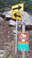
Trailhead sign with no trail name