Riverside: Difference between revisions
(add map markers) |
(tweaks using form) |
||
| Line 1: | Line 1: | ||
{{Trail | {{Trail | ||
|Banner Image= | |Banner Image=File:Roan Bridge over Doe River.jpg | ||
|Trail Highlight=Easy, handicap accessible, trail along Doe River | |||
|Park=Roan Mountain State Park | |Park=Roan Mountain State Park | ||
|Trail Marking=White | |Trail Marking=White | ||
|Trail Use=Hiking | |Trail Use=Hiking | ||
|Trail Features= | |Trail Features=Rivers | ||
|Difficulty Rating=Easy | |Difficulty Rating=Easy | ||
|Hike Time= | |Hike Time=60 min | ||
|Trail Distance= | |Trail Distance=0.5736 mi | ||
|Round Trip Distance= | |Round Trip Distance=1.18 mi | ||
|Trail Type=In-and-Out | |Trail Type=In-and-Out | ||
|High Point= | |High Point=2,914 ft | ||
|Low Point=2, | |Low Point=2,849 ft | ||
|Elevation Gain= | |Elevation Gain=0 ft | ||
|Elevation Loss= | |Elevation Loss=34 ft | ||
|Elevation Change Direction=West-to-East | |Elevation Change Direction=West-to-East | ||
|Parking location=36. | |Parking location=36.16557, -82.09624 | ||
|Trailhead location=36. | |Trailhead location=36.16547, -82.0965 | ||
}} | }} | ||
{{Trail Map|Other Trails=Fred Behrend}} | {{Trail Map|Other Trails=Fred Behrend}} | ||
| Line 41: | Line 42: | ||
== Photos == | == Photos == | ||
{{Park trail gallery|Trail={{PAGENAME}}}} | {{Park trail gallery|Trail={{PAGENAME}}}} | ||
{{Map Marker|Icon Type=Trail sign|Marker Title=Connection with Fred Behrend Trail | {{Map Marker | ||
{{Map Marker|Icon Type=Trail bridge|Marker Title=Bridge to group campsites|Marker Description=[[Image:Roan Bridge over Doe River.jpg|150px|Bridge to group campsites]]|Marker Location=36.164150,-82.098783}} | |Icon Type=Trail sign | ||
{{Map Marker|Icon Type=Trail bridge|Marker Title=Bridge to boardwalk|Marker Description=[[Image:Builders of Roan bridge.jpg|150px|Builders of the bridge]]|Marker Location=36.165727,-82.096531}} | |Marker Title=Connection with Fred Behrend Trail | ||
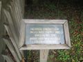
{{Map Marker|Icon Type=Point of interest|Marker Title=Handicap accessible boardwalk|Marker Description=[[Image:Roan sign about the wetlands.jpg|150px|About the wetlands]]|Marker Location=36.165566,-82.096234}} | |Marker Location=36.163128,-82.100052 | ||
{{Map Marker|Icon Type=Point of interest|Marker Title=Boardwalk ends | }} | ||
{{Map Marker|Icon Type=Point of interest|Marker Title=Trail head | {{Map Marker | ||
|Icon Type=Trail bridge | |||
|Marker Title=Bridge to group campsites | |||
|Marker Description=[[Image:Roan Bridge over Doe River.jpg|150px|Bridge to group campsites]] | |||
|Marker Location=36.164150,-82.098783 | |||
}} | |||
{{Map Marker | |||
|Icon Type=Trail bridge | |||
|Marker Title=Bridge to boardwalk | |||
|Marker Description=[[Image:Builders of Roan bridge.jpg|150px|Builders of the bridge]] | |||
|Marker Location=36.165727,-82.096531 | |||
}} | |||
{{Map Marker | |||
|Icon Type=Point of interest | |||
|Marker Title=Handicap accessible boardwalk | |||
|Marker Description=[[Image:Roan sign about the wetlands.jpg|150px|About the wetlands]] | |||
|Marker Location=36.165566,-82.096234 | |||
}} | |||
{{Map Marker | |||
|Icon Type=Point of interest | |||
|Marker Title=Boardwalk ends | |||
|Marker Location=36.165300,-82.096353 | |||
}} | |||
{{Map Marker | |||
|Icon Type=Point of interest | |||
|Marker Title=Trail head | |||
|Marker Location=36.164304,-82.096686 | |||
}} | |||
Latest revision as of 23:33, 29 December 2019
| Riverside (log in to submit report) | |
|---|---|

| |
| Highlight | Easy, handicap accessible, trail along Doe River |
| Park | Roan Mountain State Park |
| Located | Roan Mountain, TennesseeLocation inherited from associated park |
| Trail Marking | White |
| Trail UseThings allowed to do on or near the trail |
|
| FeaturesThings to see on or near the trail |
|
| Difficulty Rating | Easy |
| Hiking TimeTime from car and back. Includes any time hiking to access this trail. | 60 min1 Hours <br />0.0625 Days <br /> round trip |
| Distance: | 0.5736 mi0.923 km <br /> trailStrict non-repeating trail length / 1.18 mi1.899 km <br /> round tripTypical or shortest length from the car, hike the trail, and return to car |
| Trail Type | In-and-Out |
| Low / High Point | 2,849 ft949.667 Yards <br />868.375 Meters <br /> / 2,914 ft971.333 Yards <br />888.187 Meters <br /> |
| Elev. Gain/LossSee link for details of calculation. Gain/Loss is direction dependent. | 0 ft0 Meters <br /> / (34 ft10.363 Meters <br />) – West-to-East |
| Trip ReportsFrom user "hiked it" submissions<br />Recent is within last 90 days | No hikes logged yet |
| NearbyWithin 5 mi<br />Click link to view list | 12 trails / 50.1 mi of trail |
| Parking | 36° 9' 56.05" N, 82° 5' 46.46" W Map |
| Trailhead | 36° 9' 55.69" N, 82° 5' 47.40" W Map |
|
| |
| Show In Google Maps | |
Download KML / Upload new version / KML File Page / Create Profile Chart / gpsvisualizer Map
Trail Overview[edit]
One of the flattest and easiest trail within the Roan Mountain State Park trail system. A portion of this trail is handicap friendly including an accessible bridge from the shelter to the boardwalk through a portion of wetlands. It can also be used to connect between the park cabins and group camping or the regular campground.
How to get there[edit]
Leaving south on 143, the most direct access is at the shelter before the cabins. This access is mid-way through the trail.
Route Description[edit]

Beginning at a park shelter, this trail begins with either crossing the river for a short hike, or walking along the river until it meets Fred Behrend Trail.
Accessible from this trail is the Fred Behrend Trail.
Typical Conditions[edit]
Being a TN state park, the dirt and gravel trails are kept in good condition. Some of the trail sections are steep, thus can be slippery after a rain.
Photos[edit]
Builders of the bridge

Trail Profile
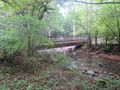
Bridge over Doe River
Boardwalk sign

