Ridge Crest Trail: Difference between revisions
(Creating trail page in anticipation of creating kml next weekend) |
No edit summary |
||
| Line 38: | Line 38: | ||
==Miscellaneous Information== | ==Miscellaneous Information== | ||
Restroom, picnic tables at Smallman Area. | |||
==Gallery== | ==Gallery== | ||
{{Park trail gallery|Trail={{PAGENAME}}}} | {{Park trail gallery|Trail={{PAGENAME}}}} | ||
Revision as of 21:11, 30 August 2020
| Ridge Crest Trail (log in to submit report) | |
|---|---|

| |
| Highlight | Steep descent to Cherokee Lake |
| Park | Panther Creek State Park |
| Located | Morristown, TennesseeLocation inherited from associated park |
| Trail Marking | White |
| Trail UseThings allowed to do on or near the trail |
|
| FeaturesThings to see on or near the trail |
|
| Difficulty Rating | Hard |
| Hiking TimeTime from car and back. Includes any time hiking to access this trail. | 45 min0.75 Hours <br />0.0469 Days <br /> round trip |
| Distance: | 0.70 mi1.127 km <br /> trailStrict non-repeating trail length / 1.41.4 mi <br />2.253 km <br /> round tripTypical or shortest length from the car, hike the trail, and return to car |
| Trail Type | In-and-Out |
| Low / High Point | 1073 ft357.667 Yards <br />327.05 Meters <br /> / 1375 ft458.333 Yards <br />419.1 Meters <br /> |
| Elev. Gain/LossSee link for details of calculation. Gain/Loss is direction dependent. | 400 ft121.92 Meters <br /> / (400 ft121.92 Meters <br />) – West-to-East |
| Trip ReportsFrom user "hiked it" submissions<br />Recent is within last 90 days | 1 logged hikes (0 recent) |
| NearbyWithin 5 mi<br />Click link to view list | 9 trails / 12.7 mi of trail |
| Parking | 36° 12' 39.06" N, 83° 25' 19.45" W Map |
| Trailhead | 36° 12' 40.68" N, 83° 25' 17.90" W Map |
|
| |
| Show In Google Maps | |
Download KML / Upload new version / KML File Page / Create Profile Chart / gpsvisualizer Map
Trail Overview
Descend on rocky path from Smallman Area parking on highpoint to Cherokee Lake - and back up!
How To Get There
Once at the state park, stay on Panther Creek Park Road to the parking lot near very end. Trailhead just to the west of the "heart" turnaround.
Route Description
More later, but down, view lake, and back up. For TEHCC, this trail would be rated easy due to short length and limited elevation change. But for general public, it is difficult due to rocky tread with most of the elevation change in two drops.
At bottom, but the lake, intersects Hunt Knob horse trail.
Typical Conditions
Rocky! Some comments about poor trail marking.
Miscellaneous Information
Restroom, picnic tables at Smallman Area.
Gallery
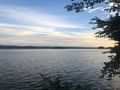
Cherokee Lake at sunrise
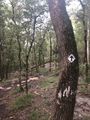
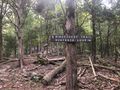
Hiking Trail Marker

Down to the lake, and back up
Shore view from lake
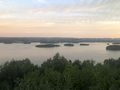
Smallman Area Overlook
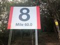
Trail intersection


