Panther Creek State Park
| Panther Creek State Park | |
|---|---|

| |
| Park Type | State Park |
| Located | Morristown, Tennessee |
| External Links | Official Website |
| Entrance Fee | Unknown |
| ActivitiesThings to do at the park | |
| Park AmenitiesThings built to enjoy or use at the park | |
| FeaturesNatural things to see at the park | |
| Park Trails |
16 Trails / Total of 25.65 miles41.28 km <br /> |
| Lodging Types | |
| Camping Amenities |
|
| Park Area | 1,435 acres5.807 km² <br /> |
| Operated By | Tennessee Department of Environment and Conservation |
| Main Location | 36° 12' 23.76" N, 83° 24' 23.40" W Map |
|
| |
| Show In Google Maps | |
Download KML / Upload new version / KML File Page
Park Overview[edit]
Panther Creek State Park is located on the Cherokee Reservoir north of Morristown, Tennessee. Available activities include hiking, mountain biking, camping, fishing, boating, horseback riding, and swimming.
How to get there[edit]
From Kingsport, TN:
- Take I-81 South to Exit 12 (Lowland/Morristown).
- At bottom of exit ramp, turn right (north) onto Enka Highway TN-160, and drive for 11.3 miles.
- Turn right (east) onto Andrew Johnson Highway US-11E.
- Travel 1.2 miles and turn left (north) onto Panther Creek Road.
- Park entrance will be reached in 1.6 miles.
Trailheads are at several points in the park.
Trails[edit]
The following trails are available:
| Park Trails | Distance | Difficulty | Marking | Usage | Highlight |
|---|---|---|---|---|---|
| Lost Road Trail | 1.90 mi | Hard | Black arrow on silver diamond |
|
Rightly named trail is hard to follow for its full distance |
| Maple Arch Trail | 3.20 mi | Medium | Black arrow on yellow diamond |
|
Path along Cherokee Lake and then further up hillside |
| Norris Blackburn Trail | 0.45 mi | Easy | Black arrow on silver diamond |
|
Thru maple forest to a wildlife observatory |
| Old Wagon Trail | 1.00 mi | Easy | Black arrow on red diamond |
|
Good for beginners |
| Ore Mine Trail | 1.70 mi | Medium | Black arrow on silver diamond |
|
Loop around Ore Mine Hill |
| Point Lookout Trail | 1.90 mi | Medium | Black arrow on silver diamond |
|
Look out over Cherokee Lake or also walk down to the water |
| Ridge Crest Trail | 0.70 mi | Medium | Black arrow on silver diamond |
|
Steep descent to Cherokee Lake |
| Road to Recycling Trail | 1.20 mi | Easy | Black arrow on silver diamond |
|
Good for trail running |
| Seven Sinkholes Trail | 0.60 mi | Easy | Black arrow on silver diamond |
|
Wander around more than seven sinkholes |
| Deer Run TrailThis trail is a "stub" either because of its short length, lack of significance, or the page hasn't been created yet. The page can be created, but then delete the stub reference from this park. | 0.80 mi | Medium | Red | ||
| Hunt Knob TrailThis trail is a "stub" either because of its short length, lack of significance, or the page hasn't been created yet. The page can be created, but then delete the stub reference from this park. | 3.80 mi | Medium | Yellow | Follows edge of Cherokee Lake up to ridge | |
| Old Farm TrailsThis trail is a "stub" either because of its short length, lack of significance, or the page hasn't been created yet. The page can be created, but then delete the stub reference from this park. | 2.50 mi | Easy | Red | for both loops | |
| Panther Path TrailThis trail is a "stub" either because of its short length, lack of significance, or the page hasn't been created yet. The page can be created, but then delete the stub reference from this park. | 0.90 mi | Easy | Red | Good for beginners. | |
| Piney Cove TrailThis trail is a "stub" either because of its short length, lack of significance, or the page hasn't been created yet. The page can be created, but then delete the stub reference from this park. | 0.60 mi | Medium | Red | ||
| Pioneer TrailThis trail is a "stub" either because of its short length, lack of significance, or the page hasn't been created yet. The page can be created, but then delete the stub reference from this park. | 2.40 mi | Medium | Red | ||
| Trout Lily TrailThis trail is a "stub" either because of its short length, lack of significance, or the page hasn't been created yet. The page can be created, but then delete the stub reference from this park. | 2.00 mi | Medium | Red | for experienced bicyclists |
Get a paper park map from box at the welcome center! Cell service in the park is one-bar at best, so don't rely on electronic maps. The park trails are a network of short segments, so the avid hiker will join several together for a longer hike. They are primarily classified as being for hiking, biking, or horses with basic colored arrow blazes of silver, red, and yellow respectively. Parking is only allowed in the designated parking lots and not necessarily at the trailheads.
Fees, Hours, Restrictions[edit]
The park is open 6AM to sunset year around. There is no entrance fee. Welcome center hours are 8AM-6PM, although the bathrooms are available anytime. Dogs are allowed on leash.
One learning obtained from the park's trail manager is trail maintenance primary occurs during the winter months when the grounds crew is not occupied mowing the open spaces and keeping up with the pool. The East TN Backcountry Horsemen also work on the horse trails.
Gallery[edit]
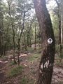
Hiking Trail Marker

Main entrance sign
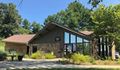
Welcome Center

