Rhododendron Gardens: Difference between revisions
(Update IB to new format) |
(Adding new IB park field and no kml category) |
||
| Line 2: | Line 2: | ||
{{Infobox Trail | {{Infobox Trail | ||
| Image Name = Rhododendron Gardens - rhodo field view.JPG | | Image Name = Rhododendron Gardens - rhodo field view.JPG | ||
| Park = Roan Mountain State Park | |||
| City = Roan Mountain | | City = Roan Mountain | ||
| State = Tennessee | | State = Tennessee | ||
| Line 65: | Line 66: | ||
<!-- Finally add the trail to any Categories it should belong to. Please keep the State category. To make a new category just type [[Category:mycategory]]. Keep in mind categories are case sensitive. --> | <!-- Finally add the trail to any Categories it should belong to. Please keep the State category. To make a new category just type [[Category:mycategory]]. Keep in mind categories are case sensitive. --> | ||
[[Category:Tennessee]][[Category:Easy]] | [[Category:Tennessee]][[Category:Easy]][[Category:No Trail KML]] | ||
Revision as of 21:28, 29 August 2015
| |||||||||||||||||||||||||||||||||||||||
Trail Overview
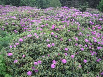
Views and extensive natural Rhododendron Gardens (late for blossoms), views, spruce fir forest
How to get there
From Elizabethton, TN
- Turn on to US 19E and US 321 for about 6 miles through spectacular gorge of Doe River to Hampton, TN to intersection where US 19E and US 321 diverge.
- Continue straight on US 19E about 13 miles to Roan Mountain, TN at TN 143.
- Turn right in Roan Mountain, Tenn. on TN 143 and drive 14 miles to Carvers Gap at the North Carolina State Line.
- Turn right onto USFS road and drive 2 miles to parking lot at Rhododendron Gardens (fee) and Trailhead.
- Park in paved parking lot or further along gravel road at gardens.
Route Description
Hikers continue along crest of mountain on trail and/or down through gardens on paved walkways. Trails are handicapped accessible. There are several trails through the rhododendron gardens. A linear trail extends from the paved parking lot south along the crest of the mountain through other parking lots and beyond to Roan High Bluff, where there is an overlook. Also, a series of short loop hikes extends down on the North Carolina side from a USFS booth at the first unpaved parking area. Information is available at the booth. The booth is visible from the linear trail. Some of these trails are paved and handicapped accessible and there is a wooden boardwalk overlook as well. Picnic tables are available near the parking area.
Typical Conditions
Fees, Permits, etc.
Access to the Rhododendron Gardens is limited to mid-May through September with a $3 entrance fee per car.
