Rattlesnake Ridge: Difference between revisions
(initial page creation) |
(associate with RCF RA) |
||
| (30 intermediate revisions by 4 users not shown) | |||
| Line 1: | Line 1: | ||
{{Trail | |||
{{ | |Banner Image=File:View from Rattlesnake Ridge.JPG | ||
|Trail Number=USFS #26 | |||
|Park=Rock Creek Recreation Area | |||
|City=Erwin | |||
|Land Owner=Cherokee National Forest | |||
|Trail Marking=None | |||
|Trail Use=Hiking, Camping, Hunting | |||
|Trail Features=Vistas, Mountains | |||
|Difficulty Rating=Hard | |||
|Hike Time=6 hrs | |||
|Trail Distance=3.524 mi | |||
|Round Trip Distance=7.048 mi | |||
|Trail Type=In-and-Out | |||
|High Point=4,855 Ft | |||
|Low Point=2,424 ft | |||
|Elevation Gain=2,431 Ft | |||
36. | |Elevation Loss=0 Ft | ||
|Elevation Change Direction=West-to-East | |||
|Parking location=36.13821, -82.35028 | |||
|Trailhead location=36.13999, -82.34217 | |||
}} | }} | ||
{{Trail Map}} | |||
__TOC__ | |||
== Trail Overview == | == Trail Overview == | ||
<!-- Enter a overview of the trail. What attracts you to this trail, points of interest, types of flowers, lakes, and peaks that you see along the way. --> | <!-- Enter a overview of the trail. What attracts you to this trail, points of interest, types of flowers, lakes, and peaks that you see along the way. --> | ||
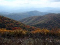
Located in | Located in Cherokee National Forest, a steep hike to outstanding views of the mountains. | ||
== How to get there == | == How to get there == | ||
<!-- Please enter detailed instruction on how to find the trail head. --> | <!-- Please enter detailed instruction on how to find the trail head. --> | ||
From the | From Erwin, TN | ||
#Take Exit 36 off I-26. | |||
#Turn left on unnamed road across the interstate to intersection with Tenn. 107 in Erwin. | |||
#Turn right on Tenn. 107 for about a mile. | |||
#Turn left on Tenn. 395 (USFS sign to Beauty Spot). | |||
#Proceed 3.2 miles. | |||
#Turn left into the USFS Rock Creek Recreation Area. | |||
#Park near restrooms at Picnic Area. | |||
Same as for [[Rock Creek Falls]] trail | |||
== Route Description== | == Route Description== | ||
<!-- Detailed description of the route. Is there any side trails that are worth traveling? --> | <!-- Detailed description of the route. Is there any side trails that are worth traveling? --> | ||
Rattlesnake Ridge is USFS #26 Trail. Out-and-back hike starting at Rock Creek Recreation Area parking lot. Proceed to the back of the campground area (behind the tent camping section) to the trailhead common with [[Rock Creek Falls]]. Cross the footbridge to the left. Take the split along an old road for about a mile over to Dick Creek Gap - a junction of several trails and old roads. Head up the ridgeline into the Unaka Mountain Wilderness (sign seen after 100 yards) to the top at the Pleasant Gardens Overlook on Unaka Mountain. When you see spruce trees, you are near the top where all the highest mountains in Unicoi County are visible. | |||
== Typical Conditions == | == Typical Conditions == | ||
<!-- Typical conditions throughout the year of what to expect on the trail. Rocky, muddy, sandy, flowers, lots of downed trees? --> | <!-- Typical conditions throughout the year of what to expect on the trail. Rocky, muddy, sandy, flowers, lots of downed trees? --> | ||
Being in wilderness-designated area and not heavily used, the trail may be a little overgrown but is well defined. | |||
==Fees, Permits, etc. == | |||
<!-- Please list any Fees, Permits, Regulations, etc. that may be required on this trail.--> | |||
Rock Creek Campground is open May through November (check USFS website below for exact dates). Campground gates are closed from 10 PM until 7 AM. If closed, then add a mile to hike in from the main gate. Day use area fee is $2 per car. Permit must be visibly displayed in vehicle. Wilderness designated area, thus group size is limited to 14 people. | |||
For more information, see [[https://www.fs.usda.gov/recarea/cherokee/recarea/?recid=34978 Forest Service webpage]]. | |||
== Misc. Information == | == Misc. Information == | ||
<!-- Enter any additional information that doesn't fit an any other fields. Any seasonal features, factoids, etc...? --> | <!-- Enter any additional information that doesn't fit an any other fields. Any seasonal features, factoids, etc...? --> | ||
The Pleasant Gardens Overlook on Unaka Mountain is called that due to the large number of laurels in area. Beauty Spot can be seen in the distance. The overlook can be reached by forest service roads, but the last section is extremely rocky. (Busted the radiator on a sedan, so high clearance vehicle recommended.) | |||
Dogs are allowed, but must remain on a 6 ft or shorter leash. | |||
== Photos == | == Photos == | ||
{{Park trail gallery|Trail={{PAGENAME}}}} | |||
{{Map Marker | |||
|Icon Type=Point of interest | |||
|Marker Title=Pleasant Gardens Overlook | |||
|Marker Location=36.13425, -82.31113 | |||
}} | |||
Latest revision as of 11:12, 19 September 2021
| Rattlesnake Ridge (log in to submit report) | |
|---|---|

| |
| Trail Number | USFS #26 |
| Park | Rock Creek Recreation Area |
| Land Owner | Cherokee National Forest |
| Located | Erwin, Tennessee |
| Trail Marking | None |
| Trail UseThings allowed to do on or near the trail |
|
| FeaturesThings to see on or near the trail |
|
| Difficulty Rating | Hard |
| Hiking TimeTime from car and back. Includes any time hiking to access this trail. | 6 hrs0.375 Days <br />360 Min <br /> round trip |
| Distance: | 3.524 mi5.671 km <br /> trailStrict non-repeating trail length / 7.048 mi11.343 km <br /> round tripTypical or shortest length from the car, hike the trail, and return to car |
| Trail Type | In-and-Out |
| Low / High Point | 2,424 ft808 Yards <br />738.835 Meters <br /> / 4,855 Ft1,618.333 Yards <br />1,479.804 Meters <br /> |
| Elev. Gain/LossSee link for details of calculation. Gain/Loss is direction dependent. | 2,431 Ft740.969 Meters <br /> / (0 Ft0 Meters <br />) – West-to-East |
| Trip ReportsFrom user "hiked it" submissions<br />Recent is within last 90 days | 1 logged hikes (0 recent) |
| NearbyWithin 5 mi<br />Click link to view list | 2 trails / 13.3 mi of trail |
| Parking | 36° 8' 17.56" N, 82° 21' 1.01" W Map |
| Trailhead | 36° 8' 23.96" N, 82° 20' 31.81" W Map |
|
| |
| Show In Google Maps | |
Download KML / Upload new version / KML File Page / Create Profile Chart / gpsvisualizer Map
Trail Overview[edit]
Located in Cherokee National Forest, a steep hike to outstanding views of the mountains.
How to get there[edit]
From Erwin, TN
- Take Exit 36 off I-26.
- Turn left on unnamed road across the interstate to intersection with Tenn. 107 in Erwin.
- Turn right on Tenn. 107 for about a mile.
- Turn left on Tenn. 395 (USFS sign to Beauty Spot).
- Proceed 3.2 miles.
- Turn left into the USFS Rock Creek Recreation Area.
- Park near restrooms at Picnic Area.
Same as for Rock Creek Falls trail
Route Description[edit]
Rattlesnake Ridge is USFS #26 Trail. Out-and-back hike starting at Rock Creek Recreation Area parking lot. Proceed to the back of the campground area (behind the tent camping section) to the trailhead common with Rock Creek Falls. Cross the footbridge to the left. Take the split along an old road for about a mile over to Dick Creek Gap - a junction of several trails and old roads. Head up the ridgeline into the Unaka Mountain Wilderness (sign seen after 100 yards) to the top at the Pleasant Gardens Overlook on Unaka Mountain. When you see spruce trees, you are near the top where all the highest mountains in Unicoi County are visible.
Typical Conditions[edit]
Being in wilderness-designated area and not heavily used, the trail may be a little overgrown but is well defined.
Fees, Permits, etc.[edit]
Rock Creek Campground is open May through November (check USFS website below for exact dates). Campground gates are closed from 10 PM until 7 AM. If closed, then add a mile to hike in from the main gate. Day use area fee is $2 per car. Permit must be visibly displayed in vehicle. Wilderness designated area, thus group size is limited to 14 people.
For more information, see [Forest Service webpage].
Misc. Information[edit]
The Pleasant Gardens Overlook on Unaka Mountain is called that due to the large number of laurels in area. Beauty Spot can be seen in the distance. The overlook can be reached by forest service roads, but the last section is extremely rocky. (Busted the radiator on a sedan, so high clearance vehicle recommended.)
Dogs are allowed, but must remain on a 6 ft or shorter leash.
Photos[edit]
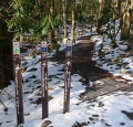
Trailhead with Rock Creek Falls - Photo by Dennis Mott (Feb 2010)