Point Lookout Trail: Difference between revisions
(Updated pins) |
(Adding info from GE) |
||
| Line 8: | Line 8: | ||
|Hike Time=90 minutes | |Hike Time=90 minutes | ||
|Trail Distance=1.90 mi | |Trail Distance=1.90 mi | ||
|Round Trip Distance= | |Round Trip Distance=2.8 mi | ||
|Trail Type=Loop | |Trail Type=Loop | ||
|High Point= | |High Point=1428 ft | ||
|Low Point=1073 ft at lake | |Low Point=1073 ft at lake | ||
|Elevation Gain=785 ft | |||
|Elevation Loss=794 ft | |||
|Elevation Change Direction=Clockwise | |Elevation Change Direction=Clockwise | ||
|Parking location=36.21301, -83.41643 | |Parking location=36.21301, -83.41643 | ||
| Line 37: | Line 39: | ||
! Mileage !! Feature !! Elevation | ! Mileage !! Feature !! Elevation | ||
|- | |- | ||
| (0.10) || Parking || | | (0.10) || Parking || 1325 | ||
|- | |- | ||
| 0.00 || Trailhead || | | 0.00 || Trailhead || 1293 | ||
|- | |- | ||
| 0. | | 0.03 || Trail split to straight or right || 1283 | ||
|- | |- | ||
| | | 0.25 || Overlook with bench || 1350 | ||
|- | |- | ||
| | | 1.10 || Spur trail to Cherokee Lake || 1225 | ||
|- | |- | ||
| | | 1.60 || At Cherokee Lake || 1073 | ||
|- | |- | ||
| | | 2.10 || North intersection with Horse Trail || 1170 | ||
|- | |- | ||
| | | 2.35 || South intersection with Horse Trail || 1095 | ||
|- | |||
| 2.70 || Back at trailhead || 1295 | |||
|- | |||
| 2.80 || Back at parking || 1325 | |||
|} | |} | ||
Revision as of 16:58, 11 September 2020
| Point Lookout Trail (log in to submit report) | |
|---|---|

| |
| Highlight | Take partway for 400' overlook or hike down to the lake |
| Park | Panther Creek State Park |
| Located | Morristown, TennesseeLocation inherited from associated park |
| Trail Marking | Black arrow on silver diamond |
| Trail UseThings allowed to do on or near the trail |
|
| FeaturesThings to see on or near the trail |
|
| Difficulty Rating | Medium |
| Hiking TimeTime from car and back. Includes any time hiking to access this trail. | 90 minutes1.5 Hours <br />0.0938 Days <br /> round trip |
| Distance: | 1.90 mi3.058 km <br /> trailStrict non-repeating trail length / 2.8 mi4.506 km <br /> round tripTypical or shortest length from the car, hike the trail, and return to car |
| Trail Type | Loop |
| Low / High Point | 1073 ft at lake"ftatlake" is not declared as a valid unit of measurement for this property. / 1428 ft476 Yards <br />435.254 Meters <br /> |
| Elev. Gain/LossSee link for details of calculation. Gain/Loss is direction dependent. | 785 ft239.268 Meters <br /> / (794 ft242.011 Meters <br />) – Clockwise |
| Trip ReportsFrom user "hiked it" submissions<br />Recent is within last 90 days | 1 logged hikes (0 recent) |
| NearbyWithin 5 mi<br />Click link to view list | 8 trails / 10.8 mi of trail |
| Parking | 36° 12' 46.84" N, 83° 24' 59.15" W Map |
| Trailhead | 36° 12' 49.46" N, 83° 24' 53.86" W Map |
|
| |
| Show In Google Maps | |
Download KML / Upload new version / KML File Page / Create Profile Chart / gpsvisualizer Map
Trail Overview
Look out over Cherokee Lake or also walk down to the water
How To Get There
After arriving at park entrance, continue on Panther Creek Park Road past visitors center and campground to Smallman Area parking lot. Backtrack down roadway to trailhead.
Route Description
Your choice on how far to hike - 1, 2, or 3 miles. (1) Go out to the overlook and straight back. (2) Make a loop including quarter mile of gravel horse trail. (3) During the loop hike, also walk down to the lake and back up.
Take a look at your legs. If the left one is slightly longer, then proceed clockwise around the loop as the trail path is sloped. Go counterclockwise, if you feel your right leg is longer.
For the hiking club, this trail is medium difficulty due to short length and limited elevation change but modified in this range for the strength of your knees. However, for general public, it is rated as moderately difficult in the park trail map brochure because of the overall length had having to climb back up if visiting the lake.
| Mileage | Feature | Elevation |
|---|---|---|
| (0.10) | Parking | 1325 |
| 0.00 | Trailhead | 1293 |
| 0.03 | Trail split to straight or right | 1283 |
| 0.25 | Overlook with bench | 1350 |
| 1.10 | Spur trail to Cherokee Lake | 1225 |
| 1.60 | At Cherokee Lake | 1073 |
| 2.10 | North intersection with Horse Trail | 1170 |
| 2.35 | South intersection with Horse Trail | 1095 |
| 2.70 | Back at trailhead | 1295 |
| 2.80 | Back at parking | 1325 |
Notes: - If you take the spur trail to the lake, you have committed to hiking back up the hill. - The horse trail section is a wide gravel roadbed with some erosion problems. - Return leg to trailhead is marked by a small sign in the corner of the grassy open area.
Typical Conditions
Hard packed dirt. Some slick spots after a good rain. Recommend good shoes and walking stick/trekking poles. Actual trail path appears to depend on where the blowdowns fall as the public just reroutes around.
Miscellaneous Information
Gallery
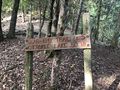
It's steep downhill to lake from here
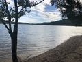
Cherokee Lake beach
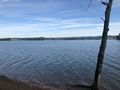
Looking across Cherokee Lake
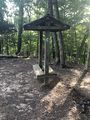
bench near overlook
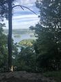
Overlook view
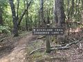
Spur trail to lake

Elevation Profile


