Pinnacle Mountain Fire Tower: Difference between revisions
(→Fees, Permits, etc.: Added ranger district info) |
(→Misc. Information: Added info and link to ATV trail) |
||
| Line 57: | Line 57: | ||
The summit is the highpoint of... Washington County (not Unicoi), Tennessee as it is just inside the county line. Pinnacle Mountain Tower was built by the Civil Conservation Corps and was in service until 1989. The trail was created and the 40 ft observation platform restored for $100,000 as a joint partnership. See [[http://www.knoxnews.com/news/2007/nov/05/historic-fire-tower-may-be-restored-with-new/ news article]] and [[http://www.fs.usda.gov/Internet/FSE_DOCUMENTS/fsbdev3_036104.pdf FS press release]]. | The summit is the highpoint of... Washington County (not Unicoi), Tennessee as it is just inside the county line. Pinnacle Mountain Tower was built by the Civil Conservation Corps and was in service until 1989. The trail was created and the 40 ft observation platform restored for $100,000 as a joint partnership. See [[http://www.knoxnews.com/news/2007/nov/05/historic-fire-tower-may-be-restored-with-new/ news article]] and [[http://www.fs.usda.gov/Internet/FSE_DOCUMENTS/fsbdev3_036104.pdf FS press release]]. | ||
The fire tower can also be accessed via a forest road off of Dry Creek Road. | The fire tower can also be accessed via a forest service road or the ATV trail [http://www.fs.usda.gov/wps/portal/fsinternet/!ut/p/c5/04_SB8K8xLLM9MSSzPy8xBz9CP0os3gDfxMDT8MwRydLA1cj72BTSw8jAwgAykeaxcN4jhYG_h4eYX5hPgYwefy6w0H24dcPNgEHcDTQ9_PIz03VL8iNMMgycVQEAIzTHkw!/dl3/d3/L2dJQSEvUUt3QS9ZQnZ3LzZfME80MEkxVkFCOTBFMktTNUJIMjAwMDAwMDA!/?ss=110804&ttype=recarea&recid=34966&actid=93&navtype=BROWSEBYSUBJECT&position=BROWSEBYSUBJECT&navid=110350000000000&pnavid=110000000000000&cid=null&pname=Cherokee+National+Forest+-+Buffalo+Mountain+ATV+Trail (FTR #29)] off of Dry Creek Road. | ||
== Maps == | == Maps == | ||
Revision as of 05:36, 12 October 2011
| |||||||||||||||||||||||||||||||||||||

Trail Overview
Great views in all directions from observation platform constructed on the old fire tower steel.
How to get there
From Kingsport or Johnson City:
- Head south on I-26
- Take Exit 32.
- At bottom of ramp, take a right.
- At the roadway tee, there is a new gravel parking lot for 3-4 vehicles with a nearby sign announcing future location for the arts center.
- Hike through gate along new gravel road into the picnic area.
- Trailhead is at the back - look for brown FS marker. Does not have the trail name on it. Parking here for only 1-2 vehicles.
Route Description
The trailhead is located at the future site of the Tanasi Arts & Heritage Center next to Interstate 26 at Exit 32. The lime green-blazed trail winds up to the top with a reasonable slope using many switchbacks - except for a ~50 yard section (steep coming down). (Unfortunately, bikers have already started to make "shortcut" damage to the trail path.) The trail crosses a gravel road near the top which also leads to the tower, but is steeper than the trail.
Reported 2.5 hours to hike up to the tower with plenty of breaks to look around, and then 1.5 hours back down.
Typical Conditions
The new trail is wide and well graded all the way to the ridge line. The trail needs this fall's leaf litter to start protecting the tread, which could be somewhat slick after rain due to being so new.
Fees, Permits, etc.
No fees or permits. Horse or motor bike riding not allowed per forest service sign. Uncertain if and when the gate is locked.
The trail is located in the Watauga Ranger District of the Cherokee National Forest. Telephone: (423) 735-1500
Misc. Information
The summit is the highpoint of... Washington County (not Unicoi), Tennessee as it is just inside the county line. Pinnacle Mountain Tower was built by the Civil Conservation Corps and was in service until 1989. The trail was created and the 40 ft observation platform restored for $100,000 as a joint partnership. See [news article] and [FS press release].
The fire tower can also be accessed via a forest service road or the ATV trail (FTR #29) off of Dry Creek Road.
Maps
<googlemap version="0.9" lat="36.2131" lon="-82.361" type="terrain" zoom="15" width="725" scale="yes" icons="http://tehcc.org/clubwiki/kml/marker{label}.png"> http://tehcc.org/clubwiki/kml/Pinnacle Mountain Fire Tower.kml
(G) 36.209268,-82.355133
Trailhead in picnic area for future arts center
 (G) 36.217133,-82.370338,Pinnacle Mountain Fire Tower
</googlemap>
(G) 36.217133,-82.370338,Pinnacle Mountain Fire Tower
</googlemap>
Photos
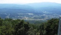
View east towards trailhead
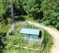
Looking down at radio tower shack
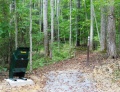
Trailhead in new picnic area

Tanasi Art Center sign near trailhead


