|
|
| (8 intermediate revisions by the same user not shown) |
| Line 1: |
Line 1: |
| <!-- The following few lines create the "Infobox" table template. Please scroll down to edit the main content of the article. -->
| | {{Trail |
| {{Infobox Trail | | |Banner Image=File:Roan Peg Leg mine entrance.jpg |
| | Image Name = Placeholder.gif
| | |Trail Highlight=View the entrance to an abandoned mine |
| | Park = Roan Mountain State Park
| | |Park=Roan Mountain State Park |
| | City = Roan Mountain
| | |Trail Marking=White |
| | State = Tennessee
| | |Trail Use=Hiking |
| | Marking = White
| | |Trail Features=Caves |
| | Trail Use = {{Dogs}} {{Fishing}} {{Hike}}
| | |Difficulty Rating=Easy |
| | Difficulty Rating = Easy
| | |Hike Time=20 min |
| | Hike Time = 20 Min
| | |Trail Distance=0.2834 mi |
| | Round Trip Distance = 3,252 Ft
| | |Round Trip Distance=0.56 mi |
| | Trail Distance = 1,626 Ft
| | |Trail Type=In-and-Out |
| | Trail Type = In-and-Out
| | |High Point=2,826 ft |
| | Elevation Gain = 337 Ft
| | |Low Point=2,670 ft |
| | Elevation Loss = -337 Ft
| | |Elevation Gain=152 ft |
| | High Point = 2,928 Ft
| | |Elevation Loss=0 ft |
| | Parking coords = 36.176541,-82.079402
| | |Elevation Change Direction=West-to-East |
| | Trailhead coords = 36.176330,-82.079002
| | |Parking location=36.17645, -82.07942 |
| | Medical = Elizabethton, TN
| | |Trailhead location=36.17633, -82.079 |
| }} | | }} |
| <!-- End Infobox template table-->
| | {{Trail Map}} |
|
| |
|
| <!-- Start of Main Page -->
| | __TOC__ |
|
| |
|
| == Trail Overview == | | == Trail Overview == |
| <!-- Enter a overview of the trail. What attracts you to this trail, points of interest, types of flowers, lakes, and peaks that you see along the way. -->
| |
| This is part of the [[Roan Mountain State Park]] trail system | | This is part of the [[Roan Mountain State Park]] trail system |
|
| |
|
| == How to get there == | | == How to get there == |
| <!-- Please enter detailed instruction on how to find the trail head. --> | | <!-- Please enter detailed instruction on how to find the trail head. --> |
| From the visitor center walk between the water wheel building and the bathrooms. Head left and go under the penstock to begin the hike. | | From the visitor center walk between the water wheel building and the bathrooms. Head left and go under the waterwheel flume to begin the hike. |
|
| |
|
| == Route Description== | | == Route Description== |
| <!-- Detailed description of the route. Is there any side trails that are worth traveling? -->
| | [[File:Peg leg mine profile.png|thumb|right]] |
| Short trail beginning at the visitor center. | | Short trail beginning at the visitor center. |
| | |
| | {| class="wikitable" border="1" |
| | |- |
| | !Feet Out |
| | !{{PAGENAME}} |
| | !Feet Back |
| | !Elevation (ft) |
| | |- |
| | |0 |
| | |Trail head at Visitor's Center |
| | |1,596 |
| | |2,714 |
| | |- |
| | |198 |
| | |Unknown split, continue right for trail |
| | |1,398 |
| | |2,697 |
| | |- |
| | |1,015 |
| | |Viewing platform |
| | |581 |
| | |2,850 |
| | |- |
| | |1,596 |
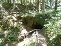
| | |Peg Leg Mine |
| | |0 |
| | |2,909 |
| | |} |
|
| |
|
| == Typical Conditions == | | == Typical Conditions == |
| Line 41: |
Line 68: |
| == Misc. Information == | | == Misc. Information == |
| <!-- Enter any additional information that doesn't fit an any other fields. Any seasonal features, factoids, etc...? --> | | <!-- Enter any additional information that doesn't fit an any other fields. Any seasonal features, factoids, etc...? --> |
| | | General John T. Wilder purchased this land as part of a 7,000 acre purchase for $25.15 an acre in 1870. One of the mines he started became known as the Peg Leg Mine. The mine was mined for iron ore. The ore was sent to a smelter across the Doe River. The water wheel, similar to the one near the visitor's center, was used to lift and drop a 500-lb hammer and to crush the ore. The ore would then be loaded on to rail cars and sent to Cranberry, North Carolina for further processing before making its way to Ohio and Pennsylvania to a steel mill. |
| == Maps ==
| |
| <!-- You can place pictures, PDF's, links, or even create a Google map with your waypoints and place it here. -->
| |
| <display_map center="36.176544,-82.077725" type="terrain" zoom="16" width="auto" height="550" gkml="http://tehcc.org/clubwiki/kml/RMSP_Peg_Leg_Trail.kml">
| |
| </display_map>
| |
|
| |
|
| == Photos == | | == Photos == |
| <gallery>
| | {{Park trail gallery|Trail={{PAGENAME}}}} |
| <!-- Place any pictures from this trail below. Ideally we would have a picture of the trailhead to help people know when they found it -->
| | {{Map Marker |
| <!-- Add a picture by typing Image:imagename.extension -->
| | |Icon Type=Parking |
| Image:placeholder.jpg|caption | | |Marker Title=Parking |
| <!-- Do not remove the end gallery code.-->
| | |Marker Description=Main parking for trail and visitor's center |
| </gallery>
| | |Marker Location=36.176541,-82.079402 |
| | | }} |
| <!-- Finally add the trail to any Categories it should belong to. -->
| | {{Map Marker |
| [[Category:Tennessee]] [[Category:Medium]] [[Category:Hiking]] [[Category:Dog Friendly]] [[Category:No Trail KML]] [[Category:Stub]] | | |Icon Type=Point of interest |
| | |Marker Title=Trail split |
| | |Marker Description=Continue right for the trail, unknown trail to the left |
| | |Marker Location=36.176882,-82.078971 |
| | }} |
| | {{Map Marker |
| | |Icon Type=Overlook |
| | |Marker Title=Viewing platform |
| | |Marker Description=[[Image:Roan Peg Leg view from platform.jpg|150px|View from the platform]] |
| | |Marker Location=36.176719,-82.077615 |
| | }} |
| | {{Map Marker |
| | |Icon Type=Cave |
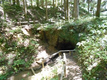
| | |Marker Title=Peg leg mine |
| | |Marker Description=[[Image:Roan Peg Leg mine entrance.jpg|150px|View of the mine]] |
| | |Marker Location=36.176135,-82.076313 |
| | }} |
| Peg Leg Mine
(log in to submit report)
|
|
|
|
| Highlight
|
View the entrance to an abandoned mine
|
| Park
|
Roan Mountain State Park
|
| Located
|
Roan Mountain, TennesseeLocation inherited from associated park
|
| Trail Marking
|
White
|
| Trail UseThings allowed to do on or near the trail
|

|
| FeaturesThings to see on or near the trail
|
Caves
|
| Difficulty Rating
|
Easy
|
| Hiking TimeTime from car and back. Includes any time hiking to access this trail.
|
20 min0.333 Hours <br />0.0208 Days <br /> round trip
|
| Distance:
|
0.2834 mi0.456 km <br /> trailStrict non-repeating trail length / 0.56 mi0.901 km <br /> round tripTypical or shortest length from the car, hike the trail, and return to car
|
| Trail Type
|
In-and-Out
|
| Low / High Point
|
2,670 ft890 Yards <br />813.816 Meters <br /> / 2,826 ft942 Yards <br />861.365 Meters <br />
|
| Elev. Gain/LossSee link for details of calculation. Gain/Loss is direction dependent.
|
152 ft46.33 Meters <br /> / (0 ft0 Meters <br />) – West-to-East
|
| Trip ReportsFrom user "hiked it" submissions<br />Recent is within last 90 days
|
No hikes logged yet
|
| NearbyWithin 5 mi<br />Click link to view list
|
11 trails / 49.8 mi of trail
|
| Parking
|
36° 10' 35.22" N, 82° 4' 45.91" W Map
|
| Trailhead
|
36° 10' 34.79" N, 82° 4' 44.40" W Map
|
Loading map... {"type":"ROADMAP","minzoom":false,"maxzoom":false,"types":["ROADMAP","SATELLITE","HYBRID","TERRAIN"],"mappingservice":"googlemaps3","width":"100%","height":"180px","centre":false,"title":"","label":"","icon":"","lines":[],"polygons":[],"circles":[],"rectangles":[],"copycoords":false,"static":false,"visitedicon":"","wmsoverlay":false,"zoom":8,"layers":[],"controls":[""],"zoomstyle":"DEFAULT","typestyle":"DEFAULT","autoinfowindows":false,"resizable":false,"kmlrezoom":false,"poi":true,"cluster":false,"clustergridsize":60,"clustermaxzoom":20,"clusterzoomonclick":true,"clusteraveragecenter":true,"clusterminsize":2,"imageoverlays":[],"kml":[],"gkml":[],"searchmarkers":"","fullscreen":false,"scrollwheelzoom":false,"locations":[{"text":"\u003Cb\u003E\u003Cdiv class=\"mw-parser-output\"\u003E\u003Cp\u003EPeg Leg Mine\n\u003C/p\u003E\u003C/div\u003E\u003C/b\u003E\u003Cdiv class=\"mw-parser-output\"\u003E\u003Cp\u003EMain Parking Location\n\u003C/p\u003E\u003C/div\u003E","title":"Peg Leg Mine\n","link":"","lat":36.1764500000000026602720026858150959014892578125,"lon":-82.079419999999998935891198925673961639404296875,"icon":""}]} |
| Show In Google Maps
|
Loading map...
{"format":"googlemaps3","type":"TERRAIN","minzoom":false,"maxzoom":false,"types":["SATELLITE","HYBRID","TERRAIN"],"limit":50,"offset":0,"link":"none","sort":[""],"order":[],"headers":"show","mainlabel":"","intro":"","outro":"","searchlabel":"... further results","default":"","import-annotation":false,"width":"auto","height":"600px","centre":false,"title":"","label":"","icon":"","lines":[],"polygons":[],"circles":[],"rectangles":[],"copycoords":false,"static":false,"visitedicon":"","wmsoverlay":false,"zoom":false,"layers":[],"controls":["pan","zoom","type","scale","streetview","rotate"],"zoomstyle":"DEFAULT","typestyle":"DEFAULT","autoinfowindows":false,"resizable":false,"kmlrezoom":true,"poi":true,"cluster":false,"clustergridsize":60,"clustermaxzoom":20,"clusterzoomonclick":true,"clusteraveragecenter":true,"clusterminsize":2,"imageoverlays":[],"kml":[],"gkml":["https://tehcc.org/clubwiki/images/Peg_Leg_Mine.kml"],"searchmarkers":"","fullscreen":false,"scrollwheelzoom":false,"showtitle":false,"hidenamespace":true,"template":"Map Balloon Template","userparam":"","activeicon":"","pagelabel":false,"ajaxcoordproperty":"","ajaxquery":"","locations":[{"text":"\u003Cp\u003E\u003Cb\u003E\u003Ca class=\"mw-selflink selflink\"\u003EPeg Leg Mine\u003C/a\u003E\u003C/b\u003E\u003Cbr /\u003E\u003C/p\u003E\u003Chr /\u003E\u003Cp\u003E0.28\u0026#160;Mi (0.46\u0026#160;km)\u003Cbr /\u003EDifficulty: Easy\u003Cbr /\u003EMarking: White\u003C/p\u003E","title":"Peg Leg Mine","link":"","lat":36.17633000000000009777068044058978557586669921875,"lon":-82.0789999999999935198502498678863048553466796875,"icon":"/clubwiki/images/MarkerT.png"},{"text":"\u003Cp\u003E\u003Cb\u003ETrail split\u003C/b\u003E\u003Cbr /\u003E\u003C/p\u003E\u003Chr /\u003E\u003Cp\u003EContinue right for the trail, unknown trail to the left\u003C/p\u003E","title":"Peg Leg Mine","link":"","lat":36.17688199999999909550751908682286739349365234375,"lon":-82.078970999999995683538145385682582855224609375,"icon":"/clubwiki/images/MarkerG.png"},{"text":"\u003Cp\u003E\u003Cb\u003EPeg leg mine\u003C/b\u003E\u003Cbr /\u003E\u003C/p\u003E\u003Chr /\u003E\u003Cp\u003E\u003Ca href=\"/wiki/File:Roan_Peg_Leg_mine_entrance.jpg\" class=\"image\" title=\"View of the mine\"\u003E\u003Cimg alt=\"View of the mine\" src=\"/clubwiki/images/thumb/Roan_Peg_Leg_mine_entrance.jpg/150px-Roan_Peg_Leg_mine_entrance.jpg\" decoding=\"async\" width=\"150\" height=\"113\" srcset=\"/clubwiki/images/thumb/Roan_Peg_Leg_mine_entrance.jpg/225px-Roan_Peg_Leg_mine_entrance.jpg 1.5x, /clubwiki/images/thumb/Roan_Peg_Leg_mine_entrance.jpg/300px-Roan_Peg_Leg_mine_entrance.jpg 2x\" data-file-width=\"1024\" data-file-height=\"768\" /\u003E\u003C/a\u003E\u003C/p\u003E","title":"Peg Leg Mine","link":"","lat":36.1761350000000021509549696929752826690673828125,"lon":-82.076312999999998964995029382407665252685546875,"icon":"/clubwiki/images/MarkerI.png"},{"text":"\u003Cp\u003E\u003Cb\u003EParking\u003C/b\u003E\u003Cbr /\u003E\u003C/p\u003E\u003Chr /\u003E\u003Cp\u003EMain parking for trail and visitor's center\u003C/p\u003E","title":"Peg Leg Mine","link":"","lat":36.1765410000000002810338628478348255157470703125,"lon":-82.0794020000000017489583115093410015106201171875,"icon":"/clubwiki/images/MarkerA.png"},{"text":"\u003Cp\u003E\u003Cb\u003EViewing platform\u003C/b\u003E\u003Cbr /\u003E\u003C/p\u003E\u003Chr /\u003E\u003Cp\u003E\u003Ca href=\"/wiki/File:Roan_Peg_Leg_view_from_platform.jpg\" class=\"image\" title=\"View from the platform\"\u003E\u003Cimg alt=\"View from the platform\" src=\"/clubwiki/images/thumb/Roan_Peg_Leg_view_from_platform.jpg/150px-Roan_Peg_Leg_view_from_platform.jpg\" decoding=\"async\" width=\"150\" height=\"113\" srcset=\"/clubwiki/images/thumb/Roan_Peg_Leg_view_from_platform.jpg/225px-Roan_Peg_Leg_view_from_platform.jpg 1.5x, /clubwiki/images/thumb/Roan_Peg_Leg_view_from_platform.jpg/300px-Roan_Peg_Leg_view_from_platform.jpg 2x\" data-file-width=\"1024\" data-file-height=\"768\" /\u003E\u003C/a\u003E\u003C/p\u003E","title":"Peg Leg Mine","link":"","lat":36.17671899999999851615939405746757984161376953125,"lon":-82.0776149999999944384398986585438251495361328125,"icon":"/clubwiki/images/MarkerE.png"}]}
Download KML / Upload new version / KML File Page / Create Profile Chart / gpsvisualizer Map
Trail Overview[edit]
This is part of the Roan Mountain State Park trail system
How to get there[edit]
From the visitor center walk between the water wheel building and the bathrooms. Head left and go under the waterwheel flume to begin the hike.
Route Description[edit]
Short trail beginning at the visitor center.
| Feet Out
|
Peg Leg Mine
|
Feet Back
|
Elevation (ft)
|
| 0
|
Trail head at Visitor's Center
|
1,596
|
2,714
|
| 198
|
Unknown split, continue right for trail
|
1,398
|
2,697
|
| 1,015
|
Viewing platform
|
581
|
2,850
|
| 1,596
|
Peg Leg Mine
|
0
|
2,909
|
Typical Conditions[edit]
Being a TN state park, the dirt and gravel trails are kept in good condition. Some of the trail sections are steep, thus can be slippery after a rain.
Misc. Information[edit]
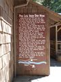
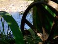
General John T. Wilder purchased this land as part of a 7,000 acre purchase for $25.15 an acre in 1870. One of the mines he started became known as the Peg Leg Mine. The mine was mined for iron ore. The ore was sent to a smelter across the Doe River. The water wheel, similar to the one near the visitor's center, was used to lift and drop a 500-lb hammer and to crush the ore. The ore would then be loaded on to rail cars and sent to Cranberry, North Carolina for further processing before making its way to Ohio and Pennsylvania to a steel mill.
Sign at the Visitor's Center
Entrance to the Peg Leg Mine
View from the viewing platform
Water wheel showing the non-meshing gear