Peg Leg Mine: Difference between revisions
Jump to navigation
Jump to search
(add kml) |
(Add pictures) |
||
| Line 1: | Line 1: | ||
<!-- The following few lines create the "Infobox" table template. Please scroll down to edit the main content of the article. --> | <!-- The following few lines create the "Infobox" table template. Please scroll down to edit the main content of the article. --> | ||
{{Infobox Trail | {{Infobox Trail | ||
| Image Name = | | Image Name = Roan Peg Leg mine entrance.jpg | ||
| Park = Roan Mountain State Park | | Park = Roan Mountain State Park | ||
| City = Roan Mountain | | City = Roan Mountain | ||
| Line 51: | Line 51: | ||
<!-- Place any pictures from this trail below. Ideally we would have a picture of the trailhead to help people know when they found it --> | <!-- Place any pictures from this trail below. Ideally we would have a picture of the trailhead to help people know when they found it --> | ||
<!-- Add a picture by typing Image:imagename.extension --> | <!-- Add a picture by typing Image:imagename.extension --> | ||
Image: | Image:Peg Leg Mine history.jpg|History of the mine | ||
Image:Roan Peg Leg view from platform.jpg|View from the platform | |||
Image:View of the Roan water wheel.jpg|Non-meshing gear of water wheel | |||
<!-- Do not remove the end gallery code.--> | <!-- Do not remove the end gallery code.--> | ||
</gallery> | </gallery> | ||
Revision as of 11:59, 20 September 2015
| |||||||||||||||||||||||||||||||||||||||||||||

Trail Overview
This is part of the Roan Mountain State Park trail system
How to get there
From the visitor center walk between the water wheel building and the bathrooms. Head left and go under the penstock to begin the hike.
Route Description
Short trail beginning at the visitor center.
Typical Conditions
Being a TN state park, the dirt and gravel trails are kept in good condition. Some of the trail sections are steep, thus can be slippery after a rain.
Misc. Information
Maps
Photos
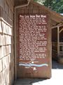
History of the mine
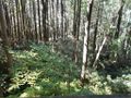
View from the platform
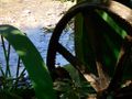
Non-meshing gear of water wheel


