Overmountain Victory National Historic Trail
| |||||||||||||||||||||||||||||||||||||
Trail Overview
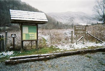
While the Overmountain Victory National Historic Trail stretches 330 miles, there are only a few segments that are not paved highway and open to the public. This page describes the 3.75 mile section located in the Hampton Creek Cove State Natural Area.
How to get there
From Johnson City, TN
- Head south on Roan Street for 3.5 miles passing under I-26.
- Take left/east onto TN359/Okolona Road and travel 1.4 miles.
- Take right/south onto TN361 over to US19E for nine miles. The road starts as Laurels Road, then Dry Creek Road and finally Gap Creek Road.
- Travel US19E for ten miles to town of Roan Mountain.
- Take right/south onto TN143.
- Cross bridge and then take left/east onto Stratton Street.
- Take right/south onto Old Highway 143/Sawdust Trail to Cloudland Elem School.
- Turn left/east onto Hampton Creek Road and proceed three miles.
- Parking area is on left/east side of road.
Route Description
The Overmountain Trail begins at the parking lot follows the Left Prong creek up Yellow Mountain for 3.75 miles to intersection with the Appalachian Trail at the gap. The path continues into North Carolina for another 1.5 miles.
Typical Conditions
Fees, Permits, etc.
No permit or fee. The nature area closes at dusk.
After the Hike
Misc. Information
Hampton Creek Cove is a 693-acre natural area. The official TN.gov Hampton Creek Cove webpage including map.
National Park Service website for OVMT
Maps
<googlemap lat="36.14" lon="-82.055733" type="terrain" zoom="14" height="600" scale="yes" icons="http://tehcc.org/clubwiki/kml/marker{label}.png"> http://tehcc.org/clubwiki/kml/Placeholder_trail.kml (A) 36.152383,-82.055733 Parking at Hampton Creek Cove State Natural Area (G) 36.125815,-82.051335 Intersection with Appalachian Trail </googlemap>


