|
|
| (14 intermediate revisions by 4 users not shown) |
| Line 1: |
Line 1: |
| <!-- The following few lines create the "Infobox" table template. Please scroll down to edit the main content of the article. -->
| | {{Trail |
| {{Infobox Trail | | |Banner Image=File:WPSP Overlook Trail sign.jpg |
| | Image Name = WPSP Overlook Trail sign.jpg
| | |Park=Warriors' Path State Park |
| | City = Kingsport
| | |Trail Marking=None |
| | State = Tennessee
| | |Trail Use=Hiking |
| | Trail Use = {{Hike}} {{Dogs}}
| | |Difficulty Rating=Easy |
| | Difficulty Rating = Easy
| | |Hike Time=30 min |
| | Hike Time = 0.5
| | |Trail Distance=0.73 mi |
| | Distance = 0.8
| | |Round Trip Distance=1.46 mi |
| | Elevation Gain = 75
| | |Trail Type=In-and-Out |
| | High Point = 1365
| | |High Point=1,401 ft |
| | Latitude = N36°29.417
| | |Low Point=1,289 ft |
| | Longitude = W82°28.631
| | |Elevation Gain=73 ft |
| | Medical = Indian Path Hospital
| | |Elevation Loss=86 ft |
| <!-- DON'T EDIT THE GOOGLEMAP TAG -->
| | |Elevation Change Direction=East-to-West |
| | googlemap =
| | |Parking location=36.49028, -82.47718 |
| <googlemap lat="36.49028" lon="-82.47718" zoom="12" width="270" type="map" height="180" selector="no" controls="small">
| | |Trailhead location=36.49028, -82.47718 |
| 36.49028,-82.47718 | |
| Overlook Trail
| |
| </googlemap>
| |
| }} | | }} |
| <!-- End Infobox template table--> | | <display_map type="terrain" zoom="14" height="500" width="auto" kml="https://tehcc.org/clubwiki/kml/WPSP_Overlook_Trail_(spur).kml, |
| | https://tehcc.org/clubwiki/kml/WPSP_Overlook_Trail.kml"> |
|
| |
|
| <!-- Start of Main Page -->
| | |
| | 36.49028,-82.47718~Overlook trailhead at soccer field parking~ ~MarkerA.png |
| | 36.486698,-82.480163~Double Blaze-RR Tie steps~[[Image:WPSP Overlook Trail sign.jpg|150px|Trailhead sign]]~MarkerG.png |
| | 36.48795,-82.47944~Overlook #1~ ~MarkerE.png |
| | 36.48719,-82.47995~Overlook #2~[[Image:WPSP Overlook Trail - Viewing I-81 Bridge.jpg|150px|I-81 Bridge over Ft. Patrick Henry Lake]]~MarkerE.png |
| | 36.49072,-82.48223~Darrell's Dream boundless playground~[[Image:WPSP_Darrel's_Dream_playground.jpg|150px]]~MarkerO.png |
| | </display_map> |
| | |
| | __TOC__ |
|
| |
|
| == Trail Overview == | | == Trail Overview == |
| <!-- Enter a overview of the trail. What attracts you to this trail, points of interest, types of flowers, lakes, and peaks that you see along the way. --> | | <!-- Enter a overview of the trail. What attracts you to this trail, points of interest, types of flowers, lakes, and peaks that you see along the way. --> |
| Located in [[Warriors Path State Park]]. Short loop running along a ridge overlooking Ft. Patrick Henry Lake southeast of the soccer fields. | | Located in [[Warriors' Path State Park]]. Can be hiked as a short loop to the overlooks or as a long loop utilizing the disc golf course. Overlooks have nice views of lake and Interstate 81 bridge. |
|
| |
|
| == How to get there == | | == How to get there == |
| Line 39: |
Line 45: |
| == Route Description== | | == Route Description== |
| <!-- Detailed description of the route. Is there any side trails that are worth traveling? --> | | <!-- Detailed description of the route. Is there any side trails that are worth traveling? --> |
| Trailhead appears to be a different location than what indicated on park map. Follow the light green blazed trail. There are many spur trails created from the neighborhood and disc golf course. The following hike detail decribes hiking the loop in a clockwise direction. | | Trailhead appears to be a different location than what indicated on park map. Follow the light green blazed trail. There are many spur trails created from the neighborhood and disc golf course. |
| | |
| | Double trail route to the overlooks with many connector trails in between. Trail eventually connects with the Domtar Cabin overlooking the lake. Trail then loops along back park boundary where you are literately looking into peoples back yards. Trail ends at Frisbee golf course. |
| | |
| | The following hike detail describes hiking the loop in a clockwise direction. |
|
| |
|
| {| class="wikitable" border="1" | | {| class="wikitable" border="1" |
| Line 79: |
Line 89: |
| |Back at trailhead. | | |Back at trailhead. |
| |} | | |} |
| | |
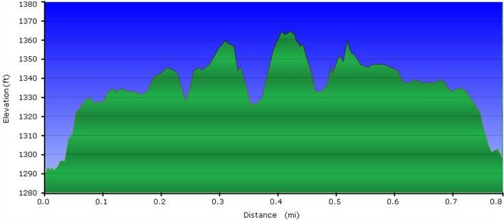
| | :::Below trail profile for walking the loop clockwise. Note only 100 ft elevation scale, thus easy. |
| | [[File:WPSP Overlook Trail profile.JPG]] |
|
| |
|
| == Typical Conditions == | | == Typical Conditions == |
| Line 91: |
Line 104: |
| <!-- Other things to check out while you're in the area. Restaurants, attractions, monuments, etc... --> | | <!-- Other things to check out while you're in the area. Restaurants, attractions, monuments, etc... --> |
| For families with pre-school to early elementary children, the Darrell's Dream boundless playground offers many ways to burn off excess energy. | | For families with pre-school to early elementary children, the Darrell's Dream boundless playground offers many ways to burn off excess energy. |
|
| |
| == Misc. Information ==
| |
| <!-- Enter any additional information that doesn't fit an any other fields. -->
| |
|
| |
|
| |
| == Maps ==
| |
| <!-- You can place pictures, PDF's, links, or even create a Google map with your waypoints and place it here. -->
| |
| <googlemap version="0.9" lat="36.49028" lon="-82.47718" type="terrain" zoom="15" width="400" height="350" scale="yes" controls="large" icons="http://tehcc.org/clubwiki/kml/marker{label}.png">
| |
| http://tehcc.org/clubwiki/kml/WPSP_Overlook_Trail.kml
| |
| (A) 36.49028,-82.47718
| |
| Overlook trailhead at soccer field parking
| |
| (G) 36.486698,-82.480163
| |
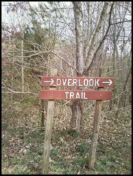
| [[Image:WPSP Overlook Trail sign.jpg|150px|Trailhead sign]]
| |
| Double Blaze-RR Tie steps
| |
| (E) 36.48795,-82.47944
| |
| Overlook #1
| |
| (E) 36.48719,-82.47995
| |
| Overlook #2
| |
| [[Image:WPSP Overlook Trail - Viewing I-81 Bridge.jpg|150px|I-81 Bridge over Ft. Patrick Henry Lake]]
| |
| </googlemap>
| |
|
| |
|
| |
| :::Below trail profile for walking the loop clockwise. Note only 100 ft elevation scale, thus easy.
| |
| [[File:WPSP Overlook Trail profile.JPG]]
| |
|
| |
| [http://www.state.tn.us/environment/parks/WarriorsPath/pdf/WPTRL.pdf State Park Map and Trail Brochure]
| |
|
| |
| == Photos ==
| |
| <gallery>
| |
| <!-- Place any pictures from this trail below. Ideally we would have a picture of the trailhead to help people know when they found it -->
| |
| <!-- Add a picture by typing Image:imagename.extension -->
| |
| Image:WPSP Overlook Trail path.jpg|Overlook Trail path thru woods
| |
| Image:WPSP Overlook Trail - Viewing I-81 Bridge.jpg|Viewing I-81 Bridge over Ft. Patrick Henry Lake
| |
| <!-- Do not remove the end gallery code.-->
| |
| </gallery>
| |
|
| |
| <!-- Finally add the trail to any Categories it should belong to. Please keep the State category. To make a new category just type [[Category:mycategory]]. Keep in mind categories are case sensitive. Check here ClubWIKI:Categorization_Plan for our list of categories that we are using -->
| |
| [[Category:Tennessee]] [[Category:Warriors Path State Park]] [[Category:Kingsport]] [[Category:Dog Friendly]] [[Category:Easy]]
| |
| [[Category:Overlook]]
| |
| Overlook
(log in to submit report)
|
|
|
|
| Park
|
Warriors' Path State Park
|
| Located
|
Kingsport, TennesseeLocation inherited from associated park
|
| Trail Marking
|
None
|
| Trail UseThings allowed to do on or near the trail
|

|
| FeaturesThings to see on or near the trail
|
|
| Difficulty Rating
|
Easy
|
| Hiking TimeTime from car and back. Includes any time hiking to access this trail.
|
30 min0.5 Hours <br />0.0313 Days <br /> round trip
|
| Distance:
|
0.73 mi1.175 km <br /> trailStrict non-repeating trail length / 1.46 mi2.35 km <br /> round tripTypical or shortest length from the car, hike the trail, and return to car
|
| Trail Type
|
In-and-Out
|
| Low / High Point
|
1,289 ft429.667 Yards <br />392.887 Meters <br /> / 1,401 ft467 Yards <br />427.025 Meters <br />
|
| Elev. Gain/LossSee link for details of calculation. Gain/Loss is direction dependent.
|
73 ft22.25 Meters <br /> / (86 ft26.213 Meters <br />) – East-to-West
|
| Trip ReportsFrom user "hiked it" submissions<br />Recent is within last 90 days
|
6 logged hikes (0 recent)
|
| NearbyWithin 5 mi<br />Click link to view list
|
25 trails / 20.0 mi of trail
|
| Parking
|
36° 29' 25.01" N, 82° 28' 37.85" W Map
|
| Trailhead
|
36° 29' 25.01" N, 82° 28' 37.85" W Map
|
Loading map... {"type":"ROADMAP","minzoom":false,"maxzoom":false,"types":["ROADMAP","SATELLITE","HYBRID","TERRAIN"],"mappingservice":"googlemaps3","width":"100%","height":"180px","centre":false,"title":"","label":"","icon":"","lines":[],"polygons":[],"circles":[],"rectangles":[],"copycoords":false,"static":false,"visitedicon":"","wmsoverlay":false,"zoom":8,"layers":[],"controls":[""],"zoomstyle":"DEFAULT","typestyle":"DEFAULT","autoinfowindows":false,"resizable":false,"kmlrezoom":false,"poi":true,"cluster":false,"clustergridsize":60,"clustermaxzoom":20,"clusterzoomonclick":true,"clusteraveragecenter":true,"clusterminsize":2,"imageoverlays":[],"kml":[],"gkml":[],"searchmarkers":"","fullscreen":false,"scrollwheelzoom":false,"locations":[{"text":"\u003Cb\u003E\u003Cdiv class=\"mw-parser-output\"\u003E\u003Cp\u003EOverlook\n\u003C/p\u003E\u003C/div\u003E\u003C/b\u003E\u003Cdiv class=\"mw-parser-output\"\u003E\u003Cp\u003EMain Parking Location\n\u003C/p\u003E\u003C/div\u003E","title":"Overlook\n","link":"","lat":36.4902799999999984947862685658037662506103515625,"lon":-82.477180000000004156390787102282047271728515625,"icon":""}]} |
| Show In Google Maps
|
Loading map...
{"type":"TERRAIN","minzoom":false,"maxzoom":false,"types":["ROADMAP","SATELLITE","HYBRID","TERRAIN"],"mappingservice":"googlemaps3","width":"auto","height":"500px","centre":false,"title":"","label":"","icon":"","lines":[],"polygons":[],"circles":[],"rectangles":[],"copycoords":false,"static":false,"visitedicon":"","wmsoverlay":false,"zoom":14,"layers":[],"controls":["pan","zoom","type","scale","streetview","rotate"],"zoomstyle":"DEFAULT","typestyle":"DEFAULT","autoinfowindows":false,"resizable":false,"kmlrezoom":false,"poi":true,"cluster":false,"clustergridsize":60,"clustermaxzoom":20,"clusterzoomonclick":true,"clusteraveragecenter":true,"clusterminsize":2,"imageoverlays":[],"kml":["https://tehcc.org/clubwiki/kml/WPSP_Overlook_Trail_(spur).kml","https://tehcc.org/clubwiki/kml/WPSP_Overlook_Trail.kml"],"gkml":[],"searchmarkers":"","fullscreen":false,"scrollwheelzoom":false,"locations":[{"text":"\u003Cdiv class=\"mw-parser-output\"\u003E\u003Cp\u003EOverlook trailhead at soccer field parking\n\u003C/p\u003E\u003C/div\u003E","title":"Overlook trailhead at soccer field parking\n","link":"","lat":36.4902799999999984947862685658037662506103515625,"lon":-82.477180000000004156390787102282047271728515625,"icon":"/clubwiki/images/MarkerA.png"},{"text":"\u003Cb\u003E\u003Cdiv class=\"mw-parser-output\"\u003E\u003Cp\u003EDouble Blaze-RR Tie steps\n\u003C/p\u003E\u003C/div\u003E\u003C/b\u003E\u003Cdiv class=\"mw-parser-output\"\u003E\u003Cp\u003E\u003Ca href=\"/wiki/File:WPSP_Overlook_Trail_sign.jpg\" class=\"image\" title=\"Trailhead sign\"\u003E\u003Cimg alt=\"Trailhead sign\" src=\"/clubwiki/images/thumb/WPSP_Overlook_Trail_sign.jpg/150px-WPSP_Overlook_Trail_sign.jpg\" decoding=\"async\" width=\"150\" height=\"199\" srcset=\"/clubwiki/images/thumb/WPSP_Overlook_Trail_sign.jpg/225px-WPSP_Overlook_Trail_sign.jpg 1.5x, /clubwiki/images/WPSP_Overlook_Trail_sign.jpg 2x\" data-file-width=\"265\" data-file-height=\"351\" /\u003E\u003C/a\u003E\n\u003C/p\u003E\u003C/div\u003E","title":"Double Blaze-RR Tie steps\n","link":"","lat":36.48669799999999696638042223639786243438720703125,"lon":-82.48016300000000455838744528591632843017578125,"icon":"/clubwiki/images/MarkerG.png"},{"text":"\u003Cdiv class=\"mw-parser-output\"\u003E\u003Cp\u003EOverlook #1\n\u003C/p\u003E\u003C/div\u003E","title":"Overlook #1\n","link":"","lat":36.4879499999999978854248183779418468475341796875,"lon":-82.4794399999999967576513881795108318328857421875,"icon":"/clubwiki/images/MarkerE.png"},{"text":"\u003Cb\u003E\u003Cdiv class=\"mw-parser-output\"\u003E\u003Cp\u003EOverlook #2\n\u003C/p\u003E\u003C/div\u003E\u003C/b\u003E\u003Cdiv class=\"mw-parser-output\"\u003E\u003Cp\u003E\u003Ca href=\"/wiki/File:WPSP_Overlook_Trail_-_Viewing_I-81_Bridge.jpg\" class=\"image\" title=\"I-81 Bridge over Ft. Patrick Henry Lake\"\u003E\u003Cimg alt=\"I-81 Bridge over Ft. Patrick Henry Lake\" src=\"/clubwiki/images/thumb/WPSP_Overlook_Trail_-_Viewing_I-81_Bridge.jpg/150px-WPSP_Overlook_Trail_-_Viewing_I-81_Bridge.jpg\" decoding=\"async\" width=\"150\" height=\"199\" srcset=\"/clubwiki/images/thumb/WPSP_Overlook_Trail_-_Viewing_I-81_Bridge.jpg/225px-WPSP_Overlook_Trail_-_Viewing_I-81_Bridge.jpg 1.5x, /clubwiki/images/WPSP_Overlook_Trail_-_Viewing_I-81_Bridge.jpg 2x\" data-file-width=\"265\" data-file-height=\"351\" /\u003E\u003C/a\u003E\n\u003C/p\u003E\u003C/div\u003E","title":"Overlook #2\n","link":"","lat":36.48718999999999823558027856051921844482421875,"lon":-82.479950000000002319211489520967006683349609375,"icon":"/clubwiki/images/MarkerE.png"},{"text":"\u003Cb\u003E\u003Cdiv class=\"mw-parser-output\"\u003E\u003Cp\u003EDarrell's Dream boundless playground\n\u003C/p\u003E\u003C/div\u003E\u003C/b\u003E\u003Cdiv class=\"mw-parser-output\"\u003E\u003Cp\u003E\u003Ca href=\"/wiki/File:WPSP_Darrel%27s_Dream_playground.jpg\" class=\"image\"\u003E\u003Cimg alt=\"WPSP Darrel\u0026#39;s Dream playground.jpg\" src=\"/clubwiki/images/thumb/WPSP_Darrel%27s_Dream_playground.jpg/150px-WPSP_Darrel%27s_Dream_playground.jpg\" decoding=\"async\" width=\"150\" height=\"113\" srcset=\"/clubwiki/images/thumb/WPSP_Darrel%27s_Dream_playground.jpg/225px-WPSP_Darrel%27s_Dream_playground.jpg 1.5x, /clubwiki/images/thumb/WPSP_Darrel%27s_Dream_playground.jpg/300px-WPSP_Darrel%27s_Dream_playground.jpg 2x\" data-file-width=\"600\" data-file-height=\"450\" /\u003E\u003C/a\u003E\n\u003C/p\u003E\u003C/div\u003E","title":"Darrell's Dream boundless playground\n","link":"","lat":36.49072000000000315367287839762866497039794921875,"lon":-82.4822300000000012687451089732348918914794921875,"icon":"/clubwiki/images/MarkerO.png"}]}
Trail Overview[edit]
Located in Warriors' Path State Park. Can be hiked as a short loop to the overlooks or as a long loop utilizing the disc golf course. Overlooks have nice views of lake and Interstate 81 bridge.
How to get there[edit]
Directions to main entrance found on Warriors Path State Park webpage.
- Follow the main park road as it winds past the pool, campground, and turnoff for Duck Island.
- Take left towards the fishing piers, but continue back to the boat ramp.
- Park at the far (east) side of the soccer fields.
- Sign for trailhead can be seen nearby.
Warning: This area will be very busy during soccer and boating seasons.
Route Description[edit]
Trailhead appears to be a different location than what indicated on park map. Follow the light green blazed trail. There are many spur trails created from the neighborhood and disc golf course.
Double trail route to the overlooks with many connector trails in between. Trail eventually connects with the Domtar Cabin overlooking the lake. Trail then loops along back park boundary where you are literately looking into peoples back yards. Trail ends at Frisbee golf course.
The following hike detail describes hiking the loop in a clockwise direction.
| Distance
|
Overlook Trail
|
| 0.00 mi
|
Parking at trailhead by chain gate. Head left into the woods.
|
| 230 ft
|
Split. Main trail continues ahead while unmarked spur heads left for more view of the lake and rejoins later.
|
| 370 ft
|
Spur trail rejoins.
|
| 0.22 mi
|
Spur trail to first overlook.
|
| 0.26 mi
|
Split in blazed trail for loop. Most will continue straight for main overlook.
|
| 0.32 mi
|
Double blaze. Head right up RR tie stairs. Straight is unmarked spur trail into neighborhood.
|
| 0.36 mi
|
Keep right. Spur into neighborhood.
|
| 0.44 mi
|
Double blaze. Left heads to disc golf course. Right to continue on trail.
|
| 0.48 mi
|
Return to start of loop. Turn left for trailhead.
|
| 0.52 mi
|
Slight right for trail through woods.
|
| 0.80 mi
|
Back at trailhead.
|
- Below trail profile for walking the loop clockwise. Note only 100 ft elevation scale, thus easy.
Typical Conditions[edit]
Heavily used park trail is generally wide and kept open of the blowdowns (mostly pine dying due to the bore beetle).
Fees, Permits, etc.[edit]
No fee required.
After the Hike[edit]
For families with pre-school to early elementary children, the Darrell's Dream boundless playground offers many ways to burn off excess energy.

