Lone Oak Trail: Difference between revisions
m (add needs) |
(Couple of updates after talking with Johnson City Nature Program Coordinator) |
||
| Line 6: | Line 6: | ||
| City = Johnson City | | City = Johnson City | ||
| State = Tennessee | | State = Tennessee | ||
| Marking = Orange | | Marking = Orange Rectangle | ||
| Trail Use = {{Hike}} {{Dogs}} | | Trail Use = {{Hike}} {{Dogs}} | ||
| Difficulty Rating = Medium | | Difficulty Rating = Medium | ||
| Line 67: | Line 67: | ||
==Fees, Permits, etc. == | ==Fees, Permits, etc. == | ||
<!-- Please list any Fees, Permits, Regulations, etc. that may be required on this trail.--> | <!-- Please list any Fees, Permits, Regulations, etc. that may be required on this trail.--> | ||
No fees or permits required | No fees or permits required. This trail is not actually in Buffalo Mountain Park but passes through Cherokee National Forest and some private land to reach the park. | ||
== After the Hike == | == After the Hike == | ||
| Line 74: | Line 74: | ||
== Misc. Information == | == Misc. Information == | ||
<!-- Enter any additional information that doesn't fit an any other fields. Does this trail require any permits for overnight? parking? --> | <!-- Enter any additional information that doesn't fit an any other fields. Does this trail require any permits for overnight? parking? --> | ||
The trail was rerouted by Tom Dosser, long-time hiker and supporter, when he was 77 years old, which added around 0.7 miles to the 1.2 miles shown on the park map. However, the route now is more achievable due to the many switchbacks. | The trail was rerouted by late Tom Dosser, long-time hiker and supporter, when he was 77 years old, which added around 0.7 miles to the 1.2 miles shown on the park map. However, the route now is more achievable due to the many switchbacks. | ||
== Maps == | == Maps == | ||
Revision as of 10:03, 26 November 2018
| |||||||||||||||||||||||||||||||||||||||||||||

Trail Overview
Steep hike UP (13.5% grade) the backside of Buffalo Mountain Park to Tip-Top overlook for area views
How to get there
Within Johnson City:
- At I-26 Exit 24, take US-321/University Parkway west.
- Turn left/south at Cherokee Road and travel a couple of miles to the Cherokee Elementary School.
- Turn left/south onto Lone Oak Road, which becomes Dry Creek Road.
- After mile and half, small brown trailhead sign (see gallery) on right.
- Pull-off parking just past the sign.
Route Description
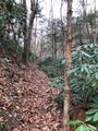
The trail begins along the creek, then quickly ascends to the ridgeline via twenty switchbacks (someone has written roman numerals on several). The path continues upward along or near the ridge. It passes a wooden “Lone Oak Tr” at an intersection with an unmarked and unnamed trail heading downhill. The path continues on a sidehill route up to a ridge junction, and then a sharp left up to Tip-Top overlook.
A few orange blazes are on the trail up near Tip-Top, but no markings observed on the relocation.
Several linear routes are available by staging a vehicle in the main or alternate park lots. After hiking up on Lone Oak, continuing onto High Ridge Trail, Fork Ridge Trail over to the Towers, and down White Rock Trail will provide more overlook views while covering just under five miles.
Typical Conditions
This section of Buffalo Mountain Park suffered a fire in May 2008, thus most of the trail will have summertime views until the trees grow back. Portions of the trail were relocated in 2007 as a path dug into the hillside, sometimes supported with rocks and logs. If a “double track” refers to being wide enough for two people to walk side-by-side, then this trail is a single to a half track. It narrows in place to only be as wide as a hiking boot. Trekking poles are recommended to maintain your balance. Would not suggest taking this trail in early spring as the dirt tread will be muddy and slippery. Best time of year might be fall to see the surrounding mountain in full leaf color.
Fees, Permits, etc.
No fees or permits required. This trail is not actually in Buffalo Mountain Park but passes through Cherokee National Forest and some private land to reach the park.
After the Hike
Misc. Information
The trail was rerouted by late Tom Dosser, long-time hiker and supporter, when he was 77 years old, which added around 0.7 miles to the 1.2 miles shown on the park map. However, the route now is more achievable due to the many switchbacks.
Maps
The Lone Oak Trail is shown as the orange line, while High Ridge Trail is in blue.
Photos
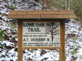
Dosser sign
Trailhead from Dry Creek Road
