|
|
|
|
|
| Trail Name
|
Little Stony Creek Falls
|
| Nearest City
|
Dungannon
|
| State
|
Virginia
|
| Trail Marking
|
{{{Marking}}}
|
| Trail Use/Features
|
 
|
| Difficulty Rating
|
Moderate
|
| Hiking Time
|
3-4"-4" is not declared as a valid unit of measurement for this property.
|
| Distance, round-trip
|
5.25.2 mi <br />8.369 km <br />
|
| Climb/Descent Elevation
|
800800 Feet <br />243.84 Meters <br /> / {{{Elevation Loss}}}"{{{Elevation Loss}}}" is not a number.
|
| High Point
|
*"*" is not a number.
|
| Nearest Medical
|
Kingsport, TN
|
| Trip Reports
|
Click Here
|
|
|
Loading map... {"type":"ROADMAP","minzoom":false,"maxzoom":false,"types":["ROADMAP","SATELLITE","HYBRID","TERRAIN"],"mappingservice":"googlemaps3","width":"270px","height":"180px","centre":false,"title":"","label":"","icon":"","lines":[],"polygons":[],"circles":[],"rectangles":[],"copycoords":false,"static":false,"visitedicon":"","wmsoverlay":false,"zoom":8,"layers":[],"controls":["zoom"],"zoomstyle":"DEFAULT","typestyle":"DEFAULT","autoinfowindows":false,"resizable":false,"kmlrezoom":false,"poi":true,"cluster":false,"clustergridsize":60,"clustermaxzoom":20,"clusterzoomonclick":true,"clusteraveragecenter":true,"clusterminsize":2,"imageoverlays":[],"kml":[],"gkml":[],"searchmarkers":"","fullscreen":false,"scrollwheelzoom":false,"locations":[{"text":"","title":"","link":"","lat":36.79471600000000108821041067130863666534423828125,"lon":-82.5471500000000020236257114447653293609619140625,"icon":""}]} |
|
| Show Large Map
|
|
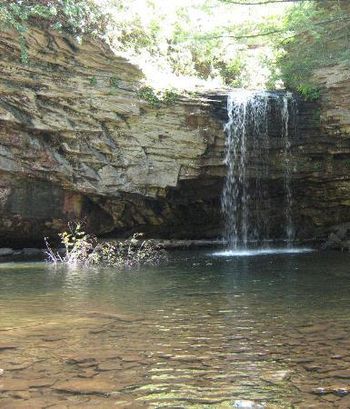
Trail Overview
Two nice waterfalls in gorge with sandstone cliffs along the sides. Hike up good trail with several bridges.
How to get there
From Gate City, VA:
- Turn onto VA 71 north (no sign here).
- After one mile, turn left on VA 72 and proceed north (through Ft. Blackmore and Dungannon, Va.) for 22.1 miles.
- Look for USFS sign, to USFS Hanging Rock Recreation Area (about 2.6 miles north of Dungannon, Va).
- At extremely sharp switchback, go straight (left side of highway) into picnic area and park.
Route Description
Hikers cross mound barriers and soon make the first of a number of fords. Continue following up creek valley.
Typical Conditions
Reported some blowdowns from 2009 storm still remaining.
Fees, Permits, etc.
Day use fee for USFS Hanging Rock Recreation Area
After the Hike
Misc. Information
Maps
Photos
