Laurel River Trail: Difference between revisions
(Five years later - time to create the page as might have a joint hike with MAHC in November) |
m (Text replacement - "http://tehcc.org/clubwiki/" to "https://tehcc.org/clubwiki/") |
||
| (27 intermediate revisions by 3 users not shown) | |||
| Line 2: | Line 2: | ||
-->{{Infobox Trail | -->{{Infobox Trail | ||
| Image Name = LaurelRiverTrail1.JPG | |||
| City = Hot Springs | |||
| State = North Carolina | |||
| Marking = Yellow Blaze | |||
| Trail Use = {{Hike}} {{Biking}} {{Dogs}} {{Fishing}} | |||
| Difficulty Rating = Medium | |||
| Hike Time = 4 Hours | |||
| Round Trip Distance = 7.2 Mi | |||
| Trail Type = In-and-Out | |||
| Elevation Gain = 240 Ft | |||
| Elevation Loss = -240 Ft | |||
| High Point = 1640 Ft | |||
| Parking coords = 35.9136,-82.75695 | |||
| Trailhead coords = 35.9124,-82.75684 | |||
| Medical = Hot Springs, NC | |||
}}<!-- | }}<!-- | ||
| Line 22: | Line 24: | ||
== Trail Overview == | == Trail Overview == | ||
<!-- Enter overview of the trail. What attracts you to this trail, points of interest, types of flowers, lakes, and peaks that you see along the way. --> | <!-- Enter overview of the trail. What attracts you to this trail, points of interest, types of flowers, lakes, and peaks that you see along the way. --> | ||
Rails-to-trail conversion - walk along Big Laurel Creek on an old railroad bed previously used to carry logs to the sawmill in the former town of Runion on the French Broad River. | Rails-to-trail conversion - walk along Big Laurel Creek on an old railroad bed previously used to carry logs to the sawmill in the former town of Runion on the French Broad River. Good place to see spring wildflowers. | ||
== How to get there == | == How to get there == | ||
| Line 32: | Line 34: | ||
#After 3.5 miles, NC-208 intersects US-25/70. | #After 3.5 miles, NC-208 intersects US-25/70. | ||
#Continue south for another 0.1 mile. | #Continue south for another 0.1 mile. | ||
#Parking along highway. | #Parking along highway for a dozen vehicles. | ||
== Route Description== | == Route Description== | ||
<!-- Detailed description of the route. | <!-- Detailed description of the route. --> | ||
From south end of the parking lot, Laurel River Trail begins on a gravel road through private property. Hikers, bikers, and campers should stay on the trail to ensure the privacy of landowners along the route. Pass two refurbished railcars on the hillside to the left. (Private property - keep away!) Cross a gravel road leading up to the highway. Pass a rental property and another home, where the power line finally ceases. After one mile, the trail becomes a thin path as it enters the Pisgah National Forest and continues at a fairly level grade. At roughly 2.5 miles, ruins from the former town of Runion are seen on the hillside. Near end of trail, an active railroad is crossed to reach the French Broad River. Reverse your direction to return to the parking lot. | |||
Laurel River Trail is especially scenic in early spring when there are many wildflowers blooming along the path and riverbanks. Bikers will find the path to be an easy ride; however, some short sections of the trail are a bit rocky and care should be taken when passing through these areas. | |||
== Typical Conditions == | == Typical Conditions == | ||
<!-- Typical conditions throughout the year of what to expect on the trail. Rocky, muddy, sandy, flowers, lots of downed trees? --> | <!-- Typical conditions throughout the year of what to expect on the trail. Rocky, muddy, sandy, flowers, lots of downed trees? --> | ||
Being a Rails-to-Trail, the gravel with | Being a Rails-to-Trail, the path is gravel with sections of dirt, uneven rock, and tree roots. Sturdy shoes are strongly suggested, but not flip-flops. Brush along the trail might grow into the path. Four crossable blowdowns were experienced in November 2017. | ||
Note that bears have been seen in the area, thus be aware and take appropriate actions if one is spotted. | |||
==Fees, Permits, etc. == | ==Fees, Permits, etc. == | ||
<!-- Please list any Fees, Permits, Regulations, etc. that may be required on this trail.--> | <!-- Please list any Fees, Permits, Regulations, etc. that may be required on this trail.--> | ||
No fees or permits are required - even for parking. | |||
Lots of dogs were seen being taken for walks. ALL had leashes. | |||
== After the Hike == | == After the Hike == | ||
<!-- Anywhere interesting to stop by since you're in the area!! --> | <!-- Anywhere interesting to stop by since you're in the area!! --> | ||
Head into Hot Springs for a meal. | Head into Hot Springs (ten minutes away) for a meal. Iron Horse Station and Spring Creek Tavern both have provided groups with good late lunches and adult beverages. There are also ice cream places for treats. | ||
== Misc. Information == | == Misc. Information == | ||
<!-- Enter any additional information that doesn't fit an any other fields. Does this trail require any permits for overnight? parking? --> | <!-- Enter any additional information that doesn't fit an any other fields. Does this trail require any permits for overnight? parking? --> | ||
Pisgah NF Trail #310 | |||
Video about the trail can been viewed here: https://www.hdcarolina.com/episode/laurel-river-trail | Video about the trail can been viewed here: https://www.hdcarolina.com/episode/laurel-river-trail | ||
== Maps == | == Maps == | ||
<!-- You can place pictures, PDF's, links, or even create a Google map with your waypoints and place it here. --> | <!-- You can place pictures, PDF's, links, or even create a Google map with your waypoints and place it here. --> | ||
<display_map center="35. | <display_map center="35.9,-82.79" type="terrain" height="550" width="auto" zoom="14" gkml="https://tehcc.org/clubwiki/kml/Laurel_River_Trail.kml"> | ||
35.9136,-82.75695~Parking~ ~MarkerA.png | 35.9136,-82.75695~Parking~ ~MarkerA.png | ||
35.884747, -82.779891~Southern Terminus~~MarkerT.png | |||
35.912480, -82.756861~Northern Terminus~~MarkerT.png | |||
</display_map> | </display_map> | ||
| Line 63: | Line 75: | ||
<gallery> | <gallery> | ||
<!-- Place any pictures from this trail below. Add a picture by typing Image:imagename.extension --> | <!-- Place any pictures from this trail below. Add a picture by typing Image:imagename.extension --> | ||
Image: | Image:French Broad River at Laurel River Trail.JPG|French Broad River | ||
Image:LaurelRiverTrail2.JPG|Active Railroad | |||
Image:LaurelRiverTrail3.JPG|Refurbished RR cars | |||
Image:LaurelRiverTrail4.jpeg|Photo by Gerald | |||
<!-- Do not remove the end gallery code.--> | <!-- Do not remove the end gallery code.--> | ||
</gallery> | </gallery> | ||
<!-- Categories. Please keep the State category. Keep in mind categories are case sensitive. --> | <!-- Categories. Please keep the State category. Keep in mind categories are case sensitive. --> | ||
[[Category:North Carolina]] [[Category: | [[Category:North Carolina]] [[Category:Medium]] [[Category:Hiking]] [[Category:Biking]] [[Category:Dog Friendly]] [[Category:Fishing]] | ||
Latest revision as of 12:12, 7 January 2023
| |||||||||||||||||||||||||||||||||||||||||

Trail Overview[edit]
Rails-to-trail conversion - walk along Big Laurel Creek on an old railroad bed previously used to carry logs to the sawmill in the former town of Runion on the French Broad River. Good place to see spring wildflowers.
How to get there[edit]
From Greeneville, TN:
- Head south out of town on TN-107/TN-70.
- Cross state line where highway becomes NC-208.
- After just under six miles, turn right to stay on NC-208. Straight becomes NC-212.
- After 3.5 miles, NC-208 intersects US-25/70.
- Continue south for another 0.1 mile.
- Parking along highway for a dozen vehicles.
Route Description[edit]
From south end of the parking lot, Laurel River Trail begins on a gravel road through private property. Hikers, bikers, and campers should stay on the trail to ensure the privacy of landowners along the route. Pass two refurbished railcars on the hillside to the left. (Private property - keep away!) Cross a gravel road leading up to the highway. Pass a rental property and another home, where the power line finally ceases. After one mile, the trail becomes a thin path as it enters the Pisgah National Forest and continues at a fairly level grade. At roughly 2.5 miles, ruins from the former town of Runion are seen on the hillside. Near end of trail, an active railroad is crossed to reach the French Broad River. Reverse your direction to return to the parking lot.
Laurel River Trail is especially scenic in early spring when there are many wildflowers blooming along the path and riverbanks. Bikers will find the path to be an easy ride; however, some short sections of the trail are a bit rocky and care should be taken when passing through these areas.
Typical Conditions[edit]
Being a Rails-to-Trail, the path is gravel with sections of dirt, uneven rock, and tree roots. Sturdy shoes are strongly suggested, but not flip-flops. Brush along the trail might grow into the path. Four crossable blowdowns were experienced in November 2017.
Note that bears have been seen in the area, thus be aware and take appropriate actions if one is spotted.
Fees, Permits, etc.[edit]
No fees or permits are required - even for parking.
Lots of dogs were seen being taken for walks. ALL had leashes.
After the Hike[edit]
Head into Hot Springs (ten minutes away) for a meal. Iron Horse Station and Spring Creek Tavern both have provided groups with good late lunches and adult beverages. There are also ice cream places for treats.
Misc. Information[edit]
Pisgah NF Trail #310
Video about the trail can been viewed here: https://www.hdcarolina.com/episode/laurel-river-trail
Maps[edit]
Photos[edit]
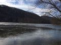
French Broad River
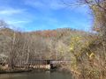
Active Railroad
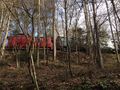
Refurbished RR cars
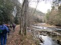
Photo by Gerald


