Laurel Fork Trail: Difference between revisions
m (add map markers back) |
|||
| (30 intermediate revisions by 3 users not shown) | |||
| Line 1: | Line 1: | ||
{{Trail | |||
{{ | |Banner Image=File:DennisCoveFalls.jpg | ||
|City=Hampton | |||
|Land Owner=Cherokee National Forest | |||
|Trail Marking=Blue | |||
|Trail Use=Hiking, Camping, Hunting | |||
|Trail Features=Waterfalls, Mountains | |||
|Difficulty Rating=Hard | |||
|Hike Time=2 hrs | |||
|Trail Distance=7.9 mi | |||
|Round Trip Distance=15.8 mi | |||
|Trail Type=Segment | |||
|High Point=1,607 ft | |||
|Low Point=1,325 ft | |||
|Elevation Gain=338 ft | |||
|Elevation Loss=338 ft | |||
|Elevation Change Direction=West-to-East | |||
|Parking location=36.2567, -82.11139 | |||
|Trailhead location=36.2567, -82.11139 | |||
36. | |||
}} | }} | ||
{{Trail Map}} | |||
__TOC__ | |||
== Trail Overview == | == Trail Overview == | ||
<!-- Enter a overview of the trail. What attracts you to this trail, points of interest, types of flowers, lakes, and peaks that you see along the way. --> | <!-- Enter a overview of the trail. What attracts you to this trail, points of interest, types of flowers, lakes, and peaks that you see along the way. --> | ||
Just a short distance up the road from the Laurel Fork Gorge section of the Appalachian Trail. Marked as '''USFS Trail 39''', this trail provides a remote path along the Laurel Fork backcountry from Dennis Cove Road to Walnut Mountain Road (of the USFS 50 road system). | |||
The trail is blue-blazed with a number of access points using forest roads. There are two (2) popular waterfalls; Dennis Cove Falls and Upper Laurel Falls. Both of which are shortly off-trail; be sure to listen for the falls. A smaller waterfall can be found along Hays Branch on the eastern end of the trail near Walnut Mountain Road. | |||
The trail also has a historical significance as it follows the grade of the old Laurel Fork Railway which was used to transport timber to Hampton (also known as Braemar) to be cut. During the timber cutting, an area of open fields was created known as Frog Level. Today, Frog Level is used for wildlife food plots and limited horseback riding. | |||
== How to get there == | == How to get there == | ||
<!-- Please enter detailed instruction on how to find the trail head. --> | <!-- Please enter detailed instruction on how to find the trail head. --> | ||
The trail has a number of access points. The main and most developed trailhead is on Dennis Cove Road (USFS 50) next to Dennis Cove Recreation Area campground. Continuing to drive on the gravel portion of USFS 50 will lead you to other access points. | |||
'''Kingsport to Dennis Cove Recreation Area:''' | |||
*From Kingsport, travel to Johnston City on I-26. | |||
*Turn onto and follow US 321 to Elizabethton and Hampton. | |||
*Turn into Hampton still following US 321 and turn onto Dennis Cove Road (USFS 50). | |||
*Pass the Appalachian Trail. | |||
*Continue until Dennis Cove Road (USFS 50) crosses the Laurel Fork. A large turnout can be used for parking near the bridge. The road later on turns into Walnut Mountain Road when nearing the community of Buck Mountain. | |||
'''Frog Level:''' | |||
Continue up on the gravel section of USFS 50. Turn down the long and windy USFS 50F which will lead you to a backcountry parking area at Frog Level. USFS 50F maybe unmarked at the turn. It will be approximately 1.8 miles from Dennis Cove Recreation Area, or your first right turn. | |||
'''Bitter End:''' | |||
Access can also be made from USFS 293 from Bitter End area of the Buck Mountain community. About 0.8 miles from the Appalachian Trail. | |||
'''Walnut Mountain Road:''' | |||
The eastern trailhead is located on the gravel section Walnut Mountain Road (USFS 50) is about than 0.1 miles south of primitive White Oak Road. There are no markers or signs for the trailhead; only a faint blue blaze. | |||
Continuing on Walnut Mountain Road (USFS 50), one can turn onto Cherry Flats Road (USFS 50A) as well. The trail crosses and somewhat parallels the road. Continuing down the road, park at the Cherry Flats gates, one can walk down Cherry Flats horse trail (USFS 509A) and pick up the Laurel Fork Trail near the Bitter End access. | |||
== Route Description== | == Route Description== | ||
<!-- Detailed description of the route. Is there any side trails that are worth traveling? --> | <!-- Detailed description of the route. Is there any side trails that are worth traveling? --> | ||
The Laurel Fork Trail travels from Dennis Cove Road (across the small bridge from Dennis Cove Recreation Area/Campground) to Walnut Mountain Road and has a number of access points along the way. The trail mostly follows an old railroad grade. But the mainly obstacle along the trail are a number of water fords and lack of blazing as the trail continues upstream. | The Laurel Fork Trail travels from Dennis Cove Road (across the small bridge from Dennis Cove Recreation Area/Campground) to Walnut Mountain Road and has a number of access points along the way. The trail mostly follows an old railroad grade. But the mainly obstacle along the trail are a number of water fords and lack of blazing and vegetation growth as the trail continues upstream. Be observant to any and all blazing and markers. Follow the waters of the Laurel Fork and stay close to woodline in the open fields. Some of the more obvious trails starting at Bitter End are often spur-trails. | ||
== Typical Conditions == | == Typical Conditions == | ||
<!-- Typical conditions throughout the year of what to expect on the trail. Rocky, muddy, sandy, flowers, lots of downed trees? -->If anything, you will get wet on this trail. The trail conditions are generally good up until after Dennis Cove Falls | <!-- Typical conditions throughout the year of what to expect on the trail. Rocky, muddy, sandy, flowers, lots of downed trees? -->If anything, you will get wet on this trail. Be cautious during periods of high water. This trail has numerous ankle to knee deep fords. With some beaver-dammed areas reaching nearly waist deep. The trail conditions are generally good up until after Dennis Cove Falls. | ||
After Dennis Cove Falls, the trail is less maintained, the creek fords become more difficult, blazing becomes sparse in open- | After Dennis Cove Falls, the trail is less maintained, the creek fords become more difficult, blazing becomes sparse in open-fields around Frog Level, Bitter End, and Walnut Mountain areas, so you will need to be mindful of the route you take. Blowdowns and plant growth become more frequent as the trail continues. | ||
== Fees, Permits, etc. == | == Fees, Permits, etc. == | ||
<!-- Please list any Fees, Permits, Regulations, etc. that may be required on this trail.--> | <!-- Please list any Fees, Permits, Regulations, etc. that may be required on this trail.--> | ||
No fees for day use of the trail. Dennis Cove Recreation Area campground is immediately next to the trail which does carry fees. | |||
== After the Hike == | == After the Hike == | ||
<!-- Other things to check out while you're in the area. Restaurants, attractions, monuments, etc... --> | <!-- Other things to check out while you're in the area. Restaurants, attractions, monuments, etc... --> | ||
== Misc. Information == | == Misc. Information == | ||
<!-- Enter any additional information that doesn't fit an any other fields. Any seasonal features, factoids, etc...? --> | <!-- Enter any additional information that doesn't fit an any other fields. Any seasonal features, factoids, etc...? --> | ||
== Photos == | == Photos == | ||
{{Park trail gallery|Trail={{PAGENAME}}}} | |||
{{Map Marker | |||
|Icon Type=Trail sign | |||
|Marker Title=Laurel Fork Trail-Dennis Cove Road trailhead | |||
|Marker Location=36.2566977,-82.111387 | |||
}} | |||
{{Map Marker | |||
|Icon Type=Trail sign | |||
|Marker Title=Laurel Fork Trail-Frog Level trailhead | |||
|Marker Location=36.2449308,-82.087870 | |||
}} | |||
{{Map Marker | |||
|Icon Type=Trail sign | |||
|Marker Title=Laurel Fork Trail-Bitter End trailhead | |||
|Marker Location=36.222283,-82.037637 | |||
}} | |||
{{Map Marker | |||
|Icon Type=Trail sign | |||
|Marker Title=Laurel Fork Trail-Forest Road trailhead | |||
|Marker Location=36.230246,-82.036242 | |||
}} | |||
{{Map Marker | |||
|Icon Type=Trail sign | |||
|Marker Title=Laurel Fork Trail-Walnut Mtn Road trailhead | |||
|Marker Location=36.239081,-82.028346 | |||
}} | |||
Latest revision as of 16:33, 19 September 2021
| Laurel Fork Trail (log in to submit report) | |
|---|---|

| |
| Land Owner | Cherokee National Forest |
| Located | Hampton, Tennessee |
| Trail Marking | Blue |
| Trail UseThings allowed to do on or near the trail |
|
| FeaturesThings to see on or near the trail |
|
| Difficulty Rating | Hard |
| Hiking TimeTime from car and back. Includes any time hiking to access this trail. | 2 hrs0.125 Days <br />120 Min <br /> round trip |
| Distance: | 7.9 mi12.714 km <br /> trailStrict non-repeating trail length / 15.8 mi25.428 km <br /> round tripTypical or shortest length from the car, hike the trail, and return to car |
| Trail Type | Segment |
| Low / High Point | 1,325 ft441.667 Yards <br />403.86 Meters <br /> / 1,607 ft535.667 Yards <br />489.814 Meters <br /> |
| Elev. Gain/LossSee link for details of calculation. Gain/Loss is direction dependent. | 338 ft103.022 Meters <br /> / (338 ft103.022 Meters <br />) – West-to-East |
| Trip ReportsFrom user "hiked it" submissions<br />Recent is within last 90 days | No hikes logged yet |
| NearbyWithin 5 mi<br />Click link to view list | 4 trails / 32.7 mi of trail |
| Parking | 36° 15' 24.12" N, 82° 6' 41.00" W Map |
| Trailhead | 36° 15' 24.12" N, 82° 6' 41.00" W Map |
|
| |
| Show In Google Maps | |
Trail Overview[edit]
Just a short distance up the road from the Laurel Fork Gorge section of the Appalachian Trail. Marked as USFS Trail 39, this trail provides a remote path along the Laurel Fork backcountry from Dennis Cove Road to Walnut Mountain Road (of the USFS 50 road system).
The trail is blue-blazed with a number of access points using forest roads. There are two (2) popular waterfalls; Dennis Cove Falls and Upper Laurel Falls. Both of which are shortly off-trail; be sure to listen for the falls. A smaller waterfall can be found along Hays Branch on the eastern end of the trail near Walnut Mountain Road.
The trail also has a historical significance as it follows the grade of the old Laurel Fork Railway which was used to transport timber to Hampton (also known as Braemar) to be cut. During the timber cutting, an area of open fields was created known as Frog Level. Today, Frog Level is used for wildlife food plots and limited horseback riding.
How to get there[edit]
The trail has a number of access points. The main and most developed trailhead is on Dennis Cove Road (USFS 50) next to Dennis Cove Recreation Area campground. Continuing to drive on the gravel portion of USFS 50 will lead you to other access points.
Kingsport to Dennis Cove Recreation Area:
- From Kingsport, travel to Johnston City on I-26.
- Turn onto and follow US 321 to Elizabethton and Hampton.
- Turn into Hampton still following US 321 and turn onto Dennis Cove Road (USFS 50).
- Pass the Appalachian Trail.
- Continue until Dennis Cove Road (USFS 50) crosses the Laurel Fork. A large turnout can be used for parking near the bridge. The road later on turns into Walnut Mountain Road when nearing the community of Buck Mountain.
Frog Level: Continue up on the gravel section of USFS 50. Turn down the long and windy USFS 50F which will lead you to a backcountry parking area at Frog Level. USFS 50F maybe unmarked at the turn. It will be approximately 1.8 miles from Dennis Cove Recreation Area, or your first right turn.
Bitter End: Access can also be made from USFS 293 from Bitter End area of the Buck Mountain community. About 0.8 miles from the Appalachian Trail.
Walnut Mountain Road: The eastern trailhead is located on the gravel section Walnut Mountain Road (USFS 50) is about than 0.1 miles south of primitive White Oak Road. There are no markers or signs for the trailhead; only a faint blue blaze.
Continuing on Walnut Mountain Road (USFS 50), one can turn onto Cherry Flats Road (USFS 50A) as well. The trail crosses and somewhat parallels the road. Continuing down the road, park at the Cherry Flats gates, one can walk down Cherry Flats horse trail (USFS 509A) and pick up the Laurel Fork Trail near the Bitter End access.
Route Description[edit]
The Laurel Fork Trail travels from Dennis Cove Road (across the small bridge from Dennis Cove Recreation Area/Campground) to Walnut Mountain Road and has a number of access points along the way. The trail mostly follows an old railroad grade. But the mainly obstacle along the trail are a number of water fords and lack of blazing and vegetation growth as the trail continues upstream. Be observant to any and all blazing and markers. Follow the waters of the Laurel Fork and stay close to woodline in the open fields. Some of the more obvious trails starting at Bitter End are often spur-trails.
Typical Conditions[edit]
If anything, you will get wet on this trail. Be cautious during periods of high water. This trail has numerous ankle to knee deep fords. With some beaver-dammed areas reaching nearly waist deep. The trail conditions are generally good up until after Dennis Cove Falls.
After Dennis Cove Falls, the trail is less maintained, the creek fords become more difficult, blazing becomes sparse in open-fields around Frog Level, Bitter End, and Walnut Mountain areas, so you will need to be mindful of the route you take. Blowdowns and plant growth become more frequent as the trail continues.
Fees, Permits, etc.[edit]
No fees for day use of the trail. Dennis Cove Recreation Area campground is immediately next to the trail which does carry fees.
After the Hike[edit]
Misc. Information[edit]
Photos[edit]
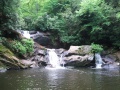
Dennis Cove Falls along the Laurel Fork Trail
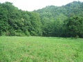
Frog Level (no clue about the genesis of that name!)
