Laurel Fork Gorge: Difference between revisions
(→Maps) |
(→Photos) |
||
| Line 107: | Line 107: | ||
Image:PotatoTop.jpg|View of Laurel Fork Gorge from Potato Top | Image:PotatoTop.jpg|View of Laurel Fork Gorge from Potato Top | ||
Image:White_Rhododendron_Bloom.JPG|White Rhododendron bloom | Image:White_Rhododendron_Bloom.JPG|White Rhododendron bloom | ||
Image:Laurelforkfalls2.jpg | Image:Laurelforkfalls2.jpg|Laurel Fork Falls | ||
Image:Laurel Fork Gorge steps.JPG|Steps heading up! | Image:Laurel Fork Gorge steps.JPG|Steps heading up! | ||
<!-- Do not remove the end gallery code.--> | <!-- Do not remove the end gallery code.--> | ||
Revision as of 15:29, 4 July 2012
| |||||||||||||||||||||||||||||||||||||
Trail Overview
The Appalachian Trail travels through Laurel Fork Gorge, rarely straying far from the creek. Probably the most popular hiking destination for TEHCC is Laurel Fork Falls, a 50' cascading waterfall. There are AT access points at both the NW end of the gorge (Hampton) and SE (Dennis Cove).
Swimming is not allowed at the falls because of dangerous undertow in the pool. Wading downstream of the falls is suggested for enjoyment.
How to get there
Hampton
- From Elizabethton, go southeast on US 321 through Hampton for 1.3 miles.
- Look for parking area on the right.
Follow blue blazed trail to AT.
Dennis Cove
- From Elizabethton, go southeast on US 321 through Hampton for 0.8 miles.
- Turn right (south) on FR 50 (Dennis Cove Road) and travel 3.9 curvy miles.
- Look for AT access parking area on your left.
Route Description
The listed mileage and elevation change are for complete end-to-end and return hike. More typically the day hikes are an out-and-back from either access point. From Hampton, it's a 5.5 mile round trip. From Dennis Cover, it's about 2.6 miles round trip.
Typical Conditions
Well maintained Appalachian Trail, including blue blazed side trail from Hampton. Sometimes during spring, the upper trail may be required due to flooding.
Fees, Permits, etc.
Group size is limited to 10 people in the Pond Mountain Wilderness Area. Also dogs must be on leashes.
After the Hike
Misc. Information
A bit of history...
The Koonford Bridge was destroyed by flooding in 1998. Its center span was replaced few weeks later in one day by many volunteers. story link Two further wilderness trail bridges destroyed in the same flood were replaced before the thru-hikers arrived that year. And the rock steps by the falls were also created in 1998 through concerted effort. story link2
Forest Service website information.
Maps
<googlemap version="0.9" lat="36.275" lon="-82.148" type="terrain" zoom="14" width="725" scale="yes" icons="http://tehcc.org/clubwiki/kml/marker{label}.png"> http://tehcc.org/clubwiki/kml/Hampton_Blueline_Trail_501.kml http://tehcc.org/clubwiki/kml/High_Water_Trail.kml
(C) 36.27277,-82.135
Laurel Fork Falls
 (A) 36.264067, -82.1231
Trailhead - Dennis Cove
(A) 36.264067, -82.1231
Trailhead - Dennis Cove
(A) 36.28532,-82.15212
Trailhead - Hampton
 (G) 36.28211,-82.14852
Entering Pond Mtn Wilderness
(G) 36.28211,-82.14852
Entering Pond Mtn Wilderness
 (G) 36.28151,-82.14323
Intersection with AT
(G) 36.28151,-82.14323
Intersection with AT
 (L) 36.28298,-82.14083
Trail Bridge #1
(L) 36.28298,-82.14083
Trail Bridge #1
 (L) 36.281083,-82.137539
Trail Bridge #2
(L) 36.281083,-82.137539
Trail Bridge #2

(F) 36.278642,-82.136229
Laurel Fork Shelter

(G) 36.273014,-82.132099
Intersection AT/High Water Trail
 (O) 36.279362,-82.135381
</googlemap>
Photos
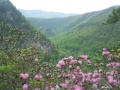
View of Laurel Fork Gorge from Potato Top
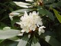
White Rhododendron bloom
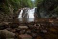
Laurel Fork Falls
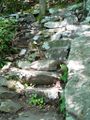
Steps heading up!


