Laurel Fork Gorge: Difference between revisions
(→Maps: Added pin for AT/High Water trail - north end) |
|||
| (17 intermediate revisions by 3 users not shown) | |||
| Line 1: | Line 1: | ||
{{Trail | |||
{{ | |Banner Image=File:Laurel Fork Gorge Falls.JPG | ||
|Trail Number=501 | |||
|City=Hampton | |||
|Land Owner=Cherokee National Forest | |||
|Wilderness Area=Pond Mountain Wilderness Area | |||
|Trail Marking=Blue/AT White | |||
|Trail Use=Hiking, Camping, Hunting | |||
|Trail Features=Waterfalls, Vistas, Rivers | |||
|Difficulty Rating=Medium | |||
|Hike Time=4 Hours | |||
|Trail Distance=2.57 mi | |||
|Round Trip Distance=5.5 mi | |||
|Trail Type=In-and-Out | |||
|High Point=2,315 Ft | |||
|Low Point=1,853 ft | |||
|Elevation Gain=624 Ft | |||
|Elevation Loss=164 Ft | |||
|Elevation Change Direction=North-to-South | |||
|Parking location=36.28556, -82.15213 | |||
|Trailhead location=36.28556, -82.15213 | |||
}} | }} | ||
{{Trail Map}} | |||
__TOC__ | |||
== Trail Overview == | == Trail Overview == | ||
<!-- Enter a overview of the trail. What attracts you to this trail, points of interest, types of flowers, lakes, and peaks that you see along the way. --> | <!-- Enter a overview of the trail. What attracts you to this trail, points of interest, types of flowers, lakes, and peaks that you see along the way. --> | ||
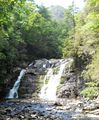
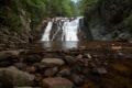
The [[Dennis Cove Rd to Wilbur Dam Rd|Appalachian Trail]] travels through Laurel Fork Gorge, rarely straying far from the creek. Probably the most popular hiking destination for TEHCC is Laurel Fork Falls, a 50' cascading waterfall. There are AT access points at both the NW end of the gorge (Hampton) and SE (Dennis Cove). | The [[Dennis Cove Rd to Wilbur Dam Rd|Appalachian Trail]] travels through Laurel Fork Gorge, rarely straying far from the creek. Probably the most popular hiking destination for TEHCC is Laurel Fork Falls, a 50' cascading waterfall. There are AT access points at both the NW end of the gorge (Hampton) and SE (Dennis Cove). | ||
Swimming is not allowed at the falls because of dangerous undertow in the pool. SEVERAL PEOPLE HAVE DIED HERE INCLUDING THOSE COMING TO HELP. They were not being seemingly careless, not drinking, not jumping from the top, simply swimming near the falls. There is an underwater rock shelf in the deep pool below the falls. The strong current will take swimmers underwater and keep them trapped below the shelf. Therefore, wading downstream of the falls is suggested for enjoyment. | |||
Swimming is not allowed at the falls because of dangerous undertow in the pool. | |||
== How to get there == | == How to get there == | ||
| Line 40: | Line 44: | ||
== Route Description== | == Route Description== | ||
<!-- Detailed description of the route. Is there any side trails that are worth traveling? --> | <!-- Detailed description of the route. Is there any side trails that are worth traveling? --> | ||
The listed mileage and elevation change are for complete end-to-end and return hike. More typically the day hikes are an out-and-back from either access point. From Hampton, it's a 5.5 mile round trip. From Dennis | The listed mileage and elevation change are for complete end-to-end and return hike. More typically the day hikes are an out-and-back from either access point. From Hampton, it's a 5.5 mile round trip. From Dennis Cove, it's about 2.6 miles round trip. | ||
== Typical Conditions == | == Typical Conditions == | ||
| Line 48: | Line 52: | ||
== Fees, Permits, etc. == | == Fees, Permits, etc. == | ||
<!-- Please list any Fees, Permits, Regulations, etc. that may be required on this trail.--> | <!-- Please list any Fees, Permits, Regulations, etc. that may be required on this trail.--> | ||
Group size is limited to 10 people in the Pond Mountain Wilderness Area. Also dogs must be on leashes. | '''Group size is limited to 10 people in the Pond Mountain Wilderness Area.''' Also dogs must be on leashes. | ||
Overnight parking is not recommended at Hampton trailhead due to occasional vandalism to break into vehicles to steal items. | |||
== After the Hike == | == After the Hike == | ||
| Line 57: | Line 63: | ||
<!-- Enter any additional information that doesn't fit an any other fields. Any seasonal features, factoids, etc...? --> | <!-- Enter any additional information that doesn't fit an any other fields. Any seasonal features, factoids, etc...? --> | ||
A bit of history...<br> | A bit of history...<br> | ||
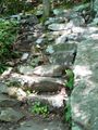
The Koonford Bridge was destroyed by flooding in 1998. Its center span was replaced few weeks later in one day by many volunteers. [http://tehcc.org/1999/01/koonford-bridge-in-laurel-fork-gorge-1998/ story link] Two further wilderness trail bridges destroyed in the same flood were replaced before the thru-hikers arrived that year. And the rock steps by the falls were also created in 1998 through concerted effort. [http://tehcc.org/1998/09/laurel-fork-gorge-rock-steps-1998/ story link2] | The Koonford Bridge was destroyed by flooding in 1998. Its center span was replaced few weeks later in one day by many volunteers. [http://tehcc.org/1999/01/koonford-bridge-in-laurel-fork-gorge-1998/ story link] Two further wilderness trail bridges destroyed in the same flood were replaced before the thru-hikers arrived that year. And the rock steps by the falls were also created in 1998 through concerted effort. [http://tehcc.org/1998/09/laurel-fork-gorge-rock-steps-1998/ story link2] The entire Koonford Bridge was replaced in 2014. | ||
Forest Service [ | Forest Service [https://www.fs.usda.gov/recarea/cherokee/recarea/?recid=35016 website] information. | ||
== Photos == | == Photos == | ||
{{Park trail gallery|Trail={{PAGENAME}}}} | |||
Latest revision as of 14:05, 17 July 2023
| Laurel Fork Gorge (log in to submit report) | |
|---|---|

| |
| Trail Number | 501 |
| Land Owner | Cherokee National Forest |
| Wilderness Area | Pond Mountain Wilderness Area |
| Located | Hampton, Tennessee |
| Trail Marking | Blue/AT White |
| Trail UseThings allowed to do on or near the trail |
|
| FeaturesThings to see on or near the trail |
|
| Difficulty Rating | Medium |
| Hiking TimeTime from car and back. Includes any time hiking to access this trail. | 4 Hours0.25 Days <br />240 Min <br /> round trip |
| Distance: | 2.57 mi4.136 km <br /> trailStrict non-repeating trail length / 5.5 mi8.851 km <br /> round tripTypical or shortest length from the car, hike the trail, and return to car |
| Trail Type | In-and-Out |
| Low / High Point | 1,853 ft617.667 Yards <br />564.794 Meters <br /> / 2,315 Ft771.667 Yards <br />705.612 Meters <br /> |
| Elev. Gain/LossSee link for details of calculation. Gain/Loss is direction dependent. | 624 Ft190.195 Meters <br /> / (164 Ft49.987 Meters <br />) – North-to-South |
| Trip ReportsFrom user "hiked it" submissions<br />Recent is within last 90 days | 4 logged hikes (0 recent) |
| NearbyWithin 5 mi<br />Click link to view list | 4 trails / 38.0 mi of trail |
| Parking | 36° 17' 8.02" N, 82° 9' 7.67" W Map |
| Trailhead | 36° 17' 8.02" N, 82° 9' 7.67" W Map |
|
| |
| Show In Google Maps | |
Download KML / Upload new version / KML File Page / Create Profile Chart / gpsvisualizer Map
Trail Overview[edit]
The Appalachian Trail travels through Laurel Fork Gorge, rarely straying far from the creek. Probably the most popular hiking destination for TEHCC is Laurel Fork Falls, a 50' cascading waterfall. There are AT access points at both the NW end of the gorge (Hampton) and SE (Dennis Cove).
Swimming is not allowed at the falls because of dangerous undertow in the pool. SEVERAL PEOPLE HAVE DIED HERE INCLUDING THOSE COMING TO HELP. They were not being seemingly careless, not drinking, not jumping from the top, simply swimming near the falls. There is an underwater rock shelf in the deep pool below the falls. The strong current will take swimmers underwater and keep them trapped below the shelf. Therefore, wading downstream of the falls is suggested for enjoyment.
How to get there[edit]
Hampton
- From Elizabethton, go southeast on US 321 through Hampton for 1.3 miles.
- Look for parking area on the right.
Follow blue blazed trail to AT.
Dennis Cove
- From Elizabethton, go southeast on US 321 through Hampton for 0.8 miles.
- Turn right (south) on FR 50 (Dennis Cove Road) and travel 3.9 curvy miles.
- Look for AT access parking area on your left.
Route Description[edit]
The listed mileage and elevation change are for complete end-to-end and return hike. More typically the day hikes are an out-and-back from either access point. From Hampton, it's a 5.5 mile round trip. From Dennis Cove, it's about 2.6 miles round trip.
Typical Conditions[edit]
Well maintained Appalachian Trail, including blue blazed side trail from Hampton. Sometimes during spring, the upper trail may be required due to flooding.
Fees, Permits, etc.[edit]
Group size is limited to 10 people in the Pond Mountain Wilderness Area. Also dogs must be on leashes.
Overnight parking is not recommended at Hampton trailhead due to occasional vandalism to break into vehicles to steal items.
After the Hike[edit]
Misc. Information[edit]
A bit of history...
The Koonford Bridge was destroyed by flooding in 1998. Its center span was replaced few weeks later in one day by many volunteers. story link Two further wilderness trail bridges destroyed in the same flood were replaced before the thru-hikers arrived that year. And the rock steps by the falls were also created in 1998 through concerted effort. story link2 The entire Koonford Bridge was replaced in 2014.
Forest Service website information.
Photos[edit]
Laurel Fork Falls
Steps heading up!
Laurel Fork Falls
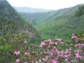
View of Laurel Fork Gorge from Potato Top
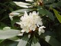
White Rhododendron bloom


