Lakeside Trail: Difference between revisions
(Added googlemap) |
m (→Trail Overview: typo fix) |
||
| (38 intermediate revisions by 4 users not shown) | |||
| Line 1: | Line 1: | ||
== Trail | {{Trail | ||
Very popular hiking loop trail around the | |Banner Image=File:Lakeside Trail - Bays Mountain Dam.jpg | ||
|Park=Bays Mountain Park | |||
|City=Kingsport | |||
|Land Owner=City of Kingsport | |||
|Trail Marking=Signs | |||
|Trail Use=Hiking, Geocaching | |||
|Trail Features=Lakes, Mountains | |||
|Difficulty Rating=Medium | |||
|Hike Time=1.5 hr | |||
|Trail Distance=2.316 mi | |||
|Round Trip Distance=2.316 mi | |||
|Trail Type=Loop | |||
|High Point=1,922 ft | |||
|Low Point=1,826 ft | |||
|Elevation Gain=143 ft | |||
|Elevation Loss=145 ft | |||
|Elevation Change Direction=Counter Clockwise | |||
|Parking location=36.50882, -82.60955 | |||
|Trailhead location=36.50889, -82.6114 | |||
}} | |||
{{Trail Map|Other Trails=Fire Tower Trail}} | |||
__TOC__ | |||
== Trail Overview == | |||
<!-- Enter a overview of the trail. What attracts you to this trail, points of interest, types of flowers, lakes, and peaks that you see along the way. --> | |||
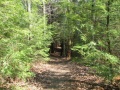
Located at [[Bays Mountain Park]]. Very popular hiking loop trail around the reservoir. It connects with many other park trails, thus a common starting point. Officially takes 90 minutes on maintained path with moderate climbs and drops. A few benches are scattered along the trail. Points of interest include floating bridge, beaver activity (dams, lodges, and down/gnawed trees), lilypad pond, and the wolves and other animal habitats. Note red dirt from maroon shale in places. | |||
== How to get there == | |||
<!-- Please enter detailed instruction on how to find the trail head. --> | |||
From parking lot, either cross the dam to hike in a clockwise direction or start at back of animal habitat by the aviary area. | |||
== Route Description== | |||
<!-- Detailed description of the route. Is there any side trails that are worth traveling? --> | |||
This trail has connections to [[Trail connects to::Bays Ridge Road]], [[Trail connects to::Lake Road (Bays Mountain Park)|Lake Road]], [[Trail connects to::Cherry Knobs]], [[Trail connects to::Sweet Gum Trail]], [[Trail connects to::Food Plot Road]], [[Trail connects to::Hemlock Trail]], [[Trail connects to::Holly Trail]], [[Trail connects to::Towhee Trail]], [[Trail connects to::Fern Trail]], and [[Trail connects to::Dolan Branch Trail]]. | |||
{| class="wikitable" border="1" | {| class="wikitable" border="1" | ||
| Line 25: | Line 58: | ||
|- | |- | ||
|0.5 | |0.5 | ||
|Cherry Knobs | |Cherry Knobs junction | ||
|1.9 | |1.9 | ||
|- | |- | ||
| Line 33: | Line 66: | ||
|- | |- | ||
|1.6 | |1.6 | ||
|Hemlock Tr./ ( | |Hemlock Tr./ (Fire Tower Trail) junction | ||
|0.8 | |0.8 | ||
|- | |- | ||
| Line 57: | Line 90: | ||
|} | |} | ||
== | == Typical Conditions == | ||
<!-- | <!-- Typical conditions throughout the year of what to expect on the trail. Rocky, muddy, sandy, flowers, lots of downed trees? --> | ||
The park does an excellent job keeping this most popular trail open. The path is heavily used, but sometime covered with mulch. | |||
== Regulations == | |||
< | NO BIKES! | ||
<br>Dogs are not allowed around the animal habitats, thus may have to skirt using Lake Road. | |||
== After the Hike == | |||
<!-- Other things to check out while you're in the area. Restaurants, attractions, monuments, etc... --> | |||
The animal habitats are a hit with kids of all ages. | |||
== | == Misc. Information == | ||
<!-- Enter any additional information that doesn't fit an any other fields. Does this trail require any permits for overnight? parking? --> | |||
<!-- | |||
To get to the park a $5 gate fee is required. Yearly memberships can also be purchased. | |||
[[ | == Photos == | ||
{{Park trail gallery|Trail={{PAGENAME}}}} | |||
{{Map Marker | |||
|Icon Type=Point of interest | |||
|Marker Title=Beginning of dam bridge | |||
|Marker Location=36.508894,-82.611436 | |||
}} | |||
{{Map Marker | |||
|Icon Type=Trail bridge | |||
|Marker Title=Floating bridge | |||
|Marker Description=[[Image:BMP Lakeside Trail floating bridge.JPG|150px]] | |||
|Marker Location=36.50508,-82.61732 | |||
}} | |||
{{Map Marker | |||
|Icon Type=Trail sign | |||
|Marker Title=Junction with [[Cherry Knobs|Cherry Knobs]] | |||
|Marker Location=36.50578,-82.61832 | |||
}} | |||
{{Map Marker | |||
|Icon Type=Trail bridge | |||
|Marker Title=Fixed bridge | |||
|Marker Location=36.50596,-82.62100 | |||
}} | |||
{{Map Marker | |||
|Icon Type=Trail bridge | |||
|Marker Title=Fixed bridge | |||
|Marker Location=36.50874,-82.62153 | |||
}} | |||
{{Map Marker | |||
|Icon Type=Trail bridge | |||
|Marker Title=Fixed bridge | |||
|Marker Location=36.51039,-82.61639 | |||
}} | |||
{{Map Marker | |||
|Icon Type=Trail bridge | |||
|Marker Title=Fixed bridge | |||
|Marker Location=36.51131,-82.61443 | |||
}} | |||
{{Map Marker | |||
|Icon Type=Water crossing | |||
|Marker Title=No bridge at spring - pass around on uphill side | |||
|Marker Location=36.51267,-82.60963 | |||
}} | |||
{{Map Marker | |||
|Icon Type=Trail bridge | |||
|Marker Title=New trail bridge | |||
|Marker Location=36.51215,-82.60779 | |||
}} | |||
Latest revision as of 17:12, 19 March 2023
| Lakeside Trail (log in to submit report) | |
|---|---|

| |
| Park | Bays Mountain Park |
| Land Owner | City of Kingsport |
| Located | Kingsport, Tennessee |
| Trail Marking | Signs |
| Trail UseThings allowed to do on or near the trail |
|
| FeaturesThings to see on or near the trail |
|
| Difficulty Rating | Medium |
| Hiking TimeTime from car and back. Includes any time hiking to access this trail. | 1.5 hr0.0938 Days <br />90 Min <br /> round trip |
| Distance: | 2.316 mi3.727 km <br /> trailStrict non-repeating trail length / 2.316 mi3.727 km <br /> round tripTypical or shortest length from the car, hike the trail, and return to car |
| Trail Type | Loop |
| Low / High Point | 1,826 ft608.667 Yards <br />556.565 Meters <br /> / 1,922 ft640.667 Yards <br />585.826 Meters <br /> |
| Elev. Gain/LossSee link for details of calculation. Gain/Loss is direction dependent. | 143 ft43.586 Meters <br /> / (145 ft44.196 Meters <br />) – Counter Clockwise |
| Trip ReportsFrom user "hiked it" submissions<br />Recent is within last 90 days | 3 logged hikes (0 recent) |
| NearbyWithin 5 mi<br />Click link to view list | 32 trails / 36.2 mi of trail |
| Parking | 36° 30' 31.75" N, 82° 36' 34.38" W Map |
| Trailhead | 36° 30' 32.00" N, 82° 36' 41.04" W Map |
|
| |
| Show In Google Maps | |
Download KML / Upload new version / KML File Page / Create Profile Chart / gpsvisualizer Map
Trail Overview[edit]
Located at Bays Mountain Park. Very popular hiking loop trail around the reservoir. It connects with many other park trails, thus a common starting point. Officially takes 90 minutes on maintained path with moderate climbs and drops. A few benches are scattered along the trail. Points of interest include floating bridge, beaver activity (dams, lodges, and down/gnawed trees), lilypad pond, and the wolves and other animal habitats. Note red dirt from maroon shale in places.
How to get there[edit]
From parking lot, either cross the dam to hike in a clockwise direction or start at back of animal habitat by the aviary area.
Route Description[edit]
This trail has connections to Bays Ridge Road, Lake Road, Cherry Knobs, Sweet Gum Trail, Food Plot Road, Hemlock Trail, Holly Trail, Towhee Trail, Fern Trail, and Dolan Branch Trail.
| Miles | Lakeside Trail | Miles |
|---|---|---|
| 0.0 | Dam, end nearest Nature Center | 2.4 |
| 0.1 | Dam, far end | 2.3 |
| 0.2 | Pine Trail junction | 2.2 |
| 0.4 | Floating Bridge | 2.0 |
| 0.5 | Cherry Knobs junction | 1.9 |
| 1.1 | Beaver Pond Bridge/ Sweet Gum Trail junction | 1.3 |
| 1.6 | Hemlock Tr./ (Fire Tower Trail) junction | 0.8 |
| 1.7 | Holly Trail/ Towhee Trail junction | 0.7 |
| 1.8 | Holly Trail junction | 0.6 |
| 2.1 | Fern Trail junction | 0.3 |
| 2.3 | Water Fowl Aviary/ Laurel Trail junction | 0.1 |
| 2.4 | Nature Center | 0.0 |
Typical Conditions[edit]
The park does an excellent job keeping this most popular trail open. The path is heavily used, but sometime covered with mulch.
Regulations[edit]
NO BIKES!
Dogs are not allowed around the animal habitats, thus may have to skirt using Lake Road.
After the Hike[edit]
The animal habitats are a hit with kids of all ages.
Misc. Information[edit]
To get to the park a $5 gate fee is required. Yearly memberships can also be purchased.
Photos[edit]
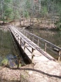
Floating bridge to cross lake on west end of loop
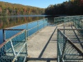
Dam crossing at Bays Mountain Park - Photo by Vic Hasler
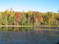
Look at reservoir from former avery area along Lakeside Trail - photo by Vic Hasler
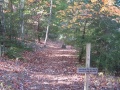
Lakeside trailhead from dam - Photo by Vic Hasler
Walking through evergreen grove on Lakeside Trail - photo by Vic Hasler


