Lake Keokee Loop Trail: Difference between revisions
(→Photos: Added first pix) |
(→Photos) |
||
| Line 72: | Line 72: | ||
<!-- Place any pictures from this trail below. Add a picture by typing Image:imagename.extension --> | <!-- Place any pictures from this trail below. Add a picture by typing Image:imagename.extension --> | ||
Image:Lake Keokee from dam.JPG|View of Lake Keokee from dam | Image:Lake Keokee from dam.JPG|View of Lake Keokee from dam | ||
Image:Double yellow blaze.JPG|Watch carefully for this sharp turn | |||
<!-- Do not remove the end gallery code.--> | <!-- Do not remove the end gallery code.--> | ||
</gallery> | </gallery> | ||
Revision as of 19:35, 1 December 2012
| |||||||||||||||||||||||||||||||||||||

Trail Overview
Easy hike through woodlands around the manmade lake. Good for bird watching or wildflowers in season.
How to get there
From Kingsport, TN
- North on US-23 to Big Stone Gap.
- Wander thru town on US-23 and continue to Appalachia.
- Left/north onto VA-68 (Inman Street) for six miles.
- Continue straight onto SR-606 a couple of miles.
- Turn left/east onto SR-623 for half mile.
- Turn left/east onto SR-876 and proceed one mile to Lake Keokee Recreation Area.
Trailheads at parking lot are NOT marked. Heading west immediately crosses a bridge, while the east side loop begin with the walkway to the observation pier.
Route Description
Lightly used, hardpacked trail winding around the lake – crossing the dam. In June, flame azaleas can be seen in bloom.
Olinger Gap Trail (1 mile) connects the Keokee Lake Loop Trail to the Stone Mountain Trail.
Typical Conditions
The district has cleared the trail from severe damaged caused by a December 2009 ice storm. The trail sometimes follows old fire roads or wanders just above the lake. There are some dense rhododendron growths.
Fees, Permits, etc.
Open year-round. No fees or permits are required for day hiking. Managed by the Clinch Ranger District (Wise, VA) Tel: 276-328-2931 (M-F 8AM-4:30PM)
After the Hike
Misc. Information
Forest Service usda.gov trail page and fed.us trail webpage
Lake Keokee was created by damming the Powell River in 1975 to provide recreation opportunities. No gasoline motors are allowed on the lake, so it is quiet as fishing is done from canoes or flatboats.
Maps
<googlemap version="0.9" lat="36.849957" lon="-82.861717" type="terrain" zoom="15" scale="yes" icons="http://tehcc.org/clubwiki/kml/marker{label}.png">
http://tehcc.org/clubwiki/kml/Lake Keokee Trail.kml http://tehcc.org/clubwiki/kml/Olinger_Gap_Trail_partial.kml
(A) 36.85485,-82.86265 Parking at recreation area </googlemap>
Photos
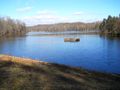
View of Lake Keokee from dam
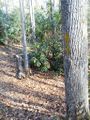
Watch carefully for this sharp turn

